
The Moulin de Bougès
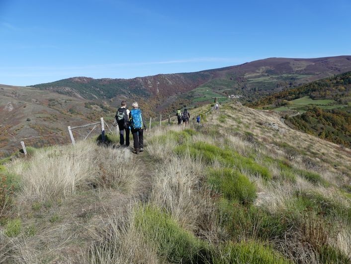
After a beautiful climb onto the ridges of the Serre de Rébiouse, hikers are rewarded with a superb view onto the heather slopes of the Bougès massif. Then the path zigzags back downhill into the chestnut grove with its many clèdes (buildings for drying chestnuts) and terraced cropland.
7 points of interest
Château de Saint-Julien-d'Arpaon - nathalie.thomas  History
St-Julien-d'Arpaon
During the night of Saturday 22 to Sunday 23 July 1702, after Magdalene Fair, a gathering was held in a wood “near Saint-Julien”. The future leaders of the first Camisards(Protestants rebelling against Catholic rule) began recruiting volunteers to free prisoners. On 18 October 1702, after killing Salomon Gardès, secretary to Abbot du Chaila, the Camisard troops led by Gédéon Laporte burnt down the Catholic church, vicarage and house of the notary Delapierre, The temple (Protestant church) was built in 1840.
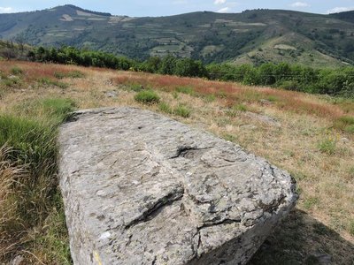
La pierre de baptême près du hameau de Bougès - OT Gorges du Tarn Causses & Cévennes NC HistoryThe baptismal stone
In the Cévennes, during the troubled times of the 17th and 18th centuries – from the Revocation of the Edict of Nantes to the Camisard War – the Protestant population distrusted priests.
At the Col de l’Agulharou pass is a large sculpted schist slab, into which is carved a hole “as large as a soup tureen: this is the baptismal stone. Those who didn’t want to go and find the parish priest had their children baptised there with the water falling from the sky.” This large stone has three basins (cupulae) carved into it: one is about 15 cm wide; the other two are smaller and were made in prehistoric times.
(Excerpt from La Revue des Cévennes: Désert et pays camisard)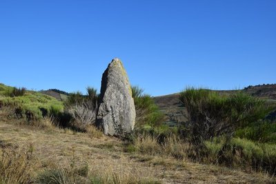
Menhirs - © com com Florac Sud Lozère  Archaeology
The menhirs on the ground
"Two menhirs are lying on the ground just before the Col de l'Agulharon. One has three cup marks (circular hollows), one of which is the size of a bowl. Many schist slabs with cup marks have been identified in the Cévennes. These carvings, whose meaning escapes us, have been attributed to the Neolithic, as have the menhirs. The stone with cup marks is known as “the baptism stone”. When the Edict of Nantes was revoked in 1685, making it illegal to practice Protestantism in France, many Protestants refused to convert. They waited for a pastor to visit to receive the sacraments. This stone was allegedly used to baptise children.” (P. Grime)
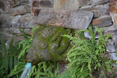
Fontaine à tête de mouton - © com com Florac Sud Lozère HistoryBougès
The hamlet of Bougès currently has two year-round homes. In the summer, there are 80 to 90 inhabitants descended from families that were originally from here. In 1970, only one couple of retired farmers remained. Then another farming couple settled here: “there was broom right to the doors of the houses”. They restored the terraced meadows and fields that go up in steps behind the hamlet. Today, a farming couple produces Pélardon goats' cheese, and you may well meet their goats grazing calmly under the chestnut trees.
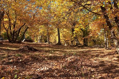
Châtaigneraie en Cévennes - © Guy Grégoire HistoryHistory of the path
Not so long ago, the inhabitants of Bougès still gathered chestnuts here. “We gathered them in the 60s, those were the last years. I saw my parents gathering them, they carried everything on their backs. It was one hell of a job carrying them back up that path.”
More recently, the path was still in use. “That path was the postman's path. He came from Saint-Julien by Mijavols, and then he left this way, jumped across the footbridge and went up the other slope. In the old days, the postman walked 40 kilometres a day, it wasn't a restful job.”
The path was used for taking grains from Bougès down to the mill near the railway track. That made it necessary to carry out major improvements, which you can still see today. A supporting wall keeps the path's foundations in place while shaped rock or a hand-built wall protects it from rock slides. Creating many hairpin bends made it possible to reduce the slope's gradient.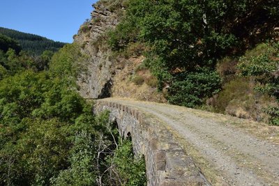
Pont sur le CéFéDé - © com com Florac Sud Lozère HistoryThe CFD (mountain-bike route)
Users and employees still talk of the former railway (CFD) with regret and emotion:
“To go to Montpellier on Mondays, I could leave at 6 in the morning, and arrive in Montpellier at 10, and you could get back here in the evening. The train arrived at 10 o'clock in the evening. Now (with the coach), you can go down, but you have to wait for the next day to come back up. It was very useful. Nowadays, if you don't have a car, what do you do? You hitch-hike, you walk!” (P. Grime)
“Two years after the train was shut down, we had the idea of putting it back on the track and turning it into a tourist train. We managed to get a railcar to start... We hadn't told anyone: apparently we didn't have the right to do it, we even risked getting a correctional sentence. Nothing happened... Except that at St-Julien-des-Points we gave a blast of this kind of horn that we had, and M., from the restaurant, came up with a litre of pastis, and two or three farmers from the area arrived too. We all cried like babies. We had the impression that the heart of the area was beating again.” (Revue Cévennes, issue 15)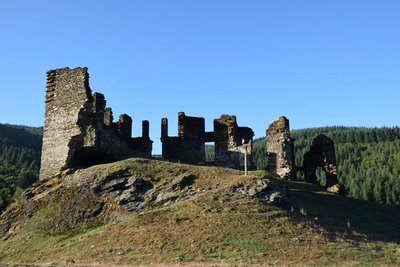
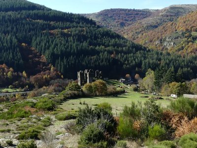
Château de Saint-Julien-d'Arpaon - © com com Florac Sud Lozère HistoryChâteau de Saint-Julien-d'Arpaon
This 13th century castle was the property of the Lords of Anduze, who owned the barony of Florac in what was then the Gévaudan. In 1618, when the Gabriac family owned it, the castle was demolished. In the 18th century, it was inherited by the Montcalm family from Rouergue province, which owned several properties in the Gévaudan. The family restored the building, but it has suffered from effects of time and is currently in ruins – though in a better state of preservation than other castles in the Gévaudan.
Description
From the carpark below the temple (Protestant church), take the path uphill towards the temple, then follow the road to the top of the village. Take the path that runs alongside the Château and go uphill for about 700 m until you reach a lane. Cross it, fork left and go uphill through the heather to the highest point, which is on the western side. Follow the ridge eastwards to the Col de l'Agulharon. Then fork left. Take the lane to Bougès hamlet. As you leave the hamlet, take a downhill path, then a path on the left that runs across the slope, before returning downhill in many hairpin bends to the railway track. Turn right on this track to get back to Saint-Julien-d'Arpaon.
- Departure : Saint-Julien-d'Arpaon
- Arrival : Saint-Julien-d'Arpaon
- Towns crossed : Cans et Cévennes
Forecast
Altimetric profile
Recommandations
Make sure your equipment is appropriate for the day's weather conditions. Remember that the weather changes quickly in the mountains. Take enough water, wear good shoes and put on a hat. Please close all gates and barriers after yourself.
Information desks

Tourism'house and national Parc at Florac
Place de l'ancienne gare, N106, 48400 Florac-trois-rivières
This office is part of the National Park's associated tourist-information network, whose mission is to provide information on, and raise awareness of, the sites and events as well as the rules that must be observed in the National Park's central zone.
On site: exhibitions, video projections, events and shop Open year-round
Transport
Bus stop: mairie
- Bus line 252 Florac – Le Collet de Dèze – Alès.
https://lio.laregion.fr/
Access and parking
From Florac on the N 106 towards the Col de Jalcreste
Parking :
Calculateur d'itinéraire Lio
Utilisez le calculateur liO pour organiser votre trajet en région Occitanie.
Autres régions
Calculez votre itinéraire en Auvergne Rhône Alpes sur Oùra
Biodiversité autour de l'itinéraire
Source


Report a problem or an error
If you have found an error on this page or if you have noticed any problems during your hike, please report them to us here: