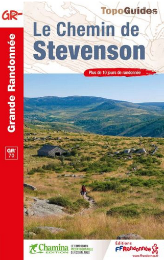
GR®70, the Stevenson trail
Whether you are on your own, with friends or family, on foot, donkey, by bike or on horseback: there are many ways to discover the route taken by Robert Louis Stevenson in 1878. You should allow two weeks for the hike from Le Puy-en-Velay to Alès, the capital of the Cévennes, via the Gévaudan and Mont Lozère. You can then discover the varied scenery and the stories it tells at your own rhythm …
26 points of interest
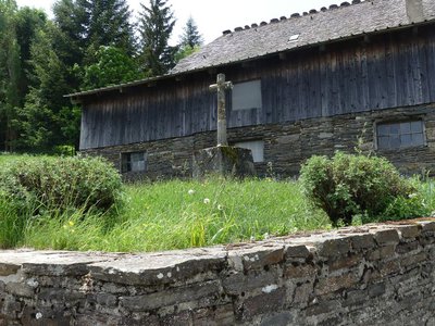
La croix des missions - Nathalie Thomas  History
The “mission” cross
In the municipality of Le Bleymard, there is a large number of crosses and other small religious heritage elements, which bear witness to inhabitants’ fervour in the old days. You will see them as you enter villages, on main squares and at crossroads, to protect the walker and ploughman. Offerings sometimes took the form of crosses, which were then called “mission” crosses.
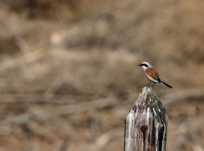
Pie-grièche écorcheur - Régis Descamps  Fauna
FaunaPasserine birds
Open spaces with a few trees and bushes favour passerine birds. Passerines are the largest and most varied order of birds, containing over half of all bird species. The red-backed shrike in particular likes this environment, which abounds in the large insects that constitute its main food source. The shrike is strictly migratory and hibernates in eastern Africa.
Les montjoies - Nathalie Thomas HistoryThe montjoies (cairns)
The "small menhirs" called montjoies that mark out the path did not grow by themselves.... Or rather, their origins were so long ago that nobody remembers. No matter! Look at these boundary markers and imagine for a moment that you are a giant who, after reading Hansel and Gretel, finds himself caught in a tourmente (heavy snowstorm and fog). Wouldn’t you have had the idea of planting a few pointed pebbles two-and-a-half metres high to be able to find your way back?
Finiels - N.Thomas_pnc  Flora
FloraFiniels summit
The short-grass prairie consisting of a coarse grass species called matgrass adapts to harsh weather conditions at altitude. In the spring, wavy snow dunes form in some hollows; small heaps seek shelter behind shrubs. The Eurasian skylark, meadow pipit and common linnet already try to cross the summit by fluttering close to the ground. On the summit itself, some islands of callune (heather, which has the particularity of flowering first at altitude) and some blueberry plants manage, with great difficulty, to establish themselves. Boundary stones have Maltese crosses carved into them. In the 12th century, Baron de Tournel gifted land located on the southern slopes of Mont Lozère to the Knights of Saint-John of Jerusalem. In the 16th century, this order became the Order of the Knights of Malta. The commandery was set up at L'Hôpital and its land delimited by these boundary markers.
Abri forestier - nathalie.thomas FloraThe forest
In the late 19th century, Mont Lozère was almost entirely deforested, largely due to the thousands of sheep that summered here (transhumance). In the early 20th century, reforestation was carried out by locals, who were sowing seeds and planting at the request of the French State, to prevent erosion. This allows us – and deer – to enjoy this “naturally disordered” forest today.
From 1964 onwards, large reforestation programmes were undertaken by companies using machines. The linear and regular layout of these plantations makes them easy to distinguish from older ones.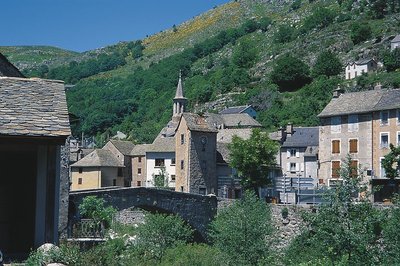
Le Pont-de-Montvert - © Guy Grégoire HistoryPont-de-Montvert
Marker 12
Le Pont-de-Montvert is at the confluence of the Tarn and two of its tributaries: the Rieumalet and the Martinet. The draille (drovers’ road) has today almost disappeared, but it was once used by flocks from the south of France to reach the summer pastures on the Mont Lozère. The first neighbourhoods were established along this axis. In 1630 the village was almost as extensive as in the early 19th century. Three stone bridges were built over the rivers, but the great floods of 1827 and 1900 seriously damaged or destroyed them. The grand Tarn Bridge is the only stone bridge still standing. New neighbourhoods developed on the village’s periphery, preserving the historic centre.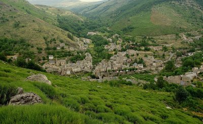
Chemin des camisards - © Brigitte Mathieu HistoryThe Camisards' path
Marker 11
This path used to be an important communication route linking Le Pont-de-Montvert with Barre-des-Cévennes. On 24 July 1702, it was used by a gathering of Huguenots coming from the Col des Trois Fayards, who intended to liberate their fellow Protestants being held by Abbot du Chayla in Le Pont-de-Montvert. These men thus used the path on which you stand. The tragic events that followed (including the Abbot’s violent death) triggered the Camisard War. The landscape surrounding the village is the result of intense agricultural activity. All neighbouring slopes were cultivated, especially with rye, on man-made terraces called bancels.
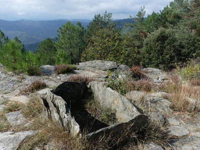
 Geology
A rolling stone...
Marker 10
On the plateau, the path has not always made a very distinct mark on the ground, evidence of little erosion. By contrast, the entire descent towards Le Pont-de-Montvert shows signs of more intense erosion, especially near the top where a large block has rolled into the middle of the path. It is the repeated passage of humans and animals that, combined with natural factors, eventually destabilised the rock. After the rock moved, the path was re-routed. Architecture
Sheepfold with lauze-covered roof
Marker 9
Unlike the previous sheepfold, this one was built out of heavy, compact and solid materials. A granite vault instead of a timber roof suggests the rarity of wood. The roof was made watertight by schist lauzes (tilestones) on a bed of clay or coarse granite sand. This place is called La Jasse de Chanteloup (jasse/jas: resting place for animals; canteloube in popular etymology = place where the wolves howl, or, according to scholarly sources, luppe = stone, height, rounded mountain). Landscape
Panorama
Marker 8
Views of the southern slope of Mont Lozère- Architecture
A sheepfold in ruins
Marker 7
You need to leave the path on the left and walk for about 200 metres to see this former shelter for farm animals (ovines and bovines). The materials for its construction were found locally: granite for the walls, Scots pine or oak for the timber part of the roof, rye thatch for the roof. The variety of rye grown locally had fine long straw. It was cut by scythe at the end of July and put into swathes, then stored in stacks and threshed on threshing-floors. Finally it was made into small sheaves, which were soaked before use to make the last seeds germinate and make the straw less breakable during thatching. 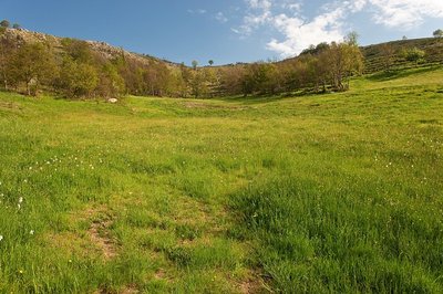
Prairie vers l'Hermet - © Guy Grégoire  Natural environment
Heath alternating with hay meadows
Marker 6
Callune has established itself on the knolls, meaning the convex areas which have poor and dry soils, whereas the meadows occupy the concave areas with their deeper and damper soils. All of these territories offer food sources for specific fauna. You may see hares, but also birds of prey (buzzards, hen and Montagu’s harriers, short-toed snake eagles, common kestrels) and red-legged partridges.- Fauna
Pine-forest fauna
Pine forests associated with blueberry zones are interesting environments for fauna: stags and roe deer come to browse the blueberry plants. Wild boar, foxes, martens and all birds eat their berries, including the Western capercaillie, which was reintroduced here by the National Park. You can also find coal tits, European crested tits, wrens, robins, mistle thrushes and black woodpeckers. Some birds of prey, such as the short-toed snake eagle, may come and build their nests at the highest point of a topped Scots pine.
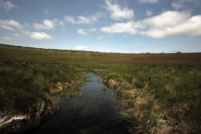
Source du Tarn - © Yannick Manche  Water
WaterThe river Tarn
The Tarn has its spring at an altitude of 1,550 m under the ridge of Mont Lozère. Having carved its way into the granite bedrock, it separates the Bougès massif from Mont Lozère. After Bédouès, it meets the river Tarnon and slowly enters the limestone region, in which its bed is increasingly deep. At its confluence with the Jonte, at Le Rozier, the Tarn leaves the department of the Lozère.
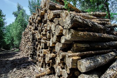
coupe de bois - © Olivier Prohin  Know-how
Fages Sawmill
Upstream from Bédouès, you will see a sawmill, which mainly produces wood to make crates and pallets. It also produces some timber. Today, local forestry companies utilise wood in a number of ways: for energy, paper pulp, timber, crate-making and construction.
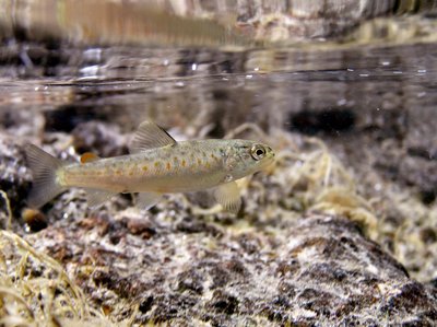
Truite fario - © Philippe Baffie FaunaThe brown trout (Salmo trutta fario)
This trout lives in our waterways and is an indigenous species. This stock is a part of our heritage. Its size varies with the quality of the water, fishing pressures, and the nature of the riverbed (hiding-places). In the summer, it hunts in white water and on the surface, and catches insects. In the winter, it eats larvae on the bottom. Reproduction begins in November and is staggered throughout the winter. The female lays its eggs on a gravelly stretch of the riverbed, into which it has dug a pit using its caudal fin. The male deposits its milt over the eggs. Once they are fertilised, the eggs are covered with gravel. Reproductive success depends on variations in the water flow and especially on the risk of the spawning areas drying out in dry winters.
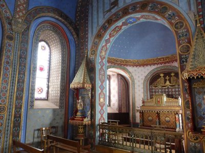
Chapelle St-Saturnin - © Nathalie Thomas HistorySaint-Saturnin chapel
Saint-Saturnin chapel stands at the heart of the village, surrounded by its cemetery. Inside every wall boasts a magnificent painted décor. It was built in the 12th century. Guillaume de Grimoard (the future Pope Urban V) was baptised here in 1309. It is next to the town hall (mairie) and is well worth a detour.
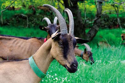
Chèvre de race alpine - © Olivier Prohin AgricultureThe Gautier goat farm
Yolande and Christian run a small farm where they make farmhouse goat's cheese, a typically Cévenol product. Their herd consists of 60 Alpine dairy goats, and all their milk is processed on-site into farmhouse cheese. From late November to late April, the nanny goats have a break so their little ones can feed!
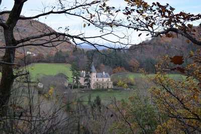
Château d'Arigès - © com com Florac Sud Lozère HistoryChâteau d’Arigès
This can be seen on your left, in a gap in the forest. It was only a share-cropping farm, whose buildings were in ruins, when the Lord of Issenges bought it in 1658. He lived in it from 1688. This Château, which is no doubt more comfortable than the « maison carrée » (“square house”), was built in a river bend of the Tarn and is surrounded by fertile soils well-suited for crop-growing.
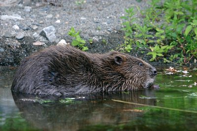
Castor au réfectoire - © Bruno Descaves FaunaThe European beaver (Castor fiber)
The calm deep stretches of the Tarn are good areas to settle for the European beaver, which lives in a lodge dug into the river bank. An essentially vegetarian animal, it bases its diet on cellulose. It eats young shoots, bark, aquatic plants, and foliage that is abundant in the riparian forest. It is thus useful in regulating the woody vegetation of river banks, facilitating the development of riverside fauna and flora. Through its activities, it prevents the potentially dangerous accumulation of dead wood during floods. It does not build dams.
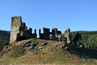
Château de Saint-Julien-d'Arpaon - © com com Florac Sud Lozère HistoryChâteau de Saint-Julien-d'Arpaon
This 13th century castle was the property of the Lords of Anduze, who owned the barony of Florac in what was then the Gévaudan. In 1618, when the Gabriac family owned it, the castle was demolished. In the 18th century, it was inherited by the Montcalm family from Rouergue province, which owned several properties in the Gévaudan. The family restored the building, but it has suffered from effects of time and is currently in ruins – though in a better state of preservation than other castles in the Gévaudan.
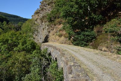
Pont sur le CéFéDé - © com com Florac Sud Lozère HistoryThe CFD (mountain-bike route)
Users and employees still talk of the former railway (CFD) with regret and emotion:
“To go to Montpellier on Mondays, I could leave at 6 in the morning, and arrive in Montpellier at 10, and you could get back here in the evening. The train arrived at 10 o'clock in the evening. Now (with the coach), you can go down, but you have to wait for the next day to come back up. It was very useful. Nowadays, if you don't have a car, what do you do? You hitch-hike, you walk!” (P. Grime)
“Two years after the train was shut down, we had the idea of putting it back on the track and turning it into a tourist train. We managed to get a railcar to start... We hadn't told anyone: apparently we didn't have the right to do it, we even risked getting a correctional sentence. Nothing happened... Except that at St-Julien-des-Points we gave a blast of this kind of horn that we had, and M., from the restaurant, came up with a litre of pastis, and two or three farmers from the area arrived too. We all cried like babies. We had the impression that the heart of the area was beating again.” (Revue Cévennes, issue 15)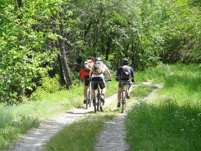
CFD - © Cévennes Evasion HistoryThe disused railway (CéFéDé)
From 1909 to 1968, this railway line linked Florac and Sainte-Cécile-d'Andorge (50 km). A metre-gauge single-track line, it was managed by the department's railway company. It was linked to the SNCF state railway network. The trains transported passengers and merchandise: ore from Ramponenche mine near Florac; baryte from the mine at Jalcreste, and plums, chestnut wood, dried boletus mushrooms, etc., destined for northern France. As you move along the disused line, you will see former engineered constructions (bridges, tunnels, etc.).
Sépulture à coffre - nathalie.thomas  Archaeology
Menhir (standing stone)
At the pass is a standing stone or menhir, a schist slab 1 ½ m high and 80 cm wide, which has circular depressions known as cup marks and carved rods. Many vestiges attest to the presence of humans in the schist valleys of the Cevennes as of 3,000 BC: tombs, menhirs, carved marks. Some 15 menhirs have been inventoried in the Gardon valleys. They are not grouped together but located on ridges or at passes. Their meaning remains very unclear: landmarks for orientation, symbols linked to worship, territorial markers, etc.?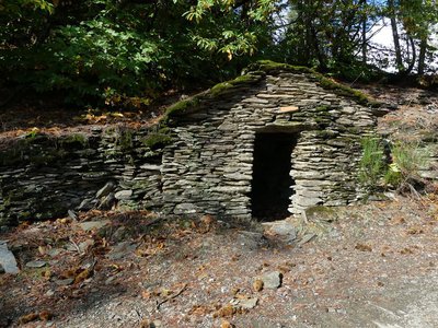
Cabane du cantonnier - nathalie.thomas HistoryThe King’s road
You walk past a little building that used to house the roadmender’s tools. The path you take is the former King’s road between St-Germain-de-Calberte and Barre-des-Cévennes, which was rebuilt in the early 17th century on the orders of the Intendant of Languedoc, tasked with repressing the Camisard uprising. The King’s roads allowed royal troops to penetrate into areas where movement was very difficult. This road is built on supporting walls and, in some sections, carved into the rock.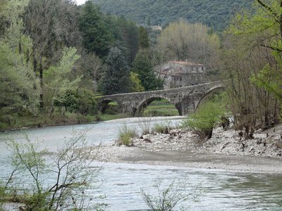
Le pont des Camisards - nathalie.thomas HistoryThe Pont des Camisards
Legend has it that this humpback bridge was built from 1702 to 1704 by Jean Cavalier, a leader of the Protestant Camisard uprising against the Catholic King. And a legend is all it is. It was constructed a decade later, from 1714 to 1718, when Louis XIV's Intendant, a Monsieur de Basville, decided to develop the road network in the Cevennes. The diocese of Alès was responsible for funding a large share of the construction, and the inhabitants of Mialet were forced to participate through work our paying taxes. In 1976, it became a listed monument. (Nelly Bernard)
Description
Only the section of this GR® [long-distance hiking path] which crosses the territory of the Cévennes National Park, from Le Bleymard to the outskirts of Alès, is described here.
You can find the entire itinerary in the topographic guidebook “Le Chemin de Stevenson” (ref. 700), published by the French hikers’ federation Fédération française de randonnée pédestre and available for purchase in the Maisons du tourisme et du Parc [joint tourist office and National Park information centre], the online shop at www.cevennes-parcnational.fr, bookshops, sports shops and at https://boutique.ffrandonnee.fr.
All information is also available on the website of the association “Sur le Chemin de Robert Louis Stevenson”: www.chemin-stevenson.org
- Departure : Le Bleymard
- Arrival : Alès
- Towns crossed : Langogne, Luc, Laveyrune, La Bastide-Puylaurent, Mont Lozère et Goulet, Cubières, Pont de Montvert - Sud Mont Lozère, Cassagnas, Cans et Cévennes, Florac Trois Rivières, Bédouès-Cocurès, Saint-Martin-de-Lansuscle, Saint-Germain-de-Calberte, Saint-Étienne-Vallée-Française, Saint-Jean-du-Gard, Mialet, Saint-Sébastien-d'Aigrefeuille, Saint-Paul-la-Coste, Saint-Jean-du-Pin, Cendras, and Alès
Forecast
Altimetric profile
Recommandations
NB: For various reasons, the waymarked path may differ from that shown in the topographic guidebook: please follow the waymarks on the trail. Make sure your equipment is appropriate for several days of hiking as well as the day’s weather conditions. Remember that the weather changes quickly in the mountains. Take enough water, wear sturdy shoes and put on a hat. Please close all gates and barriers behind you.
Information desks

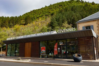
Tourism'house and national Parc at Florac
Place de l'ancienne gare, N106, 48400 Florac-trois-rivières
This office is part of the National Park's associated tourist-information network, whose mission is to provide information on, and raise awareness of, the sites and events as well as the rules that must be observed in the National Park's central zone.
On site: exhibitions, video projections, events and shop Open year-round

Tourism office Cévennes Tourisme, Saint-Jean-du-Gard
Maison rouge, 30270 Saint-Jean-du-Gard
This office is part of the National Park's associated tourist-information network, whose mission is to provide information on, and raise awareness of, the sites and events as well as the rules that must be observed in the National Park's central zone.
Open year-round

Tourism office Des Cévennes au mont-Lozère, Le Collet-de-Dèze
RN 106, 48160 Le Collet-de-Dèze
This office is part of the National Park's associated tourist-information network, whose mission is to provide information on, and raise awareness of, the sites and events as well as the rules that must be observed in the National Park's central zone.
Open year-round

Office de tourisme Des Cévennes au mont Lozère
le Quai, 48220 Le Pont de Montvert sud mont-Lozère

Mairie, 48250 La Bastide-Puylaurent

Place de l'église - Le Bleymard, 48190 Mont Lozère et Goulet
Transport
- Ligne 282 Mende - Langogne - Le Puy en Velay
- Ligne 253 Mende - Bagnols les bains - Mont Lozère.
- Ligne 261 Florac - Le Pont de Montvert - Mont Lozère
- Ligne 252 Florac - Alès
- Ligne 251 Florac - Mende
- Ligne 112 et 142 pour aller de Saint-jean du gard à Alès
- https://www.lio-occitanie.fr
Calculateur d'itinéraire Lio
Utilisez le calculateur liO pour organiser votre trajet en région Occitanie.
Autres régions
Calculez votre itinéraire en Auvergne Rhône Alpes sur Oùra
Biodiversité autour de l'itinéraire
Source


Report a problem or an error
If you have found an error on this page or if you have noticed any problems during your hike, please report them to us here: