The Tarn gorge from Florac to Le Rozier (GR®736)
The Tarn gorge – there is more to discover! The path, on the left bank of the Tarn, is an invitation to get out of your vehicle and head off on foot along the river to explore the canyon’s villages and scenery at leisure.
19 points of interest
PROHIN Olivier  History
The Esplanade
The covered passage of the sub-prefecture is one of several in Florac, running beneath the houses. You have just gone through the former town wall and now find yourself inside the medieval town. Besides the beautiful ancient plane trees (the oldest are 200 years old), you can see, at one end, the statue of Léon Boyer, who built the Garabit viaduct with Gustave Eiffel and died in 1883 in Panama, where he was working on the construction of the Canal; and at the other end, the temple (Protestant church) and the War Memorial.
PROHIN Olivier HistoryThe Planet neighbourhood
In the 16th and17th centuries, a large number of religious conflicts between Catholics and Protestants affected the Cévennes, bringing with them much destruction. After the Peace of Alais was signed by Richelieu and the Duke of Rohan in June 1629, Protestants retained the right to practise their religion, but their fortifications were razed. This included Florac's town walls. The house bearing this information panel is one of the town's oldest: its tower used to watch over Thérond Gate. It also stands at the crossroads of the former road linking Nîmes with Saint-Flour and the former road from Florac to Séverac via the Causse plateau.

 Geology
The iron-rich water of Salce
After a small detour from the hamlet of
Salièges to the river Tarn, you will come across a spring of ferruginous water. For a long time, the ability to prevent (or cure) alcoholism was attributed to this water rich in Fe2+ ions, and made famous by a sketch by the stand-up comedian Bourvil. It supposedly supplies the iron that would normally come from regularly drinking alcohol. A small construction indicates the Salce spring (the path from Salièges is way-marked), as does the red tinting from iron oxide, which you find in many contact zones between schist and limestone.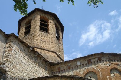
Chevet de l'église d'Ispagnac - cevennes-gorges-du-tarn  Architecture
Ispagnac church
St-Peter’s Church in Ispagnac is one of the finest examples of Romanesque architecture in Gévaudan. Built in the 12th century, it is dedicated to Saint Peter and Saint Paul. The understated facade of this bulky-looking building has a simple gate with three semi-circular arches topped by a rose window that lets light into the nave. Once inside, you discover a simple and airy architecture. A sound-and-light show helps you to explore. To get the fullest impression of the architecture, you need to leave the building and walk around it to see the apse and its décor.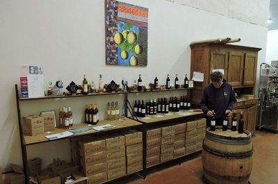
La cave viticole d'Ispagnac - cevennes-gorges-du-tarn AgricultureThe vintners of Ispagnac
In 2003, Sylvain Gachet, from Savoy, reintroduced grapevines to Ispagnac and Florac, planting six hectares of terraced land. On soils of clay/limestone and schist, he attempted to breathe new life into the Domaine de Gabalie. In 2006, Elisabeth Boyé and Bertrand Servières set up as vintners in the Tarn gorge, also under the stimulus package bringing vineyards back to the valley. They cleared the land of the bartas (brambles) which had invaded almost all the parcels, and rebuilt the dry-stone walls before planting almond trees, vine peaches and five hectares of grapevines: the Domaine des Cabridelles was born. The winemakers share a cooperative cellar in Ispagnac, which is also a sales outlet. Why not make a short stop to try the wines (the cellar is next to the car park by the state school (école publique).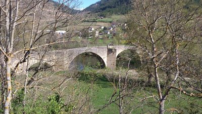
Pont de Quézac - © CC Florac Sud Lozère ArchitectureQuézac Bridge
This bridge crossing the river Tarn gives access to the village of Quézac, located on the left bank. Around 1350, Pope Urban V decided to fund its construction to facilitate pilgrims' access to the collegiate church of Notre-Dame de Quézac. It was finished in the 15th century. Its history is punctuated by partial destruction in floods, and by more or less solid rebuilding. It became a listed monument on 27 August 1931.
Source de Quézac - © Nathalie Thomas  Water
WaterQuézac mineral water
Quézac mineral water emerges naturally from the Diva spring, near the entrance to the village, in exceptional surroundings which have been naturally protected for centuries. This pleasant-tasting water is rich in mineral salts and trace elements and is also well-known to be beneficial for the stomach. The spring's water actually comes from Mont Aigoual. According to scientific studies, it takes 30 to 40 years for it to re-emerge in Quézac, after first settling in aquifers, where it acquires its effervescence naturally (rare in France).
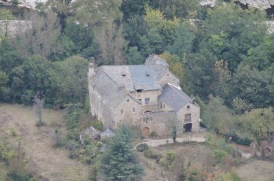
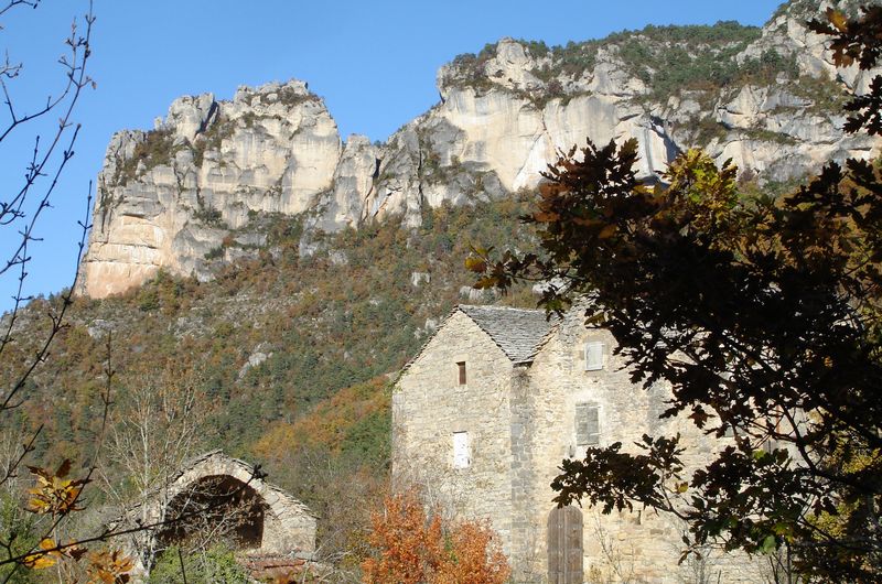
Château de Charbonnières. - © OTGCC nc ArchitectureThe Château de Charbonnières
In a bend of the Tarn downstream from the village of Montbrun stands the Château de Charbonnières. While the former castel has lost some of its defensive elements, it has nevertheless preserved a knightly characterand traces of many historical episodes of the Tarn valley. It is first recorded in the 13th century. Its defensive role was tightly linked to a whole “fortified system” downstream of Ispagnac, which consisted of Quézac, Javillet, La Roche, Rocheblave, Montbrun, Castelbouc, Prades and Sainte-Enimie.
The château has three rectangular //buildings arranged in a horseshoe shape around an internal courtyard. The facade overlooking the Tarn has a square tower that dominates the river. Access to the internal courtyard is via gates under a semi-circular arch. From the courtyard, a stone staircase leads up to the chapel, whose doorways is decorated with fleur-de-lys. The modest interior has a ribbed vault framing a keystone engraved with the arms of the Montesquiou family, lords of Charbonnières from the 13th century onwards. The other parts of the residential building have handsome fireplaces, a monumental staircase and fine vaulted halls. In the 17th and 18th centuries, the château became the property of the Volonzac Malespina family and, in the 19th century, of the Boutin family. It is not open to the public.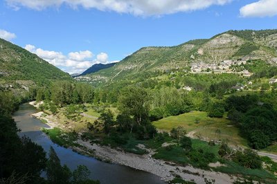
Les gorges du Tarn et le village de Montbrun - BOUISSOU Arnaud / TERRA Ministère de l'Environnement WaterNot always a docile river!
For 52 km, from the point it enters the canyon at Quézac to Le Rozier, the Tarn has no overground tributary. However, it is fed by about 170 karst springs stemming from subterranean aquifer networks. These springs release the rainwater absorbed by the avens, dolines and fissures of the Causses plateaux. When reserves are high, the water gushes with great force from the karst environment. Locals say that “the corks are popping”. In the event that the tributaries of the Tarn (the Mimente and Tarnon) rise and add to the springs, the time will have come to move the furniture upstairs.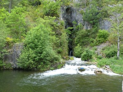
Résurgence de Castelbouc - © N Thomas WaterThe spring of Castelbouc
The vast spring as you enter the hamlet has four outlets, including one at the back. These openings, out of which water surges during heavy rain, reinforce the translation of the Occitan bouc as bouches (“mouths”). All springs are fed by a catchment area of varying size. Here, the catchment area is the sector of Aven du Pic de l’Usclat, Aven du Loup (Cros garnon) and Aven du Crapaud (Fretma) on the Causse Méjean plateau.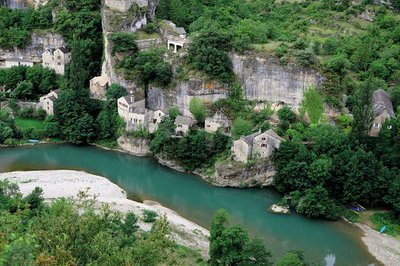
Castelbouc - B Daversin HistoryThe strange legend of Castelbouc
For you to judge…
The etymology of Castelbouc is castel blanc, meaning “perched on the rock” in Occitan.
Legend has it that during the Crusades the castle’s lord was the only man to have remained behind in this little hamlet of dwellings built against the cliff. He had many female visitors, and it was important to him to satisfy their needs. Unfortunately, the Crusade was so long that he was unable to keep going to its end. When his soul left his body, an enormous he-goat was seen hovering over the castle tower… Ever since, a bleating sound followed by strange murmurings can be heard on the summit. This is the legendary origin of the name of Castelbouc...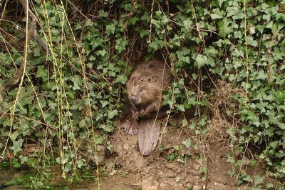
Castor - © OTGCC nc  Fauna
FaunaThe beaver
Proof that I have been here might be a tree carved into a pencil shape; pieces of bark; wood chips; a heap of branches in the water; back or front paw prints in the sand. I’m the Eurasian beaver. I live near water. I’m active mostly at night, and sometimes at dawn and dusk if no-one disturbs me. From the Middle Ages (11th century) to the 19th century, times were hard for us. We were hunted by humans for our flesh, fur and because we were thought a nuisance. In the early 20th century, we had disappeared from many parts of France. Today, things are better – we live alongside and in the Tarn again.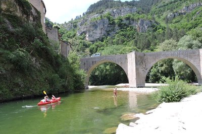
Le Pont de Ste-Enimie - © OTGCC nc HistoryThe bridge
Finally a bridge over the Tarn!
In the 13th century, the Benedictine monks of Sainte-Énimie built a bridge to replace the ford, or possibly a previous, more precarious construction. The new bridge linked Sainte-Énimie to the Causse Méjean plateau, where the Benedictine community owned land. Commerce and trade with Lower Languedoc (wool, woven products, wine) boomed. The village soon became an essential point on the important pilgrim route linking Le Puy-en-Velay with Aniane, via Saint-Guilhem le Désert. In the Middle Ages, it was rare to find so many bridges that could be crossed with carts and other large means of locomotion. The monks were true visionaries: today, the bridge is the only access to the Causse Méjean from the Tarn gorge that is authorised for buses and lorries weighing more than 19 tonnes (on the D986 linking Mende with Meyrueis).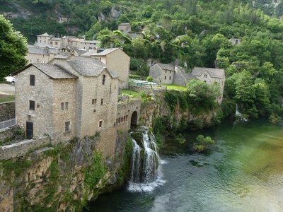
Saint-Chély du Tarn - nathalie.thomas HistorySaint-Chély du Tarn
Saint-Chély-du-Tarn benefits from the three ideal conditions for founding a village: ample springs; construction materials (tuff rock) available on site; and, above all, a track connecting it to the Causse Méjean plateau. All the gorge hamlets are linked to the Causse by a path. Over time, these connecting paths were developed to varying extents – cobbled and/or consolidated by small walls – and they facilitated trade.
Le château de La Caze - nathalie.thomas HistoryThe Château de La Caze
The Château was built in 1489 as a wedding present for Soubeyrane d'Alaman, the niece of the Prior of Sainte-Enimie. With its four corner towers, it is now a hotel. Tradition tells a ribald story about the eight daughters of a former owner. Beautiful and mischievous, they believed in smooth talking and free love. It is said that “their souls are condemned to wander and sigh all night in this dark gorge for want of satisfaction".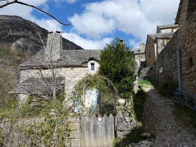
Hauterives - nathalie.thomas HistoryHauterives
This hamlet was built in an amphitheatre shape above the (now ruined) mill so as to save on farm land. The mill would have been a convivial spot and the fundamental economic link between the plateau and the valley. Here the plateau’s grains were exchanged for legumes, grapes and almonds grown on the well-sited terraces that are still visible today. The mill and dam were carried off by the once-in-a-century flood of 1900. When the road was opened in 1905, Hauterives refused permission for the construction of a bridge. Currently a cable car makes it possible to transport goods and other objects. Access for inhabitants is by boat.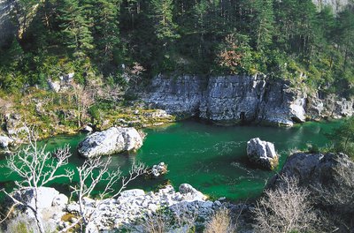
Gorges du Tarn - © Guy Grégoire HistoryThe boatmen of La Malène
“La Malène” means “bad hole”... But for several decades now, it has been more accurate to call it a little jewel that delights tourists. What is its secret? Using the boats which were once strictly utilitarian, back in the days when the Tarn was a transport and trade route! On 29 December 1952, the Cooperative Society of Boatmen of the Gorges du Tarn was officially created. In 1985, the Cooperative became a Worker Cooperative. Once on the water, the boatmen will help you discover sites that can only be seen and approached by boat, such as La Momie Cave, or the Woman with a Parasolrock formation above La Croze. That's at least two good reasons to treat yourself to this journey by water accompanied by the boatmen of La Malène.
- History
Little anecdote
"Traditionally, a hillclimbing race is held in this small town on the first Sunday in July. The first races were goat races. Marthe marshalled her goats at the bridge, climbed the slope of La Canourgue by herself and then called to them from up there. The goats ran to her. The winner was rewarded with a fragrant bouquet of bartas (box)." (M.P Leroy-Delmer)
- History
Chapel
"300 m from the hamlet, the ruins of the Château de Planiol dominate a flat area (planiol) of the river, which is 8 m deep here. Then the Romanesque 12th century chapel appears, probably built on the site of a Carolingian oratory. An 'expiatory chapel' has been added, which contains the remains of the martyrs of La Malène. Another chapel is occupied by the Virgin Mary standing in a boat. It is brought out every May for the boatmen's pilgrimage. As for the bridge, it was built in 1856 in the place of a former ford crossed by the Esperelle draille (path for seasonal livestock migration). Because of its scant height, it did not survive the devastating floods of 1875 and 1900.” (M.P Leroy-Delmer)
Description
Day 1: Florac - Ispagnac 10 km, 330 m +
Day 2: Ispagnac - Sainte-Enimie 17,5 km, 433 m +
Day 3: Sainte-Enimie - La Malène 14,2 km, 686 m +
Day 4: La Malène - Les Vignes 12,7 km, 592 m +
Day 5: Les Vignes - Le Rozier 12 km, 435 m +
Suggestion for three days: day 2, days “3+4”, day 5, with the possibility of shortening the Ispagnac/La Malène section, by doing it with the bateliers (boat people) of La Malène in one of their boats: +33 (0)4 66 48 51 10 (reservation and information).
1- Florac to Ispagnac / 10 km, 330 m + : GR®736
From Place de l'Esplanade, take Rue du Thérond, then Avenue du 8 mai 1945 towards the hamlet of Salièges. As you leave Salièges, continue on the track suitable for motor vehicles to Ispagnac, passing through these consecutive small hamlets: Salièges, Le Fayet, Bieisses, Bieissettes (GR®670).
2- Ispagnac to Montbrun Bridge / 7.2 km, 188 m+ : GR®736
Go down Rue des Barrys to the campsite, walk along the Tarn river, cross the bridge and go right through Quézac. After the village, continue for 1.5 km on a lane to pick up the path again. The path – which either overhangs the river or runs along the bank – goes deeper into the canyon, passes the perched village of Montbrun and reaches Montbrun Bridge over the Tarn.
3- Montbrun Bridge to Castelbouc / 3.3 km, 124 m+ :
Follow the small road on the left bank. This passes above the manor of Charbonnières to reach, a little further on, one of the most unusual sites of the Tarn gorge: the hamlet of Castelbouc, nestled under the cliffs.
4- Castelbouc to Sainte-Énimie / 7 km, 121 m+ :
Go through the hamlet. At the square in front of the bread oven, take the lane on the right and after the small bridge follow the path on the right that heads towards the riverbank. This part of the walk is in the shade of large trees and has views over the Château de Prades. The valley gets narrower before coming out onto the mediaeval village of Sainte-Énimie.
5- Sainte-Énimie to Saint Chély du Tarn / 5 km, 277 m+ : GR®736
Cross the bridge, direction Meyrueis. Turn left in front of the hotel, then left onto the road which goes uphill to some detached houses, then overhangs the D986 before joining up with it. 250 m later take the path on the right. As soon as you leave Sainte-Enimie, the path gains in height, climbs above the cliffs and then goes back down in zigzags to the village of Saint-Chély du Tarn.
6- Saint-Chély du Tarn to La Malène / 9.2 km, 409 m+ : GR®736
Take the road which goes up toward the Causse plateau and, after a hairpin bend, turn right at a crossing. The first section of the path is above the cliffs; then it goes downhill to the riverside. You have views onto the troglodytic village and cirque of Pougnadoires. The path goes back uphill, passes a rocky promontory, goes downhill near the Château de La Caze and then continues on an overhang to Hauterives. After one more section above the cliffs, you arrive at La Malène along the river.
7- La Malène to Les Vignes/ 12.7 km, 592 m+ : GR®736
At the bridge, turn right onto the track suitable for motor vehicles for 3.5 km, then take the path. La Malène is overlooked by a cliff marked by long black streaks. The village is famous for its bateliers (boat people), who have ensured that the traditional descent of the canyon’s narrowest part, by small boat, survives. Until you reach the village of Les Vignes, the path crosses only one hamlet (La Croze, private property). This is the most celebrated section of the canyon, with spectacular scenery: the straits, the Cirque des Baumes, the Pas de Souci. (La Malène – the Cirque des Baumes with the bateliers: 8 km on the river, as a passenger. You can pick up the Tarn gorge path again afterwards; the bateliers will explain how).
8- Les Vignes to Le Rozier / 12 km, 435 m+ : GR®736
Take the road leading up to the Causse Méjean and, after 800 m, the path on the right. At the start, you have magnificent views onto the series of cliffs of the Causses Sauveterre and Méjean. The whole walk is overlooked by the cliffs, at whose feet nestle semi-troglodytic hamlets (you can see St-Marcellin and Eglazines, on the right bank). The path goes above La Sablière, a hamlet with typical architecture (a panel indicates whether it can be visited) and reaches Le Rozier by an easier path.
- Departure : Florac
- Arrival : Le Rozier
- Towns crossed : Florac Trois Rivières, Gorges du Tarn Causses, Ispagnac, La Malène, Massegros Causses Gorges, Saint-Pierre-des-Tripiers, and Le Rozier
Forecast
Altimetric profile
Recommandations
(/!\ Caution during spring and autumn floods: information from tourism offices or at www.vigicrues.gouv.fr (area: Garonne-Tarn-Lot / Haut Tarn-Montbrun).
Make sure your equipment is appropriate for the day’s weather conditions. Remember that the weather changes quickly in the mountains. Take enough water, wear sturdy shoes and put on a hat. Please close all gates and barriers behind you.
Information desks

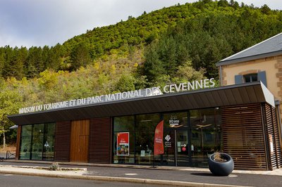
Tourism'house and national Parc at Florac
Place de l'ancienne gare, N106, 48400 Florac-trois-rivières
This office is part of the National Park's associated tourist-information network, whose mission is to provide information on, and raise awareness of, the sites and events as well as the rules that must be observed in the National Park's central zone.
On site: exhibitions, video projections, events and shop Open year-round
Transport
Car park in front of the old train station
Bus line Florac-Mende
Daily year-round bus line, Monday to Saturday morning (except bank holidays)
https://www.cevennes-gorges-du-tarn.com/bus-ales-florac-mende
Bus line Florac-Ste-Enimie-Le Rozier, July and August, every day
https://lio.laregion.fr/IMG/pdf/oc-1903-fhbus-48-258-3v_bd_04_.pdf
Bus line Alès-Florac (by reservation only if starting from Ispagnac), Boulet: +33 (0)4 66 65 19 88
Daily bus line except Sundays and bank holidays, from 15 April to 31 October.
https://fr.calameo.com/read/003034667db3a5b1c0788
Bus line Meyrueis-Le Rozier-Millau, July and August
https://lio.laregion.fr/IMG/pdf/oc-1903-fhbus-48-257-3v_bd_04_.pdf
Daily-year round bus line. Different times depending on school holidays or not.
Line 215 Autocars Causse: + 33 (0)6 65 61 24 16
Access and parking
RN106 Florac
Parking :
Calculateur d'itinéraire Lio
Utilisez le calculateur liO pour organiser votre trajet en région Occitanie.
Autres régions
Calculez votre itinéraire en Auvergne Rhône Alpes sur Oùra
Biodiversité autour de l'itinéraire
Report a problem or an error
If you have found an error on this page or if you have noticed any problems during your hike, please report them to us here: