
The secret ravine of Champernal
8 points of interest
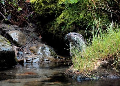
Loutre d'Europe - © Regis Descamps  Fauna
FaunaBrook fauna
The otter was once much coveted and hunted for its pelt. Over 30 years passed before it settled in the waterways of the Cévennes again. Since then, its presence in the National Park has been well-known through monitoring of its tracks and other indicators. The population of white-clawed crayfish, on the other hand, is shrinking; it is very sensitive to environmental variations. To preserve it, habitat diversity and especially water quality are key.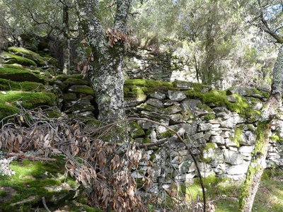
Bancels - nathalie.thomas AgricultureBancels (crop terraces)
“They used to have their gardens over there, in Cessenade, they planted tomatoes, beans… because the village wasn’t hooked up to the water mains yet. The bancels were walled in to keep back the soil, with an opening just large enough for one man and his load of manure, they carried everything on their backs, even a mule couldn’t get there… Back then, there was so much to do that on evenings when the moon was full, they would repair the low walls, and there were people, this is really long ago, who took on a labourer to help them and they paid him with two or three basketfuls of soil that he would take back to his own bancels.”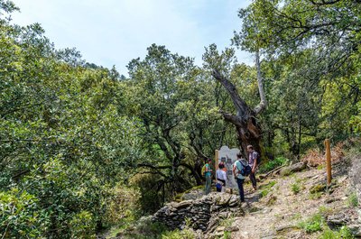
Un hôtel accueillant - Olivier Prohin  Natural environment
A welcoming place to stay
This chestnut tree and the ruined clède (chestnut-drying building) are the relics of a chestnut grove that was abandoned long ago.
The tree is dead… but full of life. National Park rangers take part in the national inventory of saproxylic beetles (which eat dead wood). Trapping, observing and identifying the species are the key stages of this work. The known reproductive and over-wintering sites of bats, which are victims to habitat loss and light pollution in particular, are also counted.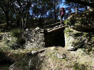
Béal - nathalie.thomas AgricultureThe béal (irrigation channel)
On large slabs of stone, the path straddles the béal which irrigates the crop terraces, and whose starting-point is 1.5km upstream.
“I know that several people had a right to the béal, and they each had their day to use the water. Where I lived there were at least 3 kilometres of béal, and to maintain them, we’d work in March and autumn. Nowadays you can water the parcels with a hose but it doesn’t distribute the water like a béal. When there were channels everywhere, everything was green, now it’s all dry”.
Olivier Prohin AgricultureCultivated chestnut trees
These can be spotted by their bulge, which is the scar left by grafting. Here, you can see the chestnut tree in various forms: as a stand that is wasting away, in a maintained orchard (in front of you) or mixed with pine or holm oak (behind you).
The comballe variety predominates in this area but many other varieties are grown in the Cévennes, thus guaranteeing a long harvest period and better resistance to diseases, insects and climate whims.
Vue sur le viaduc de Cessenades - Olivier Prohin  History
The departmental railway (CFD)
Inaugurated in 1909, the departmental railway (CFD) linking Florac with Sainte-Cécile d’Andorge required 15 tunnels and 53 road and rail bridges. It was closed down in 1968 for lack of profitability. The line is being progressively turned into a walking and cycling path, which offers picturesque views over the meanders of the rivers Mimente and Gardon d’Alès (Vallée Longue).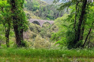
Vue sur le viaduc de Cessenades - Olivier Prohin Natural environmentA wild ravine
The spectacular Cessenade railway bridge reveals the depth of this natural ravine, which is difficult to access. Its configuration and microclimate have encouraged a varied wildlife and the preservation of a very particular association of lichens, ferns, mushrooms and mosses. The steep sides of the ravine have helped to preserve a previous afforestation. Other forests in the National Park are deliberately left to evolve naturally. Long-term studies of these help us to better understand the natural phenomena that transform forests.
Evolution de la forêt - Olivier Prohin Natural environmentThe hidden side of the ravine
Alongside the former railroad, the forest is spontaneously evolving towards more diversity and maturity. After broom and heather come pine and birch. These stands enrich the soil with organic matter and prepare the arrival of true forest: holm oak, chestnut and then downy oak, all species that grow slowly and are ecologically demanding.
Description
- Departure : Champernal bridge
- Arrival : Champernal bridge
- Towns crossed : Saint-Privat-de-Vallongue and Ventalon en Cévennes
Forecast
Altimetric profile
Recommandations
Information desks

Tourism'house and national Parc at Florac
Place de l'ancienne gare, N106, 48400 Florac-trois-rivières
This office is part of the National Park's associated tourist-information network, whose mission is to provide information on, and raise awareness of, the sites and events as well as the rules that must be observed in the National Park's central zone.
On site: exhibitions, video projections, events and shop Open year-round
Tourism office Des Cévennes au mont-Lozère, Le Collet-de-Dèze
RN 106, 48160 Le Collet-de-Dèze
This office is part of the National Park's associated tourist-information network, whose mission is to provide information on, and raise awareness of, the sites and events as well as the rules that must be observed in the National Park's central zone.
Open year-round
Access and parking
Parking :
Calculateur d'itinéraire Lio
Utilisez le calculateur liO pour organiser votre trajet en région Occitanie.
Autres régions
Calculez votre itinéraire en Auvergne Rhône Alpes sur Oùra
Biodiversité autour de l'itinéraire
Source

Report a problem or an error
If you have found an error on this page or if you have noticed any problems during your hike, please report them to us here: