
Grisou the Mule
3 points of interest
Vieux chemin - nathalie.thomas  History
Nature tamed
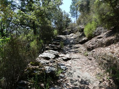
On this path, you see the determination of the inhabitants of the Cévennes to tame the rebellious environment: here, an arch bridge crosses a river whose water has carved a steep-sided valley, creating “cauldrons”; there, one whole side of the path has been dug out of the rock to cross from one slope to the other; further on, bancels (low walls) have been built to hold back the soil in which the chestnut trees were planted. Locals even rerouted the water to irrigate their crops and protect themselves from the run-off of powerful rains. This is a well organised environment: the water collected at the spring is stored in basins before being redistributed via a network of béals (irrigation channels). The vegetable plots are on terraces closest to the house. A little further away are the irrigated fields, fruit trees, mulberry trees and beehives. The chestnut orchard surrounds the crop land. On the terraces, gutters known as trincats allow water to run off. Stone thresholds have been built across the rivers to regulate the flow and to regulate any soil washed away by the water.
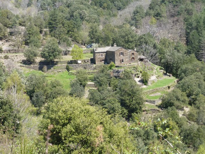
Les Ayres - nathalie.thomas HistoryLes Ayres
Through the ages, the location of Les Ayres on the draille (drovers’ road) brought merchants, mule drivers and shepherds and made the hamlet a well-known spot for loues (hiring fairs), where day labourers – shepherds, horsemen, threshers – came to find work.
"There were three loues, the first on the Sunday after 29 September, on Saint-Michael’s, the big fair a week later and the third the following week (....)"
Labourers hired themselves out for various jobs: silkworm or chestnut harvesting, threshing wheat or picking grapes, guarding and accompanying sheep flocks on the summer pastures… There was no work contract when employer and employee reached agreement. The day labourer left a personal belonging with his employee as a security.
Saint-André de Lancize - nathalie.thomas HistorySaint-André in the old days
"In Saint-André, we had sheep, goats, a horse and pigs, but the farm did not bring in enough money. In the summer I went up to Le Pont de Montvert to make hay, and in the autumn I worked on the grape harvest. Locals also went down the mountains to do the strawberry season, the asparagus season and the melon season. There was a man from St-Germain, who took his scythe and worked cutting grass, moving higher and higher into the mountains: to above Jalcreste and then all the way to Le Pont-de-Montvert. Here, the hay was ready for cutting in May, in Le Pont at the end of June".
Between Saint-André and Le Viala, you cross the Gourg de la Vache, so called ever since a cow fell in and drowned.
Description
Walk uphill alongside the road for 260 m.
1) Take the path on the right downhill to the river. Cross the bridge and go back up on a path with hairpin bends, which crosses a track three times.
2) After the chestnut orchard, take the track on the right to the road.
3) Cross the road and take the path which climbs above Le Valès to Les Ayres.
4) Turn left onto the D 54 to go through the village and, by the big chestnut trees, take the track on the left (the former draille or drovers’ road) to the Croix de Bourrel.
5) Shortly before the Croix de Bourrel, take the path on the left to join the road. Turn right onto the road. At the first intersection, turn right; at the second, turn left to walk through the hamlet of Saint-André de Lancize.
6) In the lower hamlet, take the grassy path through the gardens and meadows, then cross a ford, "le Gourg de la Vache". Continue on this path, cross a second ford, and walk uphill to join the road.
7) Turn left onto the road and, as you leave Le Viala, take on your right the small road that goes uphill to the hamlet of La Carrière. Go past the houses, stay on the track, join up again with the D 984 to reach Valmale. Go downhill on the road and take the track below the road, on the left, to return to your car.
- Departure : D 984 between Saint-André de Lancize and Saint-Germain de Calberte
- Arrival : D 984 between Saint-André de Lancize and Saint-Germain de Calberte
- Towns crossed : Saint-André-de-Lancize and Saint-Hilaire-de-Lavit
Forecast
Altimetric profile
Recommandations
NB. This walk is not recommended in wet weather (slippery rock and fords). Make sure your equipment is appropriate for the day’s weather conditions. Remember that the weather changes quickly in the mountains. Take enough water, wear sturdy shoes and put on a hat. Please close all gates and barriers behind you.
Information desks

Tourism'house and national Parc at Florac
Place de l'ancienne gare, N106, 48400 Florac-trois-rivières
This office is part of the National Park's associated tourist-information network, whose mission is to provide information on, and raise awareness of, the sites and events as well as the rules that must be observed in the National Park's central zone.
On site: exhibitions, video projections, events and shop Open year-round

Office de tourisme Des Cévennes au mont Lozère
le Quai, 48220 Le Pont de Montvert sud mont-Lozère

Tourism office Des Cévennes au mont-Lozère, Saint-Germain-de-Calberte
Village, 48370 Saint-Germain-de-Calberte
This office is part of the National Park's associated tourist-information network, whose mission is to provide information on, and raise awareness of, the sites and events as well as the rules that must be observed in the National Park's central zone.
Open year-round, except for 2 weeks at Christmas
Access and parking
From the Col de Jalcreste pass on the N 106, towards St-André de Lancize on the D 984, then towards St-Germain de Calberte. From when you leave Valmale, drive another 500 m lower down to a bend where you park and start (or else drive 3 km and park by the side of the road, above Saint-Germain de Calberte).
Parking :
Calculateur d'itinéraire Lio
Utilisez le calculateur liO pour organiser votre trajet en région Occitanie.
Autres régions
Calculez votre itinéraire en Auvergne Rhône Alpes sur Oùra
Biodiversité autour de l'itinéraire
Source


Report a problem or an error
If you have found an error on this page or if you have noticed any problems during your hike, please report them to us here: