
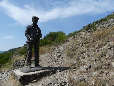
Sheep bridge
The ridge path that you are on is a former route for transhumant sheep (sheep going to and from summer pastures). As you explore the sheep bridge and walk back downhill, alongside you is a former forest now planted with downy oaks.
4 points of interest
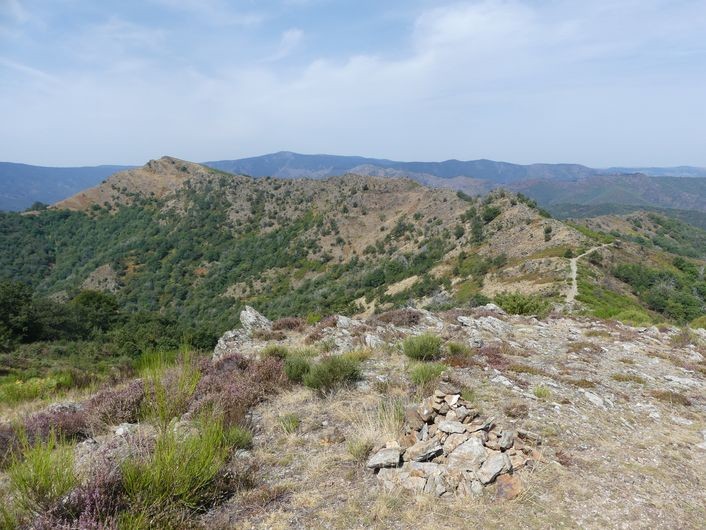
Le pastre - Nathalie Thomas AgricultureThe draille (drovers’ road) and the sheep bridge
The draille (drovers’ road) and the sheep bridge architecture The sheep bridge at the Col de l’Asclier is on an important draille (a traditional path for livestock migrating to the upland summer pastures of Mont Aigoual and Mont Lozère), which was also a King’s road during the Camisard revolt in the 18th century, a peddlers’ road and is now a long-distance hiking path. The Col de l’Asclier pass (from Occitan asclar, to split), where the road seems to go through a gap, is well-named: it lies on a fault line in the rock. But the most astonishing is the bridge, a bridge without road. It was built to help sheep flocks negotiate this difficult spot!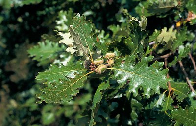
Chêne blanc ou pubescent - Yves Maccagno  Natural environment
The downy or pubescent oak
Before the pass, you can see a downy oak wood below the path, with some good-sized specimens. This tree is native to low and intermediate altitudes; from the 9th century onwards, sweet chestnuts were planted in its stead. And yet it provides high-quality wood, resists fire and drought due to its deep roots, and shelters a large number of insect and herbaceous plant species (700 different plant and animal species, including 490 of beetles that live in wood).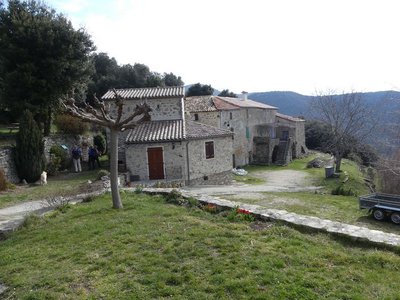
Le hameau du Puech sigal - Nathalie Thomas  History
Belvédère of Le Puech Sigal
From the Puech Sigal belvedere, you have amazing views over the upper Hérault valley. The fact that the name Sigal is close to séguéla, Occitan for rye, suggests that rye was grown here. There are believed to have been Benedictine months in the area. The cobblestoned path (calade) leading via the great drovers’ road to the Col de l’Homme Mort pass makes this hypothesis plausible...
La culture de l'Oignon - Nathalie Thomas HistoryPuech Sigal
At Puech Sigal (from the Occitan for “rye”), the land has been farmed since the Middle Ages. Some believe that there were local Benedictine monks at the time. Certainly, many areas were cleared and enhanced by monks during that period. This sunny belvedere gives superb views onto the Aigoual massif and the upper Hérault valley. Around the egde of this hamlet with its granite houses are vegetable gardens, meadows and orchards, giving the site the feel of an island amidst a sea of holm oaks and chestnut trees.
Description
Signposts will guide you all along this route, as well as yellow painted waymarks. In the description below, the signposted place names and/or directions are given in bold italics between quotation marks:
From your starting-point at "Puech Sigal", take the track on the left. Follow signs for
- "Favières",
- "Jasse de Rieusset",
- At “Col de l’Homme Mort”, Turn right toward
- "Le Clos",
- "Col de l'Asclier". Go downhill on the road for 100m
- At "Source de l'Asclier", take the path on the right and go downhill to “Mas Corbières”.
- At "Mas Corbières", head for "Puech Sigal" via
- "Valnières".
- Departure : Puech Sigal
- Arrival : Puech Sigal
- Towns crossed : Val-d'Aigoual and Les Plantiers
Forecast
Altimetric profile
Recommandations
Before committing yourself to a circuit, ensure that it is suitable for your activity level and ability. Remember that the weather changes quickly in the mountains. Take enough water. Please close all gates and barriers behind you.
Caution: The downhill section to Mas Corbières is difficult.
Information desks

Tourism & national parc'house
Col de la Serreyrède, 30570 Val d'Aigoual
The Maison de l'Aigoual houses the tourism office Mont Aigoual Causses Cévennes and the Maison du Parc national. This visitor centre provides information on and raises awareness of the Cévennes National Park, its sites and events as well as the rules that must be observed in the National Park's central zone.
On site: changing exhibitions, video projections, Festival Nature events and shop Open year-round

Tourism office Mont Aigoual Causses Cévennes, Valleraugue
7 quartier des Horts, 30570 Valleraugue
This office is part of the National Park's associated tourist-information network, whose mission is to provide information on, and raise awareness of, the sites and events as well as the rules that must be observed in the National Park's central zone. : Open year-round
Transport
liO is the regional public transport service of the Occitanie/ Pyrénées – Méditerranée region. It facilitates everyone’s movements by prioritising public transport. For more information, call 08 10 33 42 73 or go to www.laregion.fr
Access and parking
From the D986, drive uphill to Notre-Dame de la Rouvière. As you enter the village, turn left onto the D152A to Puech Sigal.
Parking :
Calculateur d'itinéraire Lio
Utilisez le calculateur liO pour organiser votre trajet en région Occitanie.
Autres régions
Calculez votre itinéraire en Auvergne Rhône Alpes sur Oùra
Biodiversité autour de l'itinéraire
Source


Report a problem or an error
If you have found an error on this page or if you have noticed any problems during your hike, please report them to us here: