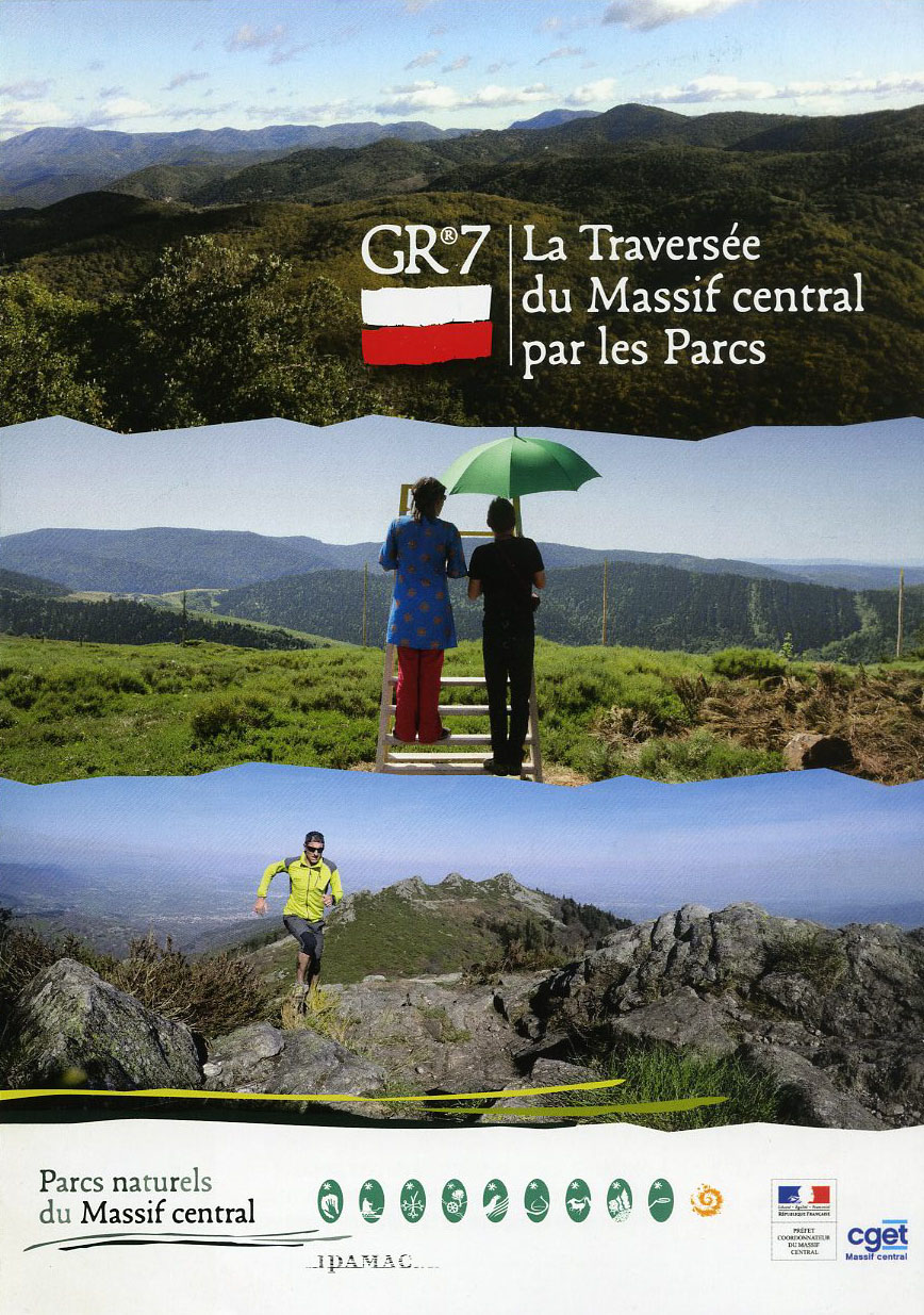
GR®7
This long-distance trail takes you on a journey from the Vosges to the Pyrenees. It roughly follows the watershed: on one side are the waterways that converge towards the Mediterranean; on the other, those that flow into the English Channel and Atlantic. The route crosses highly characteristic sites. Starting at the Ballons d’Alsace passes, it traverses the Regional Nature Reserve of the Ballons des Vosges. It then briefly veers into the Haute-Marne department before crisscrossing Burgundy, leading from Dijon to the uplands of the Auvergne-Rhône-Alpes and Occitanie regions. Passing through three Regional Nature Reserves (Pilat, Monts d’Ardèche, Haut-Languedoc) and the Cévennes National Park, it ends in Andorra via the Pyrénées Catalanes Regional Nature Reserve and Cathar country.
31 points of interest
La croix des missions - Nathalie Thomas  History
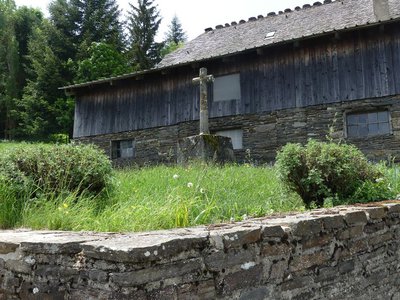
The “mission” cross
In the municipality of Le Bleymard, there is a large number of crosses and other small religious heritage elements, which bear witness to inhabitants’ fervour in the old days. You will see them as you enter villages, on main squares and at crossroads, to protect the walker and ploughman. Offerings sometimes took the form of crosses, which were then called “mission” crosses.
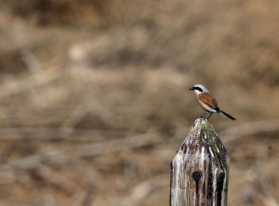
Pie-grièche écorcheur - Régis Descamps  Fauna
FaunaPasserine birds
Open spaces with a few trees and bushes favour passerine birds. Passerines are the largest and most varied order of birds, containing over half of all bird species. The red-backed shrike in particular likes this environment, which abounds in the large insects that constitute its main food source. The shrike is strictly migratory and hibernates in eastern Africa.
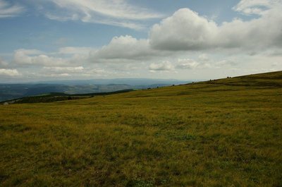
Paysage - © Brigitte Mathieu  Flora
FloraSubalpine short-grass prairie
Marker 1
Like garden or sports pitches, short-grass prairies are shaped by mankind. Grazing and controlled burns are the tools for their maintenance here. The main plants are nard and fescue, perennial grasses related to wheat. If you cut (graze) one of their stalks, five more will soon form; if you trample them, they multiply and become very dense. This kind of “torture” creates a thick plant cover that stabilises the sparse dark soil, which is derived from erosion of the ever-present granite. Here, then, are some clues for the appropriate management of this environment, which becomes weakened if neglected.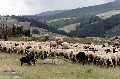
Transhumance sur la draille de l'Aubaret - © Olivier Prohin  Pastoralism
The draille du Languedoc
This draille (path for seaonal livestock migration) was frequented by flocks of sheep during the transhumance and by farmers going to buy or sell animals at Bellecoste Fair, which was held every 16 July and 25 September. The path linked the inhabitants of the plateau to the village of Saint-Maurice-de-Ventalon. (Julie Hugon)
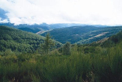
Boisement du Bougès sud - © Guy Grégoire FloraThe Bougès state forest
This covers an area of about 3,300 hectares. Reforestation was carried out between 1880 and 1925, at the beginning of the agricultural decline, to fight the erosion caused by over-grazing. Today, the Office National des Forêts manages this forest, primarily with the goal of protecting the different forest species and ecosystems, but also with a view to making it productive. The forest is made up of a number of tree species, including spruce, silver fir, larch and Corsican pine. A varied fauna inhabits the forest (deer, wild boar, birds of prey). A few capercaillies, re-introduced by the Cévennes National Park, live in these wide open spaces. (Julie Hugon)
La Draille du Languedoc - otcevennesmontlozere PastoralismThe Languedoc draille
This draille (path for seasonal livestock migration) is known as the Languedoc draille and has seen tens of thousands of sheep pass by that have come up the many drailles from the Midi, combining into ever larger flocks before reaching the summer pastures on the Mont Lozère plateau. The plant cover, grazed and trampled by so many sheep, had no time to grow back. A few flocks and a few shepherds still keep the tradition alive. Other flocks are brought to the summer pastures by lorry.

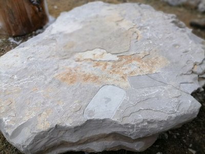
 Geology
Sandstone outcrop
Marker 13
On the other side of the road, the sandstone bank shows criss-crossing layers which were deposited by flood waters with very strong currents. The pebbles they contain have angles that are barely blunted, indicating that they were not carried far. This very crumbly sandstone is generally held together by a greenish clay rich in white mica without any limestone. It bears witness to the arrival of the sea, 200 million years ago. On this rock face, plants have to compensate for intense erosion by being able to develop rapidly and withstand a certain amount of dryness. There are a very few chamomile plants and streamlined plantains.- History
Place de la Madeleine
Marker 5
The fountain dates from the 18th century. At the end of the 19th century, the bust of Marianne – the personification of the French Republic – was added. At the same time, a poplar was planted by republican youth as a symbol of freedom. From here, you can see several bourgeois houses, which mostly date from the 17th and 18th centuries. They bear witness to the village’s thriving past, when it had some 20 voituriers (merchant-carters), who would drive their carts down to the plains laden with wool and chestnuts and return with salt, wine and oil. Under the houses' large porches, harnesses and carts were kept. During fairs, the seed market took place in these vaults and those of the town hall. - History
The Château
Marker 6
Constructed in the 12th and 13th centuries, the Château was entirely rebuilt in the early 16th century. From 1710 to 1715, it was modified by the Lord of Barre, who had his coat of arms carved above the entrance. Two towers were also added at this time. During the 1789 Revolution, the coat of arms disappeared under vigorous hammer strokes. In the early 19th century, during an expansion, the main tower was removed. - History
Place de la loue (Hiring Square)
Marker 1
This little square, located at the north-eastern entrance to the village, was where the “loue” (hiring) used to be held during the great spring and autumn fairs: shepherds, domestics and chestnut gatherers would sit on the parapet and hope for an employer to take them on. The village hosted 12 to 15 fairs every year. The spring and autumn ones could attract up to ten thousand people from neighbouring departments, but also from the Var, Vaucluse and Bouches-du-Rhône. This village-rue (one-road village) was protected at each end by a fortified gate. One of them, called the Florac Gate, stood near the Place de la Loue. It was destroyed in the early 19th century. 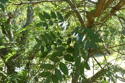
Frêne commun - Nathalie Thomas FloraAsh trees
Ash trees, like the ones that border the path, like cool and damp environments. They were planted alongside paths by locals because ash branches, cut towards the end of summer, provided additional fodder for livestock.
Météosite de l'Aigoual - © Olivier Prohin  Water
WaterMont Aigoual
A beautiful view onto Mont Aigoual (1,567 m) – a mountain of winds, fog, snow and rain. Banks of clouds coming from the Mediterranean rub against its slopes and can cause violent precipitation (also called Cévenol episodes). This temperamental mountain is home to the last mountain weather-station in France.
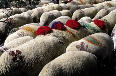
Transhumance - © Michelle Sabatier AgricultureThe Margeride draille (drovers’ road)
The draille follows the ridge and crosses the Can de l'Hospitalet plateau. This transhumant trail enables the sheep flocks of the plains (of the southern Cévennes and the Crau) to move up to northern Gévaudan (Aubrac, Margeride, Mont Lozère). This draille is only one branch of a larger network along which transhumant livestock still travel.
La Vallée de Sexte et son manteau blanc - Béatrice Galzin WaterCol Salidès
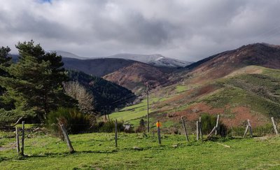
The bare ridge that rises opposite is the watershed between the Mediterranean and the Atlantic. Rain that falls on the Sexte valley flows into the Tarnon below (on the left) and ends up in the ocean. On your right, the Mediterranean side offers extraordinary views onto the foothills of the can de l’Hospitalet plateau and the entirety of the Cévenol mountains. On some days, the Alps and Mont Ventoux can be seen in the distance …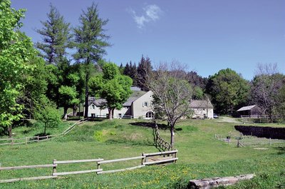
Aire de Côte - Stephan.Corporan HistoryAire de Côte
Aire-de-Côte farm was purchased by the French State in 1862, during the period of reforestation. Before the farm became a stopover gîte, it was for a long time the residence of the local forester and his family. In the first half of the 20th century, Aire-de-Côte was very different. To the north, behind the house, was the draille (drovers’ road), lined by upright stones and 40 to 50 metres wide. Thousands of transhumant animals passed every year on their way to or from summer pastures. The transhumant animals stopped there at lunchtime, then continued on towards Mont Aigoual.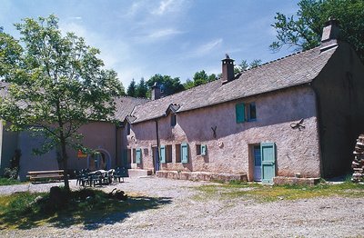
Guy.Grégoire HistoryA Resistance refuge
In early 1943, the first Resistance group of the Cévennes was formed. The refuge of the Aire-de-côte group was one of the wooden shacks used for forestry works, whose roof was camouflaged using branches. On 10 July 1943, a message warned the post office in Rousses that a German attack was imminent. The Resistance was informed – but a storm delayed the group’s departure. The Germans arrived… The forester was arrested as an accomplice, accused of being in radio contact with London. Indeed, the Aire-de-côte Resistance listened to a crystal radio set built by the two Jews who were hiding there.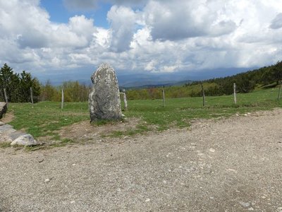
Vue depuis Font de Trépaloup - nathalie.thomas FloraThe evolution of plant life
At the pass stands a schist menhir (standing stone). To the north, in Trépaloup ravine, hewn flint implements bear witness to a human presence in the region since prehistoric times. Palynological analyses (studies of pollen fossilised in peatbogs) have allowed scientists to piece together the plant life on Mont Aigoual from 8,000 to 5,000 BC. Pine predominated, accompanied by birch and hazelnut. Then pine populations gradually diminished. The damp climate warmed up, favouring the spread of oak and hazelnut. Finally, the increased damp and cloud cover at altitude allowed fir and beech to develop. From the end of the first century BC, the substantial percentage of grasses shows that forest had receded in favour of pasture and prairies. This was the start of the great deforestation.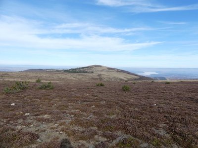
Le Portalet - nathalie.thomas FloraShort-grass prairies and heath on the summit of Mont Aigoual
Here, only species with a short reproductive cycle can settle due to the frequently glacial climate. The heath has been invaded by heather and mountain pine. This zone is barely wooded due to the violent winds and is comparable to subalpine vegetation, consisting of short-grass prairies and heather and blueberry moor. It is sometimes called pseudo-alpine.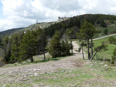
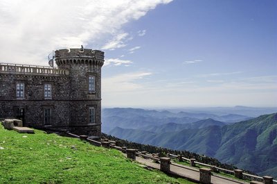
Observatoire de l'Aigoual - nathalie.thomas HistoryThe meteorological observatory
Inaugurated in 1824, the meteorological observatory was built on the initiative of Georges Fabre, one of the pioneers of the reforestation of Mont Aigoual. His work with the botanist Charles Flahault enabled the creation of the arboretum of L’Hort de Dieu. The first meteorological data were gathered by agents from the French National Water and Forestry Commission. Since 1943, the observatory has been managed by the National Meteorological Office. It is France’s last mountain weather station that is inhabited year-round.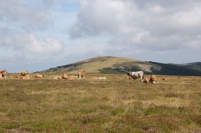
Troupeau au sommet de l'Aigoual - © Nathalie Thomas FloraSummit of Mont Aigoual
At an altitude of 1,565 m, the climate is harsh: weather conditions are the same as they would be at 2,000 m elsewhere, with only four “frost-free” months a year. Winds of above 60 kph blow on 265 days a year, and the average annual temperature is 4.8°C. Trees do not have enough time to complete their life cycle. Local plant formations are those of the montane zone: subalpine short-grass prairies.
Archéosmart (Marc Limousin) - © Filature du Mazel  Archaeology
Archeosmart (Marc Limousin)
Smartphone imprints appear on the rocks: fossils of the present that will become mysterious in the future. This carved stone, like the cup-shaped marks and other rock art of the region, discloses history revealed in matter and resonates with Malraux’s phrase: “The future is a present given to us by the past”.
le Pole Nature de l'Aigoual - Béatrice Galzin  Natural environment
Pôle Nature 4 Saisons
The Pôle Nature 4 Saisons of the Aigoual massif offers outdoor activities in all seasons in the central zone of the Cévennes National Park, overlooked by the legendary summit of Mont Aigoual (1,570 m). Discover our network of trails on foot, on horseback, by bike, or else by mountain-bike or with a donkey, as the fancy takes you!
Children can explore the orienteering circuit or geocaching.
For the sportier among you we have laid out trail running circuits!
Prefer road biking? We have created circuits of varying difficulty levels so you can discover our villages and valleys.
Try not to make any noise! Wildlife enthusiasts can spot mouflons and other animals.
And if you would just like a gentle walk on the massif, the discovery trail “The cliffs of Mont Aigoual” is for you. There are various rest stops over its 4.5 km, with only 150 m in height difference.
We look forward to seeing you on our paths.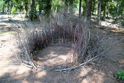
Nids (Céline Pialot) - © E. Fréget FaunaThe Nests (Céline Pialot)
Little by little, the bird makes its nest, its cosy nest, baby cocoon, wasps’ nest…
Like a bird, the artist has gathered materials offered by nature and has arranged them to build three nests, three refuges, three circles that reference perfection and invite meditation.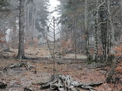
Arbre feuille (Alain Bernegger) - © Filature du Mazel FloraLeaf-Tree (Alain Bernegger)
Leaf-Trees use a veined structure to create a visual resonance between the tree and the leaf. The change of scale works like an inverted echo of this fractal structure. And as winter comes, the eternal summer of the Leaf-Trees confronts the winter of the bare branches.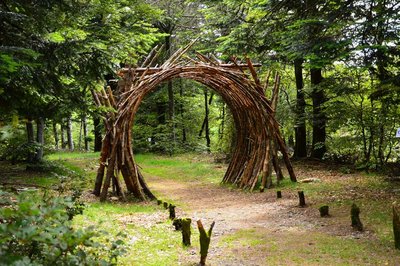
L'Orée (Yoann Crépin) - © Filature du Mazel  Know-how
On the Verge (Yoann Crépin)
A doorway to a circuit of art within the natural environment.
To fuse and interact with the environment and play with the seasons, time, light and weightlessness. To let humanity express itself through nature and nature express itself through humanity – a necessary interaction, a symbiotic interaction that inspires us to discover another world.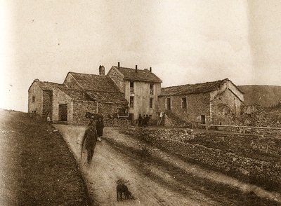
Maison forestière de la Serreyrède - © Jacques de Joly AgricultureLa Serreyrède
Before 1861, the house at the Col de la Serreyrède was inhabited by two families of farmers. They owned some livestock and had a vegetable garden, whose terraces you can still see above the La Caumette track. From 1861 on, the farm was inhabited by a forest ranger. It was only bought by the state body Eaux et Forêts in 1883, to be turned into a forester's house. It became one of Georges Fabre's headquarters during the reforestation of the Aigoual massif. The Cévennes National Park, tourism office and Terres d'Aigoual growers have now joined forces to revive La Serreyrède with the help of the Communauté de Communes Causses Aigoual Cévennes – Terres solidaires.
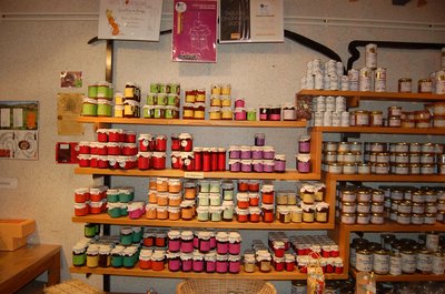
Boutique des producteurs - © Nathalie Thomas AgricultureThe association "Terres d'Aigoual"
The Cévennes National Park rents out part of the building to the association, enabling local farmers to sell their products directly to the public. The association brings together farmers who wish to promote what they produce and share their know-how. They also enjoy sharing their vision of farming- high quality produce and products,
- human-sized farms,
- mutual aid.
Come and discover their products!
- History
From beech copse to mature plantation
Marker 1
Around 1850, before reforestation began, the inhabitants of the Cevennes were using local wood resources on a massive scale for heating and in industry, especially spinning-mills. Gradually, only a few beech copses remained, which were cut every 25 to 40 years. Grazing by tens of thousands of sheep further reduced the herbaceous plant cover. Much weakened, the plant cover was then also subjected to heavy precipitation, the so-called Cevenol episodes. It is against this backdrop that the lengthy work of the foresters began. To reduce risks and establish a lasting forest cover, the first technique was to make use of what was already present by converting the disused copses into mature plantations. - Know-how
Productive forest
Marker 2
Another method of creating a durable forest cover is to plant or sow. This work is carried out either on bare soil or among existing tree stands. The Aigoual reforestation programme was a gigantic effort, requiring 900,000 days of work, the planting of 60 million conifers and 7 million deciduous trees, and sowing of 38 tonnes of seeds. Spruces and pines, which can be planted in full sunlight and grow quite quickly, were widely used. Under the forest canopy, preference was given to firs. - Natural environment
Irregular forest
This tree population consists of trees of very different diameters, ages and heights. Species are mixed: mainly pine, but also beech, rowan and whitebeam. This is an irregular mature forest, a forestry dynamic that is interesting for several reasons: it creates permanent forest cover; resistance to soil erosion; better resilience against storms or parasite attacks; regular production, etc. In the small clearing to the left of the path, the sunlight now penetrating to the forest floor has made natural regeneration of beech and fir possible, ensuring the renewal of the forest.
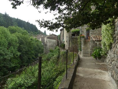
Le village d'Aulas - Nathalie Thomas HistoryThe village of Aulas
In the old days, the Place de l’Airette was where the wheat was thrashed. The village’s two fountains – on the Place de l'Airette and on the church square – were created on the initiative of the village council in 1887. They were almost removed when the houses were connected to mains water but were preserved by the support of certain councillors. Aulas was called Aulacio in 1001, from the Latin man’s name Aulas. In the 14th century, the village was fortified due to the many groups of brigands in the area. The ramparts were bordered by ditches and had gates. One of them, La Poterne, can still be seen. The village has remained picturesque thanks to its narrow lanes, its covered passage and its old buildings.
Description
Only the section of this GR® [long-distance hiking path] which crosses the territory of the Cévennes National Park, between Bastide-Puylaurent and Le Vigan, is described here. It takes a week to hike.
All information on the whole route can be found on the site monGR.fr of the French hikers’ federation, the Fédération française de la randonnée pédestre.
- Departure : La Bastide-Puylaurent
- Arrival : Le Vigan
- Towns crossed : La Bastide-Puylaurent, Luc, Mont Lozère et Goulet, Cheylard-l'Évêque, Saint-Frézal-d'Albuges, Cubières, Pont de Montvert - Sud Mont Lozère, Vialas, Saint-Privat-de-Vallongue, Saint-André-de-Lancize, Saint-Germain-de-Calberte, Cassagnas, Saint-Martin-de-Lansuscle, Barre-des-Cévennes, Molezon, Cans et Cévennes, Vebron, Le Pompidou, Rousses, Bassurels, Saint-André-de-Valborgne, Val-d'Aigoual, Meyrueis, Saint-Sauveur-Camprieu, Dourbies, Bréau-Mars, Arphy, Aulas, Le Vigan, and Avèze
Forecast
Altimetric profile
Recommandations
NB: For various reasons, the waymarked path may differ from that shown in the topographic guidebook: please follow the waymarks on the trail. Make sure your equipment is appropriate for several days of hiking as well as the day’s weather conditions. Remember that the weather changes quickly in the mountains. Take enough water, wear sturdy shoes and put on a hat. Please close all gates and barriers behind you.
Information desks

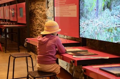
Tourism'house and national Parc at Florac
Place de l'ancienne gare, N106, 48400 Florac-trois-rivières
This office is part of the National Park's associated tourist-information network, whose mission is to provide information on, and raise awareness of, the sites and events as well as the rules that must be observed in the National Park's central zone.
On site: exhibitions, video projections, events and shop Open year-round
Transport
Ligne de Bus TER entre Mende et La Bastide-Puylaurent.
Ligne de train TER entre Alès et La Bastide-Puylaurent.
Ligne de Bus Le Vigan-Alès.
https://www.lio.laregion.fr
Access and parking
Parking :
Calculateur d'itinéraire Lio
Utilisez le calculateur liO pour organiser votre trajet en région Occitanie.
Autres régions
Calculez votre itinéraire en Auvergne Rhône Alpes sur Oùra
Biodiversité autour de l'itinéraire
Source


Report a problem or an error
If you have found an error on this page or if you have noticed any problems during your hike, please report them to us here: