
Mas Saint-Chély, MTB circuit #5 (graded blue)
This bare landscape, shaped by generations of farmers and sheep-breeders, is closely linked to human history.
5 points of interest
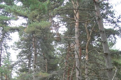
Le pin sylvestre - OT Gorges du Tarn Causses & Cévennes nc  Natural environment
The Scots pine
The Scots pine is the main natural tree variety of the Grands Causses plateaux, as it is well-adapted to poor soils. You can recognise it by it its bark, which is a reddish brown to salmon-ochre colour on the upper part of the trunk; its needles are short and paired. Being hardy, it does not fear climate change. As a pioneer species, it settles on abandoned land.
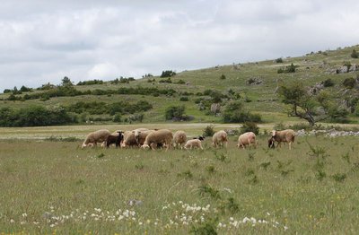
Brebis sur le causse Méjean - Nathalie Thomas AgricultureThe Causse sheep
The Blanche du Massif Central (BMC) is a sheep variety that originated on the Margeride plateau. Its hardiness means that it is well-adapted the mountain climate. Its quality meat and its capacity to produce lambs at all times of the year are appreciated by the meat industry and have made it increasingly popular.
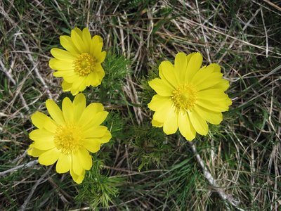
Adonis vernalis - © Bruno Descaves  Flora
FloraAdonis vernalis (spring pheasant's eye)
Whilst this member of the buttercup family might seem plentiful, it has become rare and is limited to a few places in France (Causses, Alsace) and south-eastern Europe. It can be seen in April-May in the steppe flora. This plant is protected – you may take photos but under no circumstances take the plant! It secretes a substance through its roots that tends to limit the growth of plants around it, especially legumes.
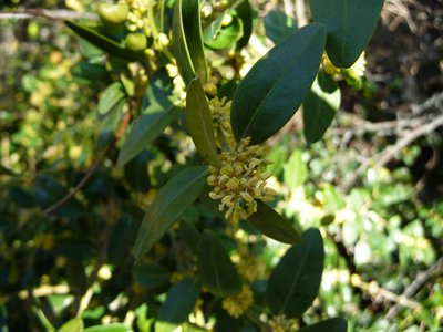
Fleur de buis - Nathalie Thomas Natural environmentBoxwood
The scientific name of boxwood, Buxus semperviens, means “always green”. It is the best-known shrub on the Causses but also the most invasive. Its small shiny leaves limit water loss in the heat. Box is low-maintenance and tolerates poor and dry soils as well as wide temperature variations. It invades pastures; sheep do not like its leaves at all. It is hard to get rid of, and only the regular trampling of the flocks stops its progress. In the old days, it was sometimes used as manure on fields.
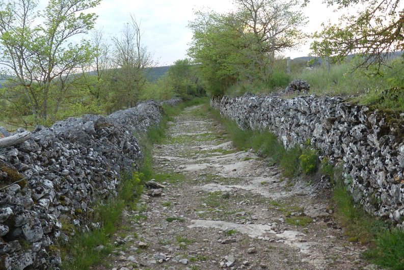
Doline - © OTGCC nc  History
Woods and deforestation
Afforestation and deforestation seem to be the fate of the Causse landscape. In the Neolithic, the first farmer-shepherds settled on the fertile areas of the plateaux, which were covered by beech and oak forest at the time. This lead to the forest being cleared for sheep pasture and for farmland. With demographic expansion, deforestation accelerated and the cultivated areas expanded. Subsequently, the local potteries, lime kilns and, later, mines brought about a new wave of deforestation to satisfy their need for wood.
Description
From the car park by the church, take the road that goes downhill to the war memorial. Continue straight ahead between the houses. Continue on a track suitable for motor vehicles that turns into a path and climbs to a wide track.
- Take the track on the left (detour: you can reach Saint-Cosmas’ Chapel by taking the track on the right for 700m). Stay on the main track.
- Go right then left on the tarred road towards Toulousette. Leave it behind to take a track near a container shelter, then continue to Mas de Val.
- Cross the hamlet. Continue on a path bordered by low walls until you reach the D 16.
- Cross the road and take the track opposite. Go through two gates (close them properly). At the second gate, take the track on the left to the D 16.
- Continue straight ahead. Climb up a slope and go back down towards a road (NB: technical section).
- Continue opposite towards Prunet until you reach a small pass.
- Go through the fence to take the track on the left. Follow the main path, through a second fence. When you see the village, go left then right to reach the road. By the houses, turn right twice to return to the starting-point.
- Departure : Mas Saint-Chély
- Arrival : Mas Saint-Chély
- Towns crossed : Mas-Saint-Chély
Forecast
Altimetric profile
Recommandations
No off-roading. You are strongly encouraged to wear a helmet. Do not forget your repair kit and a small tool kit. Close barriers and gates behind you. Slow down in farms and hamlets.
Information desks

Tourism office Cévennes Gorges du Tarn, Sainte-Enimie
village, 48210 Sainte-Enimie
This office is part of the National Park's associated tourist-information network, whose mission is to provide information on, and raise awareness of, the sites and events as well as the rules that must be observed in the National Park's central zone.

Tourism'house and national Parc at Florac
Place de l'ancienne gare, N106, 48400 Florac-trois-rivières
This office is part of the National Park's associated tourist-information network, whose mission is to provide information on, and raise awareness of, the sites and events as well as the rules that must be observed in the National Park's central zone.
On site: exhibitions, video projections, events and shop Open year-round
Access and parking
From Ste-Enimie or Meyrueis, take the D 986. At the Col de Coperlac pass, head to Mas St-Chély.
Parking :
Calculateur d'itinéraire Lio
Utilisez le calculateur liO pour organiser votre trajet en région Occitanie.
Autres régions
Calculez votre itinéraire en Auvergne Rhône Alpes sur Oùra
Biodiversité autour de l'itinéraire
Source


Report a problem or an error
If you have found an error on this page or if you have noticed any problems during your hike, please report them to us here: