
4. On Fageas ridge (day 4)
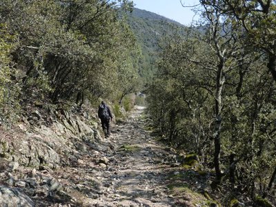
From Briontet onwards you lose altitude, and Mediterranean vegetation gradually takes over, with holm oaks. Imagine the time it took to build this paved road that leads you into the heart of the village of Saint-Jean du Gard ! Who placed the first stone ?
4 points of interest
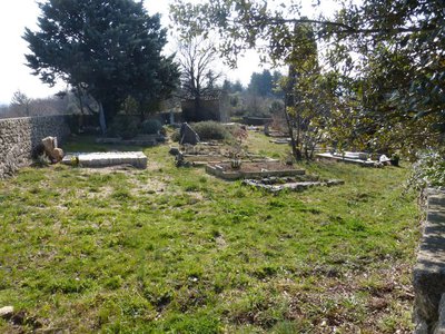
Cimetière communal - © Nathalie Thomas  History
Cemetery history
The walk leads you past the village cemetery, which was in fact the Protestant cemetery. Soudorgues also has a Catholic cemetery, another particularity brought about by the turbulent history of the Reformation. Catholic cemeteries did not accept “non-Christians” or “heretic Christians”. There were countless exhumations of Protestant bodies in the 16th century. To put an end to this injustice, the Edict of Nantes ordered that “convenient” cemeteries be built for those who followed the so-called reformed religion. When the Edict was revoked, the order was also dropped. Huguenots had to renounce their religion to be buried in 'family” cemeteries in the countryside. Today, only the owners of these on-site cemeteries still have the right to be buried in them.

 Know-how
Lime kiln
The process of burning limestone to make lime has been used since the Bronze Age. The lime was mixed with sand to make mortar for building houses. Concrete was not known until the early 19th century. Lime is also a powerful antiseptic and was used to disinfect buildings, especially sheepfolds. The kiln operator had to maintain the kiln temperature at 800 to 1,000°C. Plaster was made from gypsum deposits using the same principle.
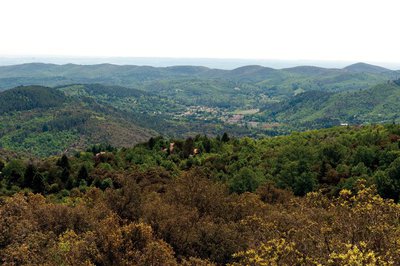
Vue des crêtes de Mauripe - © Olivier Prohin  Landscape
360° views from Mauripe
From here, on a clear day, you can see the Alps (west) and the Mediterranean (south). Looking northwest, you can make out Mont Aigoual, the Col de l'Asclier pass, the Col de Fageas with its television mast and, if you follow the ridges eastwards with your eyes, the Rocher de l'Aigle, Piécamp and La Mortière. The lowest ridge is the famous Corniche des Cevennes. Behind it, further east, are the mountain ranges of La Vieille Morte and Le Mortissou, and, in the far distance, the ridges of Mont Lozère. Far to the south, you can make out the city of Alès and, even further away, Mont Ventoux. In front are the town of Lassalle and then La Fage mountain above Saint-Hippolyte-du-Fort. On the horizon, the Mediterranean shimmers furtively.
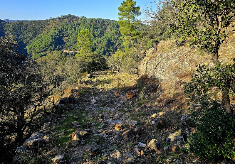
Descente au col de Mercou - © Nathalie Thomas AgricultureDraille
The rocky path becomes wider and has stone reinforcements on the downhill side, which shows that it was once used by large herds. This draille led from Saint-Jean-du-Gard to the summer pastures on Mont Aigoual. At the Col de Mercou pass (570 m), there are panoramic views northwards over the Corniche des Cevennes. The pass was once a site for trade and commerce, with its own market. Its name is derived from Mercury, the god of travellers and commerce. There are also references to Melkart, a Phoenician deity: Semitic traders left traces of their passage here in the architecture of the old proto-historic bridges. Melkart or Melqart was the tutelary god of the city of Tyre - whose name means “strong king” in Phoenician – and was the god of riches, industry and navigation. He was worshipped in the tenth century BC.
Description
Starting at “Soudorgues”, walk to “mairie de Sourdorgues” and then to “Les quatre chemins”.
- Continue to “sous Mauripe”, “Serre des Hubacs” and “Col du Mercou”.
- At “Col du Mercou”, walk to “Col de Briontet” (GR®61).
- Continue to “St-Jean du Gard” on the GR®61 via “La Rouvière”, “Jasse d’Alméras”, “La Malaygue”, “La Graussille”.
- Departure : Soudorgues
- Arrival : Saint-Jean du Gard
- Towns crossed : Soudorgues, Peyrolles, and Saint-Jean-du-Gard
Forecast
Altimetric profile
Recommandations
Make sure your equipment is appropriate for the day’s weather conditions. Remember that the weather changes quickly in the mountains. Take enough water, wear sturdy shoes and put on a hat. Please close any gates and barriers behind you.
Information desks

Tourism & national parc'house
Col de la Serreyrède, 30570 Val d'Aigoual
The Maison de l'Aigoual houses the tourism office Mont Aigoual Causses Cévennes and the Maison du Parc national. This visitor centre provides information on and raises awareness of the Cévennes National Park, its sites and events as well as the rules that must be observed in the National Park's central zone.
On site: changing exhibitions, video projections, Festival Nature events and shop Open year-round

Tourism office Cévennes Tourisme, Saint-Jean-du-Gard
Maison rouge, 30270 Saint-Jean-du-Gard
This office is part of the National Park's associated tourist-information network, whose mission is to provide information on, and raise awareness of, the sites and events as well as the rules that must be observed in the National Park's central zone.
Open year-round

Tourism office Mont Aigoual Causses Cévennes, Lassale
Centre Viala, rue de la Place, 30460 Lasalle
This office is part of the National Park's associated tourist-information network, whose mission is to provide information on, and raise awareness of, the sites and events as well as the rules that must be observed in the National Park's central zone. : Open year-round

Tourism office Mont Aigoual Causses Cévennes, Saint-André-de-Valborgne
les quais, 30940 Saint-André-de-Valborgne
This office is part of the National Park's associated tourist-information network, whose mission is to provide information on, and raise awareness of, the sites and events as well as the rules that must be observed in the National Park's central zone.

Tourism office Mont Aigoual Causses Cévennes, Valleraugue
7 quartier des Horts, 30570 Valleraugue
This office is part of the National Park's associated tourist-information network, whose mission is to provide information on, and raise awareness of, the sites and events as well as the rules that must be observed in the National Park's central zone. : Open year-round
Calculateur d'itinéraire Lio
Utilisez le calculateur liO pour organiser votre trajet en région Occitanie.
Autres régions
Calculez votre itinéraire en Auvergne Rhône Alpes sur Oùra
Biodiversité autour de l'itinéraire
Report a problem or an error
If you have found an error on this page or if you have noticed any problems during your hike, please report them to us here: