
Mas Cévenol de la Roquette
This walk allows you to explore a little valley off the beaten track, which evokes the special atmosphere of the Upper Cévennes valleys located on the Mediterranean side of the watershed. In the shade of holm oak and sweet chestnut, this path goes uphill from a mill to a complex of dwellings midway up the slope, in the cool air of a gully. The walk enables you to understand how the Cévenols managed and increased the value of their environment. From the art of construction to hydraulic arrangements, all the components of the traditional organisation of space are evoked on a preserved site.
20 points of interest

Anciens du Parc : Michel Monod, Paul Flayol, Jean Donnedieu de Vabres (premier président du PnC) - © Musée des Vallées Cévenoles  History
Dr Michel Monod (1934-1992)
This path is dedicated to Dr Michel Monod (1934-1992) who profoundly shaped the Vallée Française. A devoted mountain doctor and true Protestant, he was guided by rigorous ethics in all his professional, social and political commitments. As councillor of the Barre-des-Cévennes canton, mayor of Sainte-Croix, and president of the board of directors of the Cévennes National Park from 1982-86, he carried out his duties with the desire to open up the Cévennes to modernity without changing the area’s fundamental values of authenticity, discretion, liberty, hospitality and respect for others – values that are still the pride of the Cévennes today.

 Water
WaterLa Devèze mill
Marker 2
The bésal took the river water into the mill pond, called gourgue (gorga in Occitan). Natural basins in riverbeds are called gour (gorg). Releasing the water on demand made the millwheel go round, which in turn activated the turning millstones. This mill had several millstones to produce rye flour, walnut oil, hulled barley and chestnut flour.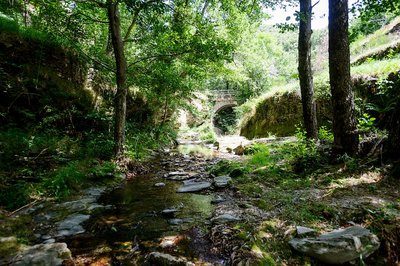
© Arnaud Bouissou TERRA WaterTrabassac stream
Marker 1
The Trabassac, which has cut deeply into the schist, has a low average rate of flow. But during storms it can abruptly go from being almost totally dry to a raging torrent. Then its capacity to erode is impressive! A water intake point built next to a small dam used to let water into a béal (or bésal in Occitan: irrigation channel), whose starting-point can still be distinguished. It directed the water to a mill (Point 2) built away from the banks so as to protect it from floods. The Mediterranean or southern barbel is a fish typically found in this stream, as is the brown trout.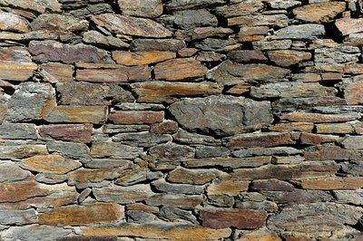
© Arnaud Bouissou TERRA  Geology
Types of schist
Marker 3
Despite their varied appearance, all types of schist have one thing in common: they separate into parallel slabs. In the Cévennes, where schist is the predominant rock, it mainly occurs in the form of mica schist. Schist is a former sedimentary rock, which has been dragged into the depths of the Earth’s crust under very high pressures and temperatures, and folded several times. A considerable uplift of the far south-eastern part of the Massif Central about 1.8m years ago meant that the Cévenol valleys were created by erosion more “recently”. This has given the Cévennes their current appearance. On this acid substrate, holm oaks manage on thin layers of soil.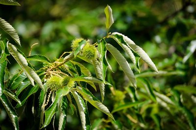
Chataigneraie - © Arnaud Bouissou TERRA AgricultureThe sweet-chestnut orchard
Marker 4
The sweet-chestnut tree is a native species, but its cultivation really began in the Middle Ages, with a very significant expansion in the 16th century, until it declined as an economic resource in the 19th century. The chestnut tree was the pivotal tree of a civilisation, because of the high quality of its wood, which is very resistant; because of the fact that it bears fruit fairly regularly, feeding both humans and animals; and through the use of its foliage and tannin. It is therefore not surprising to see old chestnut orchards near mas (farmhouses). Grafted chestnut trees (identifiable by the bulge on the trunk) produce nuts. The rest, called bouscas, are not intended to be productive.- Water
Bancels and springs
Marker 5
The terraces (bancels) on this steep slope are narrow and supported by tall schist walls, which make them look like a staircase. The surfaces that they border have a slight incline across the slope, enabling rainwater to drain away towards the gully, which then carries them to the stream. This is a good example of the dual purpose of bancels: they are also effective at retaining soil, thus creating cultivatable areas. The seepage creates a spring above the steps into the garden. This is Mas Chaptal’s only year-round water supply. A vegetable garden has been laid out below it to take advantage of the irrigation. 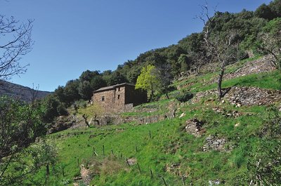
La Roquette, Molezon - © Bruno Daversin  Architecture
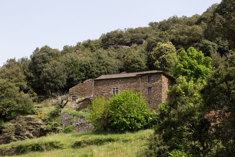
Mas Chaptal
Marker 6
Mas Chaptal is the most handsome of the three groups of buildings in upper La Roquette. Its large south-facing facade, built of schist blocks of equal size, has regular openings. A beautiful mullion window livens up the austere schist wall. The door and window surrounds have all been made very carefully, often from limestone or kersantite (dark grey,fine-grained, igneous rock). At the top of the staircase in the gable end, you can make out the drain of the stone sink. Doors, roof structure and floors are made from chestnut, and have recently been restored.- Agriculture
The white mulberry (Morus alba)
Marker 7
White-mulberry trees played an important role in the economy of the Cévennes from the 16th to the 19th century, since they made it possible to feed magnans (silkworms). Their knotted shapes are the result of reams of foliage being harvested each spring, during silkworm breeding. The trees received as much care as the silkworms themselves, and were often planted in the best soils, on terraced crop land (bancels) near the mas.  Know-how
The bread oven
Marker 8
The modest oven has a baking stone consisting of a recycled sandstone millstone. Ash was caught in a sort of niche (on the bottom left) and then used, mainly for washing up. Growing rye (seigle) for bread-making has shaped the area’s place names: Ségalières, Ségaliérette. Several details show the care taken in its construction: the passage cut into the rock which has a drainage channel at its base that prevents water from reaching the walls of the mas, and the small bench hewn out of the rock.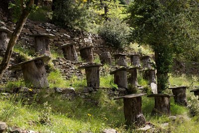
Rucher tronc, la Roquette - © Sandrine Forge Know-howTree-trunk hive (brusc)
Marker 9
Traditional hives in hollowed-out sections of chestnut trunks were placed on a schist slab and closed with a round tilestone. Bees entered through a hole at the base and built their own honeycombs inside, which made it more difficult to harvest honey than in modern hives. The box trees planted around the apiary allowed the insects to feed early (still in winter) on their fragrant flowers. A specific variety, the black bee of the Cévennes, still subsists as a relic in a few isolated valleys. Genetic cross-breeding with imported bees is a very serious threat to its future survival.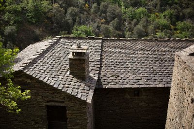
Toiture du Mas Chaptal, la Roquette - © Sandrine Forge ArchitectureRoofs
Marker 10
All the roofs are covered in rectangular or rounded schist tilestones (lauzes), which came from small neighbouring quarries. They are laid using nails (formerly dowels) or simply wedged, depending on the support. The flat or crossed ridges, and the often imposing chimney stacks, give the roofs an inimitable character.- Architecture
The clède and trincat
Marker 11
The clède (a small building for drying chestnuts) made it possible to preserve chestnuts by drying them and thus protecting them from mould and parasites. The chestnuts were poured through an opening in the back gable onto a latticed wood floor. Underneath, on the ground level, was a covered fire giving off heat and smoke. The “path” cut into the rock uphill of the buildings is in fact a water channel. Cutting across the steep slope, it captures runoff rainwater and diverts it, thus protecting the buildings below. Such trincats are also sometimes used as paths by humans and animals.  Flora
FloraHolm oak or yeuse (Quercus ilex)
Marker 12
Forest fires and felling for firewood and charcoal have usually kept holm-oak stands to a modest size. It is therefore rare to see such handsome trunks. These trees would also have been pruned for many years: their leaves were fed to livestock during droughts. Until the 18th century, some groves were used as pasture land (acorns) for pigs, sheep and goats. Like all uniform environments, these groves are rather low in animal species. But you can still see a whole procession of birds: the blue tit and great tit, western Bonelli’s warbler, jay, song thrush, blackbird, robin, wren, etc.- Agriculture
Black mulberry (Morus nigra)
Marker 13
The black mulberry, which is more resistant to late frosts and better suited to altitudes above 500m than the white mulberry, was introduced into southern France in the 5th century. As of the 13th century, it was used for silkworm breeding. If there was a spring frost, farmers could use its leaves to feed the worms temporarily, while waiting for the white mulberry to produce its leaves. The white mulberry replaced the black mulberry in the 15th century, and the latter has almost disappeared from the landscape. Its fruit are succulent, but beware of permanent stains! - History
The Lous Paillous cypress
Marker 14
Lous Paillous consists exclusively of agricultural buildings. The silhouette of the cypress, in the shape of a spearhead, indicates the presence of a Protestant family cemetery. After the revocation of the Edict of Nantes (1685), Protestantism was no longer legal in France, and those Protestants who refused to convert buried their dead on their land. That tradition has continued up to today, although Protestantism was once again recognised at the end of the 18th century. Sometimes the presence of a grave is indicated only by two simple schist slabs stuck into the soil, one near the head of the deceased person, the other near the feet. 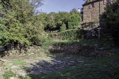
Aire à battre de la Roquette - © Olivier Prohin ArchitectureThe threshing-floor (airol)
Marker 15
Having been levelled, the threshing floor was covered with large schist flagstones so that the sheaves of rye could be beaten and the grain extracted. This was done using a flail or by making donkeys or mules walk on the sheaves. On the valley-side, a raised edge prevented the grain from being blown away. The threshing floor, an open space in a relatively closed environment, is today frequented by the local fauna, especially birds (cirl buntings and redstarts), and reptiles. It is not rare to see a Montpellier snake, sometimes being espied from above by a snake eagle (circaetus).- Water
Le Passet gully
Marker 16
Bancels (crop terraces) and small constructions make it possible to slow down rain runoff and channel it. Here, the stream has a very jagged long profile. The violent autumn storms sorely test these structures, making regular maintenance a necessity. In 2012, very heavy rainfall swept away the bancels and the tapped springs that gave Le Passet gully its shape, creating the current configuration of natural and largely out-of-control gully erosion.  Landscape
The evolution of the landscape
Marker 17
The rural exodus (from the second half of the 19th century onwards), diseases, and a lack of maintenance mean that most chestnut orchards look abandoned. When the trees die, clearings open up and rapidly give way to more dynamic species, such as holm oak, broom, heather, ferns, etc. Wild boar, stags and deer today use the undergrowth, where they feed on fruits and bulbs. Trunks and foliage are much appreciated by nuthatches, mistle thrush, woodpeckers, treecreepers, European pied flycatcher, tawny owl, etc., not forgetting foxes, badgers, genets, and beech martens, which also frequent these environments.- Landscape
Panorama
Marker 18
The hamlet of La Roquette consists of several groups of buildings, which are, from bottom to top: La Moulinarié, Mas Chaptal, Lous Paillous, Mazdal. They were all built from schist and on the mountainside with the best sun exposure. The formerly cultivated land and fields that surround them are immediately hemmed by holm oak, chestnut trees and rocky ridges. The architectural fabric is reinforced by the presence of terraces, which truly anchor the humanised landscape in the natural landscape. On the left, a cross overlooks the valley, bearing witness to the striking events of the Camisard War. At that time, the neighbourhood of La Devèze, to which La Roquette belonged, was a bastion of Catholic resistance in Protestant lands. - History
Château de la Devèze
Marker 19
The oldest part of the Château may date from the 16th century (the mullion window and small tower on the right). The large tower on the left must have been rebuilt after the Camisard War (1702-04) against King Louis XIV’s forces (after the abolition of the Edict of Nantes made it illegal to practise Protestantism). This château at the heart of a Huguenot valley belonged to the Arnal family, from which came the Lords of La Devèze, who had reconverted to Catholicism in 1609. On 28 July 1702, the Château was torched and the entire Arnal family massacred. The pigeon loft reminds us of one of the privileges of Ancien Régime noblemen.
Description
Some clarifications:
• At the car park, walk along the lane for 300 m to the first Marker
• After Marker 2, take the path on the left (narrow, can be slippery when wet)
• Between Markers 15 and 16, the path is narrow
• After Marker 18, take the lane to return to the car park.
- Departure : Car park
- Arrival : Car park
- Towns crossed : Molezon
Forecast
Altimetric profile
Recommandations
Trail currently closed
In summer, it is best to do this walk in the morning.
Some sections are slippery when wet.
The path crosses several private properties. Do not leave the waymarked path. Its continued availability to the public depends on you being discreet.
Horse-riding or mountain-biking are not allowed on or adapted to discovery trails.
Information desks

Tourism'house and national Parc at Florac
Place de l'ancienne gare, N106, 48400 Florac-trois-rivières
This office is part of the National Park's associated tourist-information network, whose mission is to provide information on, and raise awareness of, the sites and events as well as the rules that must be observed in the National Park's central zone.
On site: exhibitions, video projections, events and shop Open year-round

Tourism office Des Cévennes au mont-Lozère, Saint-Germain-de-Calberte
Village, 48370 Saint-Germain-de-Calberte
This office is part of the National Park's associated tourist-information network, whose mission is to provide information on, and raise awareness of, the sites and events as well as the rules that must be observed in the National Park's central zone.
Open year-round, except for 2 weeks at Christmas
Access and parking
D 983 to Pont-Ravagers (12 km from Barre-des-Cévennes and 2 km from Sainte-Croix-Vallée-Française). At Pont-Ravagers, take the lane that leads to Trabassac hamlet (signposted narrow and winding road). About 10 minutes by car from Pont-Ravagers .
Parking :
Calculateur d'itinéraire Lio
Utilisez le calculateur liO pour organiser votre trajet en région Occitanie.
Autres régions
Calculez votre itinéraire en Auvergne Rhône Alpes sur Oùra
Biodiversité autour de l'itinéraire
Source

Report a problem or an error
If you have found an error on this page or if you have noticed any problems during your hike, please report them to us here: