
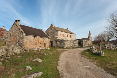
Mas Camargues
The very name of Camargues is intriguing in these uplands. Is it linked to the transhumance (the seasonal migration of livestock to and from mountain summer pastures) that has brought herds from the plains of Languedoc since time immemorial? Or is it a more precise reference to the estates in the Camargue (the wetland plains of the Rhône delta) first of the Knights Hospitaller and then of the Knights of Malta? From the Middle Ages onwards, this order certainly received many gifts of land on the Mont Lozère. Whatever its origins may be, the Mas Camargue is an agricultural estate of over 100 hectares that was very prosperous from the 17th century to the eve of the Great War. Plunge into the very particular atmosphere of the Upper Tarn plain on this path through a landscape that is emblematic of agro-pastoralism.
17 points of interest
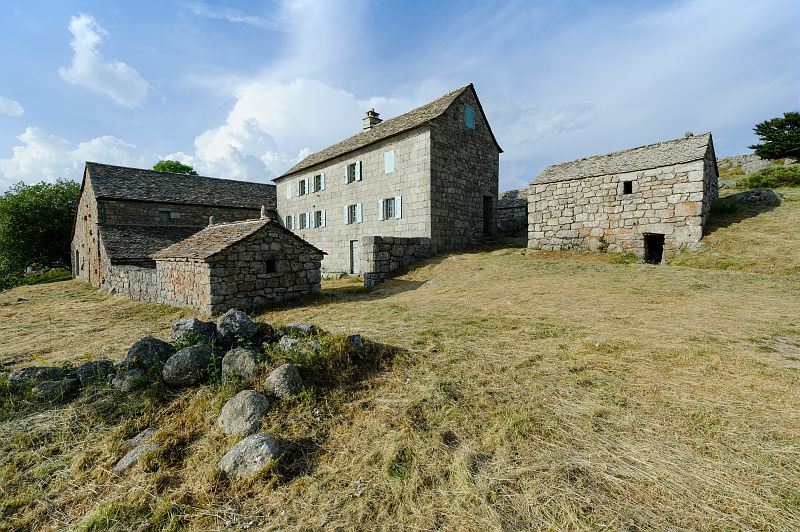
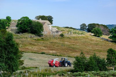
Mas Camargues - © Olivier Prohin  Architecture
Imposing buildings!
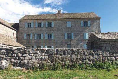
The main building is surprisingly grand in both its dimensions and its façade of carefully carved granite blocks under a curved cornice. Historical records mention the prosperous estate of Mas Camargues as early as the 15th century. However, its current configuration dates from the late 19th century, as the date carved into a lintel shows. If you wander through the neighbouring hamlets, you will understand just how unusual this settlement is on the Mont Lozère. Its owners proudly marked the landscape as no-one had dared to do before them…
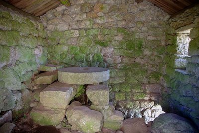
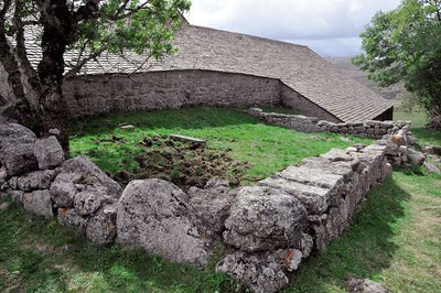
L’intérieur du moulin, la meule fixe est restée sur son axe - © Brigitte Mathieu ArchitectureThe mill
This was a water-powered mill for grinding grain, mainly rye. Like the vast majority of mills on the Mont Lozère, it had a horizontal wheel that was easy to put in operation even with a low head of water. It was first mentioned in the 17th century, and last served during the Second World War. Note the “sleeping” millstone on which the “turning” millstone (no longer extant) ground the rye.
Le béal qui permet à la machine hydraulique de fonctionner - @ Guy Grégoire ArchitectureThe modern hydraulic machine
This building resembles the mill but had an entirely different function, which is testament to the advanced state of technology in Mas Camargues in the late 19th century. The water supply fell onto and turned a vertical paddle wheel, thus creating more power than the mill. The building only housed the “engine” – the energy produced was actually used outside. Imagine a long belt (a wide strap of leather or woven material) that transmitted the energy to a threshing machine set up on the paved threshing floor outside, which separated grains from chaff.
Mas Camargues, Mont Lozère - © Yann Toutain  History
The family cemetery
In a small plot of land enclosed by a low dry-stone wall is a plain gravestone for a little girl who died in 1905. This simple granite slab reminds us of local Protestant tradition. As a result of the 1685 Revocation of the Edict of Nantes (which re-criminalised Protestantism in France), the village cemetery was reserved for Catholics only, and the practice of private Protestant burials became generalised. Some Protestants still choose to be buried in their gardens or fields to this day.
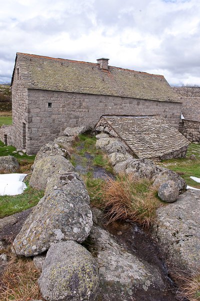
Hameau de Bellecoste entre Mas Camargues et Mas de la Barque - © Guy Grégoire HistoryFrom L'Hôpital to Mas de la Barque
To enable ox-carts and livestock herds to cross the canal, several small bridges were built out of granite slabs. Before the current track was opened up, the path from L’Hôpital to Bellecoste passed through here, upstream of Mas Camargue.
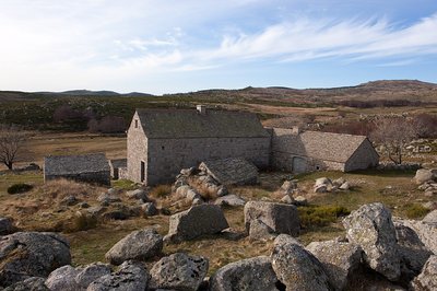
Les bâtiments du mas vus depuis le potager - @ Guy Grégoire  Know-how
The vegetable plot
The vegetable garden, which has lain fallow since the early 20th century, is not easy to spot. It usually consisted of a small plot closed off by stone walls topped by brambles, as protection against animals. A second garden was below the road leading to the Mas. These vegetable gardens are testament to an economy that prioritised self-sufficiency to the greatest possible extent. The main crops were fresh vegetables (carrots, lettuce, etc.) to provide a change from the usual fare of cabbage and potatoes.
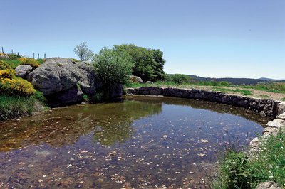
Gourgue de Mas Camargues - © Yannick Manche  Water
WaterThe gourgue and béal
To supply the mills with a sufficient and stable supply of water, a gourgue (reservoir) was laid out using a stone-and-soil levee. A slab with a hole drilled into it let the water flow out. A log with a wooden pole for a handle was used as a cork, ready to be removed whenever milling or threshing were planned. Both upstream and downstream of this reservoir, you can follow the béal, the channel which carries the water from the Tarn all the way to the mills. This system was preferable to using the Tarn’s waters directly, which would have been too dangerous because of the violent floods.
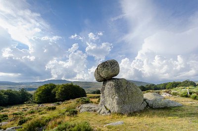
Chaos de granite - © A. BOUISSOU / TERRA Ministère de l'Environnement  Geology
Granite architecture
In the surrounding landscape, here and there, you can see piled-up granite boulders and balls, some of them precariously balanced. These are called block fields (or felsenmeer), geological formations created by a long process of fracturing and erosion of the granite by wind, frost and precipitation. These block fields often supplied the raw materials for house-building, eliminating the need to open up underground quarries. The farmers of the Mont Lozère used granite with great technical skill, as evoked by Jean-Pierre Chabrol in his short story, “Le Crève Cévenne”.
Careful! Do not climb the boulders as their balance is precarious.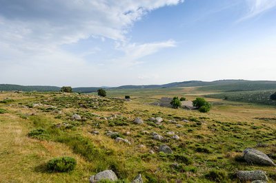
Paturâges sur les hauteurs de Mas Camargues - @ Arnaud Bouissou TERRA Ministère de l'Environnement AgricultureEvolving landscapes
The Mas Camargues landscape is not an unchangeable set, but evolves with land use. In 1813, you would still have seen arable land, fewer pastures and more meadows and gardens, all witnesses to diversified activities. Around 1913, increasing specialisation in livestock rearing, which brought in the largest part of farm incomes, meant that large pastures came to predominate. Tomorrow’s landscape depends on the agricultural choices made. Maintaining livestock breeding is decisive for keeping spaces open; a lack of grazing would lead to an extension first of heath and then of forests.
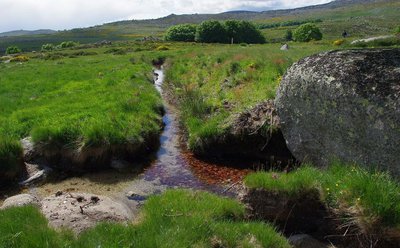
A deux reprises, le béal rencontre un ruisseau. - @ Brigitte Mathieu WaterA water crossing-point
Here, the béal leading to the mills has to cross a tributary of the Tarn. How to stop the béal water from running off down the steeper gradient with the brook water? A simple soil levee damming the brook has created a sort of buffer pond, from which the waters flow in the two directions in acceptable proportions.
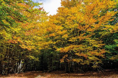
Mas Camargue, Mont Lozère - © Olivier Prohin Know-howCamargues Wood
These woods, mainly beech, do not seem to have changed for centuries. That is hardly surprising once you know that they were only intended to meet the requirements in firewood, tool handles, etc. of the inhabitants of Mas Camargues. They were never commercially exploited in the modern sense. The undergrowth looks quite sparse, but people still harvest blueberries and lichens here.
Le Tarn, près de mas Camargues - © Bruno Descaves WaterThe water intake from the Tarn
A few metres downhill from Marker 12, you can see the small dam built of large granite blocks placed across the Tarn. This raised the water level, so that some of the water ran into the béal. Water usage, whether for irrigation or the mills, was rigorously regulated. The hours of use and the size of the outflow channel were agreed in detail for every property served.
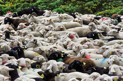
Transhumance, draille de l’Aubaret, Troupeau de Jean-Paul Hébrard - © Olivier Prohin  Pastoralism
Summer transhumance
The pastures that stretch from the edge of the woods to the ridges play host to migrating herds of sheep. The pastoral practice of transhumance is several thousand years old and is being kept alive on all the uplands of Mont Lozère: L’Hôpital, Finiels, Bellecoste, L’Aubaret, La Vialasse, etc.
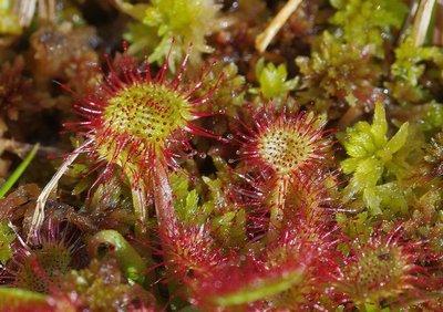
La drosera, plante dite carnivore présente dans la tourbière - © Brigitte Mathieu  Natural environment
A peat bog on the Tarn bank
Peat bogs are of great interest for regulating watercourses, even though they have a rather evil reputation in folklore. They are characterised by particular plant combinations, especially sphagnum, a moss that plays the role of natural sponge.
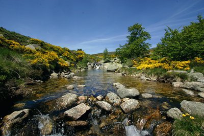
Gourg sur le Tarn - © Brigitte Mathieu WaterA basin in the Tarn
The riverbed of the upper Tarn is a series of more or less sloping planes divided by waterfalls tumbling over large bars of rock, whose contours the water can only smooth away through slow and laborious erosion. One of these granite bars has here created a basin (gourg), a favourite spot for brown trout.
Mas Camagues - © A. BOUISSOU / TERRA Ministère de l'Environnement PastoralismAgro-pastoralism
What is agro-pastoralism? It is a form of agriculture dominated by extensive livestock rearing: herds roam large spaces to feed themselves. Here you can see the distinct zones of the two types of breeding practised on the southern slopes of Mont Lozère: upstream, transhumant sheep on high pastures that are open all the way to the ridges; downstream, predominantly sedentary cattle farming in enclosed parcels of land.
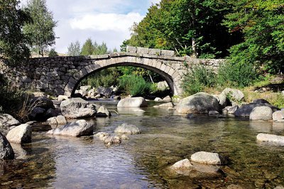
Pont de Mas Camargues, Mont Lozère - © Yann Toutain ArchitectureCamargues Bridge
The pure lines of its arch and the narrow deck are two important elements in giving the least possible hold to the floodwaters of the Tarn. This type of construction has led to the bridge being called “the Roman bridge” in local tradition. However, it was not built before 1850. For the bridge we admire today to have withstood the passage of time and defied the floodwaters of the Tarn since the Roman era would be nothing short of a miracle.
Forecast
Altimetric profile
Recommandations
In summer, the shepherds in this area use guard dogs to protect their flocks from potential predators. Whenever you see such dogs, stop to give them time to notice you. Stay calm, do not threaten them, do not stroke them, and keep your distance from the flock.
Horse-riding or mountain-biking are not allowed on or adapted to discovery trails.
Information desks

Tourism'house and national Parc at Florac
Place de l'ancienne gare, N106, 48400 Florac-trois-rivières
This office is part of the National Park's associated tourist-information network, whose mission is to provide information on, and raise awareness of, the sites and events as well as the rules that must be observed in the National Park's central zone.
On site: exhibitions, video projections, events and shop Open year-round

Office de tourisme Des Cévennes au mont Lozère
le Quai, 48220 Le Pont de Montvert sud mont-Lozère
Transport
It is possible to start the walk in L'Hôpital, a hamlet served by bus line 261 "Florac – Le Pont de Montvert – Mont Lozère".
The service runs every day in July and August https://lio.laregion.fr/
This option adds 3.8 km to the length of the walk.
Access and parking
At Le Pont-de-Montvert, take the D20 towards Mont Lozère. Before you leave the village, turn off towards Villeneuve, L’Hôpital. Go through both of these hamlets, take the track and continue to the car park by the bridge. Walk the last 150 m to the Mas.
Parking :
Calculateur d'itinéraire Lio
Utilisez le calculateur liO pour organiser votre trajet en région Occitanie.
Autres régions
Calculez votre itinéraire en Auvergne Rhône Alpes sur Oùra
Biodiversité autour de l'itinéraire
Source

Report a problem or an error
If you have found an error on this page or if you have noticed any problems during your hike, please report them to us here: