

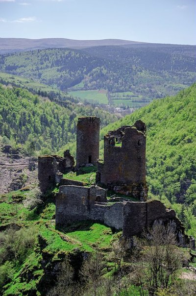
Château du Tournel
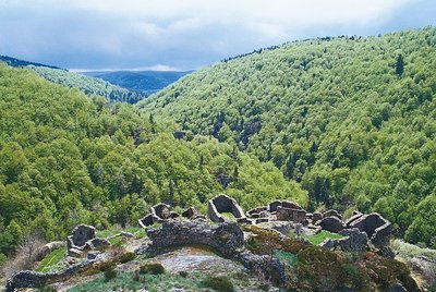
This imposing fortress stands out from the summit of a rocky piton encircled by the Lot. In the 12th century, it was the seat in the Gévaudan of the powerful Le Tournel barony. The site is now home to the vestiges of the castle and village of Le Tournel. In the Middle Ages, the barony's lands extended from Mont Goulet to the Bougès massif and from the foothills of the Causse de Sauveterre to Villefort and the Cèze valley. Beyond its historical importance, the site of Le Tournel also offers us a close look at its geological particularities and ancient architecture, and reveals a vast landscape shaped by human activities past and present.
15 points of interest
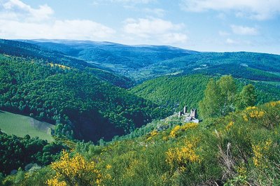
Vue sur le mont Lozère et sur le château du Tournel - @ Guy Grégoire  Landscape
Panorama
Scots Pines, which have replaced oaks on limestone soils and beech on siliceous soils, cover vast areas. With birches, they are the first to invade abandoned farm land. As a result of agricultural decline, vast heaths of broom – which can live on poor soils – have formed. They are periodically subjected to controlled burns by farmers. This landscape evolves over time, and according to natural and human factors.
 Landscape
Panorama
Marker 10
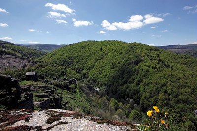
From this high point (above which short-toed snake eagles are often seen), the site of Le Tournel on the rocky spur dominating the Lot Valley, showcases all its strategic power. The surrounding landscape was slowly shaped by human activity, the dispersed settlements favouring the human hold over nature. Mont Lozère’s denuded rounded tops are maintained by the flocks of transhumant sheep that graze here. Crops take up the fertile dips near villages, where farming can be mechanised.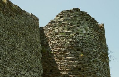
Chapelle castral - © Brigitte Mathieu  Architecture
Chapel and residence
Marker 7
The residence and chapel, the oldest parts of the castle, were built for its religious and residential functions in the 12th century onwards. The castle chapel, dedicated to St Peter, was reserved for the lords' private use. Its barrel vault has collapsed. The choir was integrated into the curtain-wall tower, which shows that it was an element of the castle fortifications, as do its two openings shaped like arrow slits. The residence was lit by semi-circular bay windows with carved yellow-limestone surrounds. Its three floors can still be identified by the anchorage points for their beams. The east wall was defended by a hoarding : a projecting gallery from which the foot of the wall could be defended.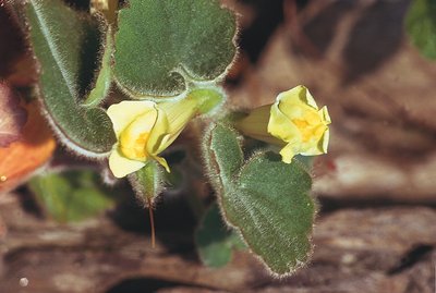
Muflier asaret - @ Yves Maccagno  Flora
FloraA few plants
Marker 9
A few plant species are well-represented near the ruins, such as hoary plantain and mugwort. Among the plants that colonise the almost soil-less stone walls or rock faces are stonecrops (several species, notable for their succulent leaves); saxifrages (three species), which brighten up the rocky outcrops in spring with their white flowers; and navelwort. Trailing snapdragon with its yellow flowers streaked in pink exists almost exclusively in the Cévennes. On top of the tower wall, you will notice two rows of schist stones with rounded lower edges, an exceptional architectural detail. They probably date from the 12th century.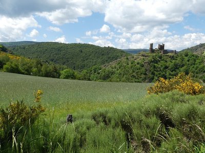
Le château du Tournel - © Nathalie Thomas ArchitectureKeep
Marker 8
The keep and redoubt are defensive elements. Through their massive appearance and their position, they asserted the lords' prestige and power. In the 13th century, the keep was redesigned to have a narrow winding entrance passage and a curtain wall on its west side. The first two floors were each occupied by a rectangular room with a vaulted ceiling and arrow-slit openings. Access from one level to the next was through a manhole. On the second floor, a wall still carries the imprint of the fireplace that once took up the whole back wall. A turret built onto the keep contained a spiral staircase that gave access to the third floor.- Architecture
Redoubt
This tower was probably necessary to fortify the castle during the Hundred Years' War. Its extremely thick walls (1.7 m as compared to 80 cm for the residence) reinforce a corner of the castle wall and served as the last line of defence. They follow the contours of the vertical cliffs. The tower still shows the vestiges of three corbels just above the access door, which must once have supported a bretèche (small defensive balcony). Inside, the floors separated by vaulted ceilings are accessible through manholes.
 History
Traffic axes
Marker 6
Le Tournel is situated in a landscape that is covered by a network of traffic axes: two drailles (drovers' roads) and the Via Soteirana linking Villefort with Mende. Because of its geographical position, the Château du Tournel was a dominant feature and played a prominent role in monitoring the territory, its people and their movements. The Via Soteirana, a former Royal road, seems to have been crucial for mining operations in the surrounding area. It was also a non-negligible source of income for the castles built at intervals along it, because of the tolls imposed on every user.- Architecture
Watchtower
Marker 5
The similarities in construction between the watchtower and the keep date both buildings to the 13th century. The tower, part of the first settlement of the site, served as the advance defences of the original village. Later it found itself at the centre of the site, and from there protected and controlled the one-road village. Its walls are 1.2 m thick and the closing system of the door – with a sliding bar – can still be seen. Probably damaged during a fire, it was transformed into a dwelling with two storeys, separated by a wooden floor that replaced the destroyed vaulted ceiling. The anchorage points for its joists can still be seen in the masonry.  Geology
Rock with cup marks
Marker 4
Below this barite boulder, which blocks access to the spur and thus protected the castle and original village, there is a rock with nine circular holes of varying sizes: cup marks. They are not placed in any particular pattern and do not seem to have been used as anchorage points. Could erosion have hollowed out the rock in this way? This phenomenon exists in many places In the Cévennes, always in schist. When nature reclaims rock faces, it first establishes lichen there. These crust-like organisms with their various colours cause the rock to crumble, which is necessary for other plants to be able to establish themselves.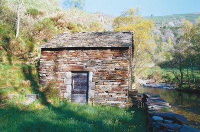
Le moulin restauré de Saint-Julien-du-Tournel - @ Guy Grégoire HistoryMill
In feudal times, villagers using mills had to pay a fee to their lord. From the French Revolution onwards, mills became the joint property of locals, who were responsible for their upkeep. Le Tournel mill with its schist walls and roof was built below the village, a few steps from the Lot, in 1820. Powered by water flowing through a béal (open channel), the mill produced rye and wheat flour before each bread-baking, bread being the basis of the local diet. In about the mid-20th century, these mills stopped being used. Le Tournel mill, which was well-preserved, has recently been restored.
@ Yannick Manche HistoryThe site is abandoned
From the 13th century on, the local lords preferred the more comfortable Château du Boy while some inhabitants chose the security of the city of Mende over the protection afforded by castles. The steep location of the village, the demographic crises of the 14th and 15th centuries, the plague, and the end to territorial conquest may also explain the gradual abandonment of the site. In the 19th century, only a few houses were still inhabited, and the land was barely used. The one-road village was definitively abandoned in 1930, when today's hamlet of Le Tournel was built along the western slope of the spur.
Château de Saint-Julien-du-Tournel - © Guy Grégoire ArchitectureOne-road village
Marker 3
Gradually, the village re-established itself alongside the cart track that crossed the rocky spur and made trade possible, taking on the appearance of a “one-road village”. The track was paved with schist in places and followed the Lot valley to the neighbouring parishes and hamlets. The houses are arranged in a crown shape; their gable ends face out over the cliff. They are separated by enclosed gardens and small squares of sorts. These block-like houses – large and austere two-storey buildings – only have very few openings that always face south and are built to the same model: narrow slits with a simple inward splay, topped by a lintel.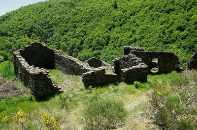
Ruines - © Brigitte Mathieu ArchitectureEstablishing the original village
The first village was built at the foot of the castle, on the narrow strip of the ridge between the castle and the block of rock that closes off the spur to the south. Thus protected by its inaccessibility, the village was never surrounded by an internal rampart. Its buildings can still be made out in some places, where the rock is shaped into anchorage points, and consisted of small houses built in parallel to the rock faces so as integrate them in the construction. This original accommodation was abandoned in the 13th century, badly served by its inacccessibility and the strong winds buffeting it. The houses were levelled off, their walls becoming terrace walls.
@ Olivier Prohin HistoryDefensive choices
Marker 2
In the 11th century, the King's authority was declining. Secular land-owning lords built fortresses to protect their assets and the people for whom they were responsible. The castrum or castle of Le Tournel was built at an altitude of 1,080 m, surrounded by a loop in the river Lot that is impossible to skirt. It occupies a rocky spur surrounded by sheer drops on all sides except the north. The vertical rock faces of the east and west sides make accessing the castle extremely dangerous. The site itself was the mainstay of the castle's defences, and enabled it to dominate and survey the Lot valley.- Geology
Schist: bedrock and material
Marker 1
At Le Tournel, mica schist is ever-present. Between 220 and 200 million BC, when the Hercynian mountain chain emerged, rock was dragged into the depths by folding and subjected to high temperatures and pressure, which transformed it into schist and mica schist. These finely foliated rocks are made of quartz and mica, and break off in slabs that resist the cold, water and frost, making them excellent construction materials. They provided the raw materials for building both castle and village. Several quarries are still in use locally and supply wall, flooring and roofing materials.
Description
Some clarifications:
• Your starting-point is opposite the car park – you need to cross the road at the tunnel exit
• From Marker 3, you can join the mill on the bank of the river Lot via a staircase (there-and-back)
• From Marker 9, you can join a belvedere that overlooks the site of Le Tournel and allows you to read the landscape.
- Departure : Car park
- Arrival : Car park
- Towns crossed : Mont Lozère et Goulet
Forecast
Altimetric profile
Recommandations
Horse-riding or mountain-biking are not allowed on or adapted to discovery trails.
Information desks
Tourism office Coeur de Lozère, Mende
BP 83, place du Foirail, 48000 Mende
This office is part of the National Park's associated tourist-information network, whose mission is to provide information on, and raise awareness of, the sites and events as well as the rules that must be observed in the National Park's central zone.
Open year-round

Tourism office Mont-Lozère, Bagnols-les-Bains
avenue de la gare, 48190 Bagnols-les-Bains Mont-Lozere et Goulet
This office is part of the National Park's associated tourist-information network, whose mission is to provide information on, and raise awareness of, the sites and events as well as the rules that must be observed in the National Park's central zone. Open from mid-April to late September
Access and parking
D 901 between Bagnols-les-Bains and Le Bleymard
Parking :
Calculateur d'itinéraire Lio
Utilisez le calculateur liO pour organiser votre trajet en région Occitanie.
Autres régions
Calculez votre itinéraire en Auvergne Rhône Alpes sur Oùra
Biodiversité autour de l'itinéraire
Report a problem or an error
If you have found an error on this page or if you have noticed any problems during your hike, please report them to us here: