
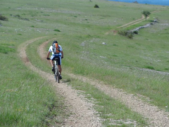
The Causse Loop (by mountain-bike)
This trail is entirely on the Causse Méjean. It goes through the steppe-like landscape that is specific to the Causses plateaux. Natural Scots-pine forests and planted black-pine forests dot the route and bring some shade. You can see handsome traditional farms and typical hamlets built entirely from limestone.
11 points of interest

 History
Early transformation of the landscape
About 5,000 years ago, agriculture was already well established on the plateau. Evidence for this has been found in the remains of the cave and swallow-hole settlements of the period: large carved-stone sickles, food storage jars wrapped tightly in rope, and carbonised grains (barley, several varieties of wheat, etc.). Alongside cereals, people ate the products of livestock rearing (mutton, beef, pork), fishing (salmon) and hunting (stag, roe deer, ibex, brown bear, beaver, hare, rabbit, Western capercaillie, etc.), the latter suggesting a much more forested environment than today.
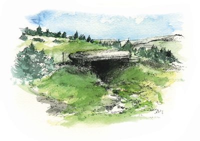
Dolmen du Pradal - © Olivier Prohin  Archaeology
Traces of early man
The Pierre Plate Dolmen was built about 2600 BC. Dolmens are collective tombs that must also have played an important role in the identity and cohesion of the social group that built them (called the Treilles Group by archaeologists, after the name of a cave that it once occupied). These tomb builders were caving pioneers: they ventured into the depths of swallow holes to get water and clay. They were also innovators, producing very beautiful stone arrowheads shaped like fir trees and soon afterwards learning to fashion copper (arrowheads, daggers, axes).
 Landscape
Forests spreading steadily
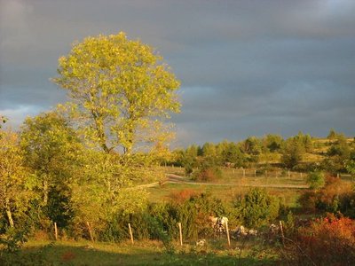
On the valley floors there are still some fairly large expanses of farmed meadows, but some of the space has been urbanised. Other arable surfaces, “suspended” mid-slope, depend for their upkeep on the farmers who live in the isolated villages. On the slopes, the forested areas in their mix of oak, chestnut and conifers form a pattern marked by different era. Short-grass prairies are persisting on high ground, and heath covers siliceous soils.
- Landscape
Mont Lozère
From the plateau, you can see all of Mont Lozère. At 1,699 m, the Pic de Finiels is the department's highest point. Mont Lozère stretches for some thirty kilometres, west-east from the Causse de Sauveterre to Villefort, and south-north from Le Pont de Montvert to Le Bleymard. It is an exclusively granite massif, on which the river Tarn has its spring.
Vue depuis le Tomple - © Virginie Boucher  Architecture
Le Tomple
The houses in this hamlet (altitude 976 m) have been built from limestone blocks using a lime mortar. Some have been rendered. Such construction methods are characteristic for traditional architecture. The stones for building came from the plateau's quarries. The lack of wood forced builders to do without: no timber roof structures, just a stone vault covered by lauzes (flat stones). Traditionally made from limestone, these lauzes started to be replaced by schist lauzes a few years ago. These techniques mean that Causse houses are solidly built, with only small openings.
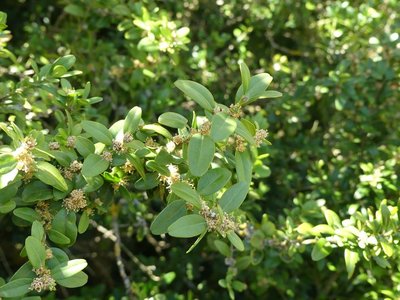
Buis - nathalie.thomas  Flora
FloraBox
Box is a symbol of immortality because it is evergreen. In the Middle Ages, it was a part of the peasants' materia medica. Its essence, wood and leaves all have the same characteristics. Dried in the shade with frequent turning, its leaves were a remarkable antipyretic and diuretic with sudorific properties. They were also used to treat chronic skin diseases, gout, rheumatism and baldness. Branches were used as litter in sheepfolds. During the summer grazing period, the shepherds turned its wood into staffs with sculpted knobs and other objects.
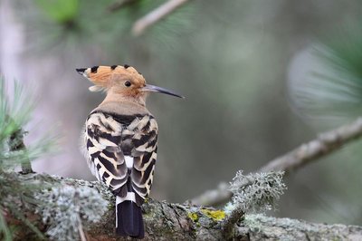
Huppe facié - © Régis Descamps  Fauna
Fauna(Crested) hoopoe
This resplendent bird deserves its name, with its feathery crest on its head. It has a slender beak that it uses to extract larvae and insects from the ground. Its plumage is distinctive: an orangey dark pink, with black-and-white-striped wings and back. It is very difficult to observe, but can be identified by its characteristic call of oop-oop-oop. Locals call it poupoune. The hoopoe is a migrating bird.
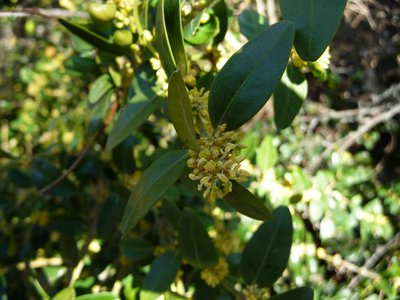
Fleur de buis - Nathalie Thomas  Natural environment
Boxwood
The scientific name of boxwood, Buxus semperviens, means “always green”. It is the best-known shrub on the Causses but also the most invasive. Its small shiny leaves limit water loss in the heat. Box is low-maintenance and tolerates poor and dry soils as well as wide temperature variations. It invades pastures; sheep do not like its leaves at all. It is hard to get rid of, and only the regular trampling of the flocks stops its progress. In the old days, it was sometimes used as manure on fields.
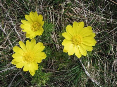
Adonis vernalis - © Bruno Descaves FloraAdonis vernalis (spring pheasant's eye)
Whilst this member of the buttercup family might seem plentiful, it has become rare and is limited to a few places in France (Causses, Alsace) and south-eastern Europe. It can be seen in April-May in the steppe flora. This plant is protected – you may take photos but under no circumstances take the plant! It secretes a substance through its roots that tends to limit the growth of plants around it, especially legumes.
- Architecture
Nivoliers
This traditional Causse Méjean hamlet has a dozen year-round residents, who mostly work in tourism (gîtes, chambres d'hôte, inn, grocer's shop) and agriculture (flocks of sheep, honey, jams, etc.).
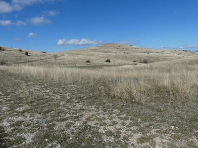
Mont Gargo - nathalie.thomas LandscapeThe summit of Mont Gargo
At 1,274 m, this is the highest point of the Causse Méjean. As you pass Cros Roux, you are only metres away! This isolated, austere and wild high ground goes right to the edge of the cliffs overlooking Florac. It drops off to the north, where large isolated farms are sheltered in deep dolines (depressions). Vast black-pine plantations – a total break with the steppe landscape – today cover the whole west of the massif and many knolls to the north. About 40 years ago, following the decline of agriculture, these large production units of resinous trees replaced the agro-pastoral landscapes.
Description
Mountain-bike route # 2. From the Col de Pierre Plate, go down a small technical descent to join up with the road leading to Le Tomple. Go through the hamlet and continue to La Condamine. At the crossroads with the road going towards Montbrun, go left for a few metres, then turn right onto a small path. Join up with the track leading to Fraissinet-de-Poujols. Go through the hamlet and turn right towards Poujols. Continue straight all the way to Chaldas. After Chaldas, at Point 1015, take the path going downhill to Chamblon. Go into the hamlet and continue on the road (GR 60) and then on the track (GR 60). Cross the D 16 and skirt Le Fraisse farm to get to Nivoliers. In Nivoliers, head towards Cavaladette on a former village track. Below Cavaladette, take the road and, at the cross, turn right onto the track leading to Cavalade, Cros Roux, Cros Garnon. In Cros Garnon, pass in front of the church before going first to La Mecoire and then to Valbelle. Take the D 16 for 3 km to return to the car park at the Col de Pierre Plate.
- Departure : Col de Pierre Plate pass
- Arrival : Col de Pierre Plate pass
- Towns crossed : Florac Trois Rivières, Gorges du Tarn Causses, Mas-Saint-Chély, Hures-la-Parade, and Vebron
Forecast
Altimetric profile
Recommandations
No cycling off-track. Trails are stony and at times steep. You are strongly advised to wear a helmet. Do not forget your repair kit and a small set of tools. Be careful around flocks and dogs. Please shut all gates and barriers behind yourself. Slow down in farms and hamlets. Carry water.
Access and parking
From Florac, drive up the D16 to the car park at the Col de Pierre Plate pass
Parking :
Calculateur d'itinéraire Lio
Utilisez le calculateur liO pour organiser votre trajet en région Occitanie.
Autres régions
Calculez votre itinéraire en Auvergne Rhône Alpes sur Oùra
Biodiversité autour de l'itinéraire
Source


Report a problem or an error
If you have found an error on this page or if you have noticed any problems during your hike, please report them to us here: