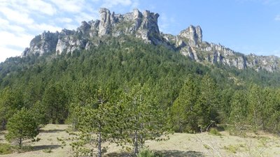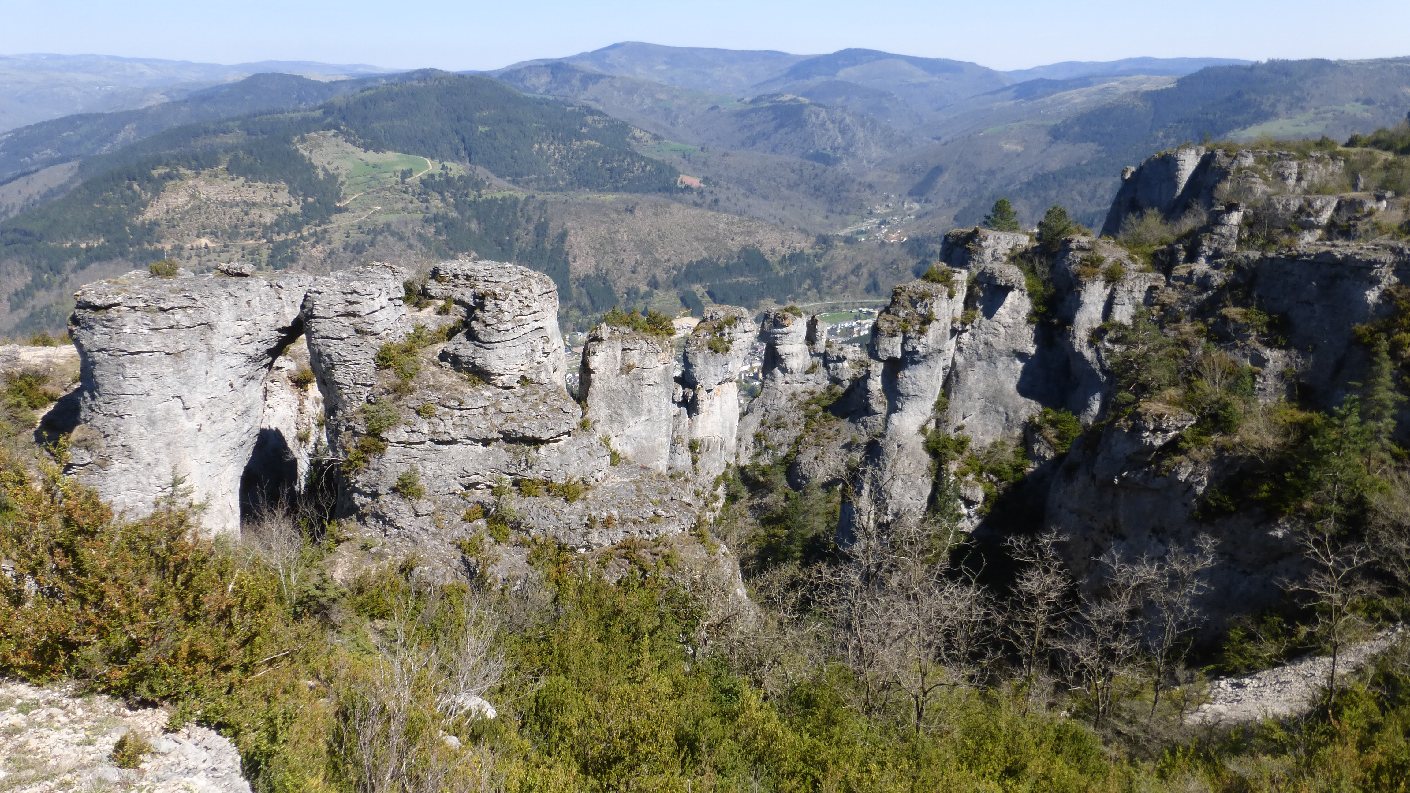
The clifftops
This trail leads at the foot of the plateau of the Causse Méjean, which offers viewpoints towering over the valley of Florac and the spectacular “crowns”. On the horizon, the Cévennes and Mont Lozère stand out as a series of planes to infinity.
9 points of interest
La source du Pêcher - PROHIN Olivier  Water
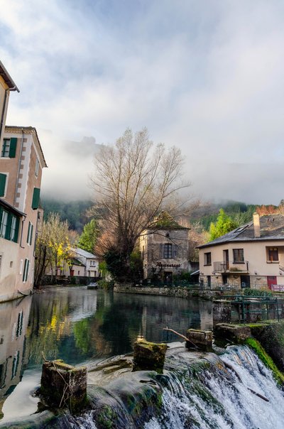
WaterThe river Vibron
This river has been used as the drinking-water supply for the town’s many fountains, to irrigate its gardens, power up to eight water mills and provide water for a fish farm. In the old days, it was also used for public wash-houses, tanneries and as a drain for waste water.
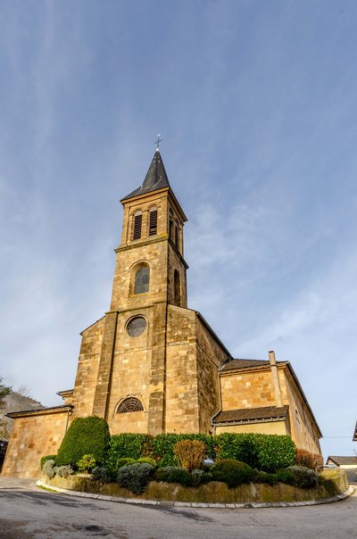
PROHIN Olivier  Architecture
Saint-Martin's Church
The original church, the Chaise-Dieu Priory church, stood on the site of the current church, surrounded by a cemetery. Between the 13th and 15th century, Florac was known for the power struggle between its priory and its lord, who lived on the other side of the Bibrou (Vibron) river. The church was destroyed in 1561 and a temple (Protestant church) built on its vestiges. Florac was devastated many times by religious wars: the temple, the clock and the church tower were all destroyed at the beginning of the 17th century (1629). The current Catholic church, built in the neoclassical style, dates from 1833, just like the temple on the Esplanade.
Les couronnes - © com com Florac Sud Lozère  Flora
FloraWell-adapted flora
A flora typical for these dry chalky slopes is colonising the pastures: box, juniper, shadbush (Juneberry), briar and blackthorn. These plants content themselves with thin soils but need light. They are well-adapted to drought and heat. The harsh conditions under which these shrubs live is reflected in the toughness of their wood, which is often used for wood-turning or cane-making.

 Landscape
Forests spreading steadily
On the valley floors there are still some fairly large expanses of farmed meadows, but some of the space has been urbanised. Other arable surfaces, “suspended” mid-slope, depend for their upkeep on the farmers who live in the isolated villages. On the slopes, the forested areas in their mix of oak, chestnut and conifers form a pattern marked by different era. Short-grass prairies are persisting on high ground, and heath covers siliceous soils.
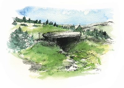
Dolmen du Pradal - © Olivier Prohin  Archaeology
Traces of early man
The Pierre Plate Dolmen was built about 2600 BC. Dolmens are collective tombs that must also have played an important role in the identity and cohesion of the social group that built them (called the Treilles Group by archaeologists, after the name of a cave that it once occupied). These tomb builders were caving pioneers: they ventured into the depths of swallow holes to get water and clay. They were also innovators, producing very beautiful stone arrowheads shaped like fir trees and soon afterwards learning to fashion copper (arrowheads, daggers, axes).
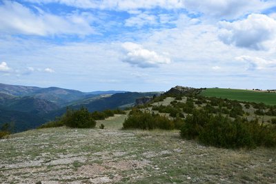
- Landscape
A crossroads of evolving landscapes
To the west and northwest, you see the Causse Méjean and Causse Sauveterre; further west, the Causse Noir and the Causse du Larzac. On these large, creviced limestone plateaux, water rapidly disappears into the ground and from there into rivers, which have carved out impressive gorges. Straight ahead in the far distance is Mont Lozère, which gave its name to the département. Where the Causses are arid, Mont Lozère is covered by a network of streams (cf. Runes and Lozérette waterfalls) that irrigate its meadows. In between the two lie the abrupt silhouettes of the Tarn, Mimente and Tarnon valleys.
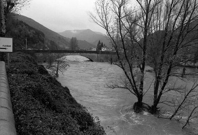
Inondation de Florac du 13 et 14 décembre 1982 - © Guy Grégoire WaterA network of rivers
Over 50,000 hectares of mountainside with countless little streams issuing from the tiniest springs drain into the Tarn and its tributaries downstream of Florac. These rivers all belong to the Atlantic side of the watershed: their water flows into the Atlantic. Their rate of flow is more even than that of the Cévenol rivers belonging to the Mediterranean basin. On the Atlantic side, the average slope is moderate and the climate fairly regular, whereas the Mediterranean side has more abrupt gradients and storms with heavy rainfall in autumn and spring. Between them lies an intermediate zone which blends both characteristics, as it does here.
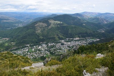
Vue sur Florac - com com Florac Sud Lozère  History
The town of Florac
and has as many inhabitants today as it did at the end of the 19th century (about 2,000). Some of the alluvial terraces of the river Tarnon are the chosen areas for urbanisation now. The château, which dates from the 13th century, is home to the headquarters of the Cévennes National Park.
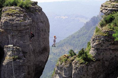
Via ferrata du Rochefort - Yannick-Manche LandscapeStill the best: the Rochefort via ferrata!
The company Cévennes Evasion, based in Florac, has created the Rochefort via ferrata on the Rochefort and Ron Picard rocks. Inaugurated in June 2013, the via is considered one of the most beautiful in Lozère. Its users say:
“The one at Rochefort Florac is just unique, magnificent and extraordinary. Truly Extremely Difficult++ for once. Not for beginners and sensitive souls. The overhang is unique, unbelievable, sensational!” (M-A)
“Great scary via, especially the final overhang (wicked)! Finally a real, full-throttle Extremely Difficult via, with your legs dangling in thin air. A magnificent setting, with vultures that didn’t get us! An absolute must-do!! And well done to the creators for the many exits, which make it accessible for all levels.” (P & Y)
Description
Starting at the Maison du tourisme et du Parc (joint tourism office and National Park information centre) in Florac-Trois-Rivières, cross the RN 106 main road. Take the metal footbridge and keep straight ahead until you reach the Esplanade. Turn left and walk to the square. Take Rue du Quai and, at the crossroad, go straight ahead onto Rue de Remuret, which goes uphill to the Catholic church. Keep going uphill until you reach the D 16 road.
- Turn left onto the road, and go past the council workshops and the entrance to Paul Arnal Park. After the bend, turn left. 200m later, the path rejoins the D 16. Cross the road and continue to climb straight ahead, crossing the road 4 times.
- Below the ledge of the Causse plateau, head towards Mas Rouchet for 80 m. Then turn left onto the path leading to the dolmen on the edge of the Causse road. Turn left onto the road and follow it to the hairpin bend.
- Follow the path that goes below the Causse ledge. For the first 400 m approximately, the path is steep and built with steps. Then it goes across the slope below the plateau ledge to the via ferrata at Le Rochefort.
- Once on the flat area, ignore the path that goes up onto the Causse and go straight ahead on the path that hugs the slope, below the plateau ledge but above the cliffs.
- At the crossing, take the path on the left that zigzags downhill amidst the cliffs to the hamlet of Croupillac.
- Above the hamlet, the path veers left. At the far side of the meadow, turn left, go through the electric fence and follow the path that stays at mid-height on the side of the Causse. (NB: horse pasture, electric fence). The path crosses a track, goes downhill on the right, then goes through a meadow and rejoins the track.*
- 80m later, you leave the track, turning onto a path on the right, which zigzags downhill towards the hamlet of Le Viala de Grimoald. At the path, turn right and, at the road, turn left, going uphill towards the houses. Once you have left the hamlet, turn right: the path joins up with the D 907.
- Turn left to return to Florac. At the roundabout, go straight. As you reach the Collège (secondary school), fork left onto Rue du Pécher, then return to the Esplanade and the joint tourism office and National Park information centre.
- Departure : Florac
- Arrival : Florac
- Towns crossed : Florac Trois Rivières
Forecast
Altimetric profile
Recommandations
Caution: steep climb, with a craggy and stepped first section below the clifftops. Some vertiginous sections. The descent to Croupillac is stony.
Make sure your equipment is appropriate for the day's weather conditions. Remember that the weather changes quickly in the mountains. Take enough water, wear good shoes and put on a hat. Please close all gates and barriers after yourself.
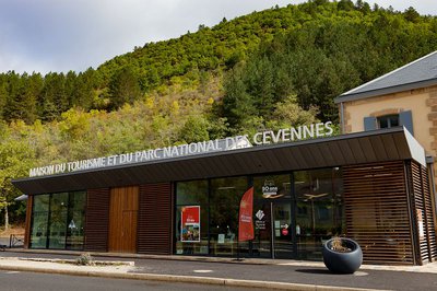
Information desks

Tourism'house and national Parc at Florac
Place de l'ancienne gare, N106, 48400 Florac-trois-rivières
This office is part of the National Park's associated tourist-information network, whose mission is to provide information on, and raise awareness of, the sites and events as well as the rules that must be observed in the National Park's central zone.
On site: exhibitions, video projections, events and shop Open year-round
Transport
Bus stop: Florac, Place ancienne gare
Bus line 258 “Florac – Sainte-Enimie – Le Rozier”, every day in July and August
Bus line 261 “Florac – Le Pont de Montvert – Mont Lozère”, every day in July and August
Bus line 251 "Florac – Mende”
Year-round daily service Monday to Saturday
Bus line 252 “Ispagnac – Florac – Alès”
https://lio.laregion.fr/
Access and parking
RN106: Car park in front of the Maison du tourisme et du Parc (joint tourism office and National Park information centre) in Florac-Trois-Rivières.
Parking :
Calculateur d'itinéraire Lio
Utilisez le calculateur liO pour organiser votre trajet en région Occitanie.
Autres régions
Calculez votre itinéraire en Auvergne Rhône Alpes sur Oùra
Biodiversité autour de l'itinéraire
Source


Report a problem or an error
If you have found an error on this page or if you have noticed any problems during your hike, please report them to us here: