
Fontmort
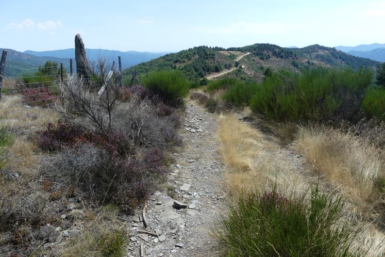
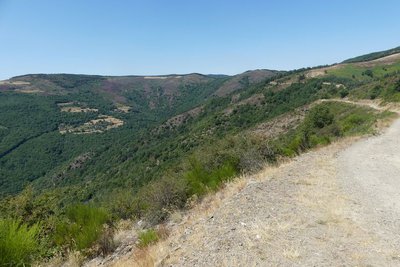
This path leads hikers in the footsteps of the Camisards and onto the ridges of the Cévenol valleys. It offers spectacular views over the valley of the Gardon de St-Martin all the way to the white cliffs of Anduze and Mont Aigoual. It crosses woods, chestnut groves and heaths, which once upon time were pastureland and orchards. It runs alongside a river where you may meet herds of goats, and offers a uniquely comprehensive, panoramic view of the Cévenol valleys.
4 points of interest
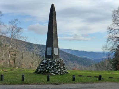
Obélisque du Plan de Fontmort - © Nathalie Thomas  History
Plan de Fontmort Obelisk
This commemorates the centenary of the Edict of Tolerance, through which Louis XVI granted Protestants their religious freedom. It was erected on this symbolic site, where several battles took place during the Camisard War. In 1702, Royal troops surprised a group of Camisards, whose leader, Esprit Séguier, they captured; he was burned alive. In 1703, the Camisards attacked Royal troops escorting a messenger and killed the soldiers. In 1704, 500 Camisards ambushed 300 soldiers, over 100 of whom were killed. (P. Grime)
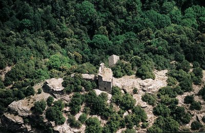
Fontanille - © Pierre Lahoue  Architecture
The ruins of Fontanille tower.
The ruins of this tower stand out against the rocks. The tower's general shape is typical of 12th-century military architecture. It is believed to have had three functions: as the keep of a castle that has mostly disappeared; as a chapel (still extant at the foot of the tower); and as a signal tower. (P. Grime)
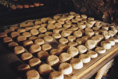
Fromage de chèvre - © Parc national des Cévennes AgriculturePélardon cheese
In this valley, goats are the predominant livestock. Their milk is sold to the cooperative dairy in Moissac Vallée Française, or turned into Pélardon cheese on the farm. Pélardon was awarded the AOC (controlled designation of origin) in 2000 and the AOP (protected designation of origin) in 2001. This small round cheese made from unpasteurised whole goat's milk is an emblem of the Cévennes. Since goats offer a better financial return, herds of goats are smaller than flocks of sheep. They maintain smaller grazing surfaces, but need richer fodder to supply milk. (P. Grime)
Vallée de Trabassac - nathalie.thomas HistoryTrabassac valley
From the ridge, your eye is drawn downwards and southwards into Trabassac valley. From the 1970s onwards, this valley became home to young people looking for new values based on nature and a community spirit. Some nicknamed it “the valley of the hippies”. Nowadays, horses are bred there. Deciduous trees are starting to invade the heath from the most rugged small valleys. (P. Grime)
Description
At the Plan de Fontmort, take the path southeast of the obelisk, which leads to the spring of the Gardon de St-Martin. The path crosses the river several times, then leaves it behind to head for a small valley. The path then winds through the chestnut grove before joining a larger track onto which you turn right. Further on, ignore a path going uphill on the right. Shortly after a small valley, take the first path on the right, which joins the road. Turn right onto the road. Then take the first path on the left, which goes uphill in zigzags. The path joins a track onto which you turn left. After 2 hairpin bends, the track arrives on the ridge. Here, turn right onto the track that follows the ridge. After 750 m, leave the main track to take a path on the right that climbs alongside a fence to the highest point of the ridge. Walk back downhill on the first firebreak, on your right, to return to the Plan de Fontmort.
- Departure : Plan de Fontmort
- Arrival : Plan de Fontmort
- Towns crossed : Saint-Martin-de-Lansuscle, Molezon, Barre-des-Cévennes, and Cassagnas
Forecast
Altimetric profile
Recommandations
Make sure your equipment is appropriate for the day's weather conditions. Remember that the weather changes quickly in the mountains. Take enough water, wear good shoes and put on a hat. Please close all gates and barriers after yourself.
Information desks

Tourism office Des Cévennes au mont-Lozère, Sainte-Croix-Vallée-Française
Mairie, 48110 Sainte-Croix-Vallée-Française
This office is part of the National Park's associated tourist-information network, whose mission is to provide information on, and raise awareness of, the sites and events as well as the rules that must be observed in the National Park's central zone. :
Open year-round
Access and parking
On the D 13, 6 km from Barre-des-Cévennes towards St-Germain-de-Calberte
Parking :
Calculateur d'itinéraire Lio
Utilisez le calculateur liO pour organiser votre trajet en région Occitanie.
Autres régions
Calculez votre itinéraire en Auvergne Rhône Alpes sur Oùra
Biodiversité autour de l'itinéraire
Source

Report a problem or an error
If you have found an error on this page or if you have noticed any problems during your hike, please report them to us here: