
The Rocher de l'Aigle (Eagle's Rock)
4 points of interest

 Flora
FloraThe forestry track
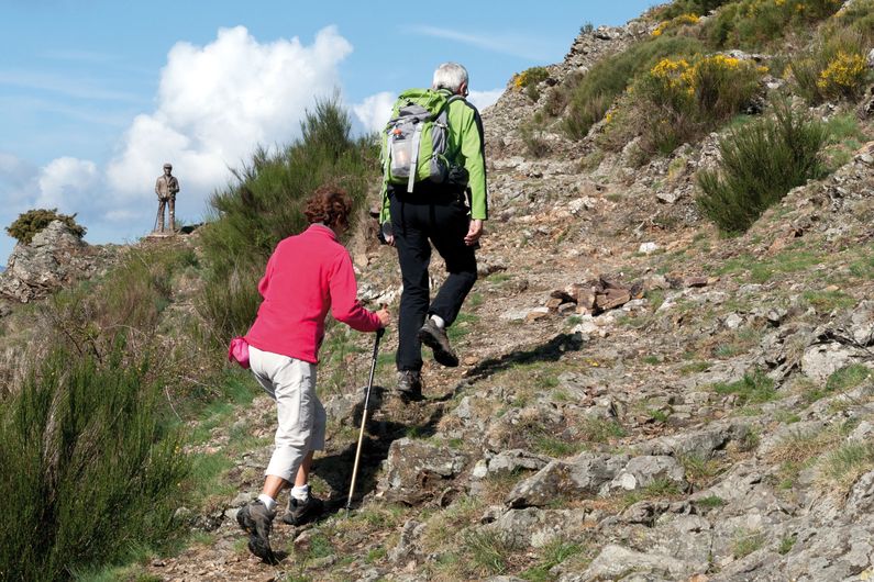
On the first two kilometres, up to the Rocher de l'Aigle, you are on the forestry track opened in 1938. Where there are forestry tracks, there are state-owned forests, meaning forests managed by the French state and the Office National des Forêts so as to develop the area. The presence of so many beech trees and pines is a marker of the previous reforestation policy on the Aigoual massif and in the Cevenol foothills. A plaque has been erected at the Col du Fageas pass, further along this trail, in memory of Max Nègre (1880 – 1960), one of the project managers of this collective undertaking. From 1935 to 1939, he thinned out the forests planted since the end of the 19th century and opened up forestry tracks.
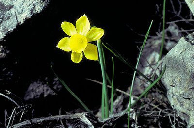
Narcisse à feuilles de jonc - © Yves Maccagno FloraRush-leaf narcissus
Come in spring – up to the end of April – to see the rush-leaf narcissi opposite the Rocher de l'Aigle. They grow in abundance on the limited surface area of the sheltered and south-facing stony slope. Often there is only one fragrant flower per plant. Do not pick them! Take a photo instead!
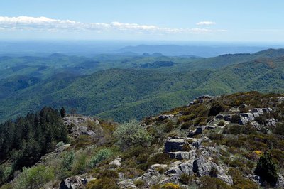
Vue panoramique - © Olivier Prohin  Landscape
Panoramic views
Enjoy a superb 360° view! On the northern horizon, you can see the summit of Mont Aigoual and, on the valley floor, the hamlets of Les Millerines and L'Abric in the foreground and a part of the districts of L'Estréchure and Saumane in the middle distance. Further north, the village of St-Roman-de-Tousque is perched on the long corniche of the Cévennes. To the east, you can make out the city of Alès, Mont Bouquet and, in the distance, the “giant of Provence”, Mont Ventoux (1,912 m).
On the southern horizon are two limestone hills: the Jumelles de Monoblet. Behind them, Coutach hill overlooks Sauve and Quissiac. The Pic Saint-Loup rises above it all with its 658 m. You can also see a stretch of coastline, with the salt marshes of Aigues-Mortes and La Grande-Motte just visible. Further west, the Roc Blanc rises next to the Pic d'Anjeau. And finally, just opposite you, Mont Fageas, the summit of the Liron range, on which you have been walking west-to-east for an hour already.
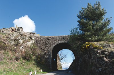
Pont moutonnier - © Olivier Prohin  Pastoralism
Sheep bridge
This bridge was expressly built in the 19th century for shepherds heading from the plains of Languedoc to greener regions in the summer. Following the mountain ridges with their flocks, they ascended to the summer pastures. This draille [drovers' road], the Draille de la Margeride, is one of the most famous in the Cévennes alongside those leading to the Aubrac and the Gévaudan.
Description
Signposts will guide you all along this route, as well as yellow painted waymarks. In the description below, the signposted place names and/or directions are given in bold italics between quotation marks:
From the “Col de l’Asclier”, head towards:
- “La Faïsse” via the GR®61 trail towards
- “La Cale” (leave the GR®61), and turn right towards
- “Rocher de l’Aigle” (detour to the viewpoint).
Continue to - “Col du Fageas”. Turn right onto the GR®67 trail towards
- “Source de l’Asclier”, then return to “Col de l’Asclier”.
- Departure : Col de l'Asclier
- Arrival : Col de l'Asclier
- Towns crossed : Les Plantiers, L'Estréchure, Soudorgues, and Val-d'Aigoual
Forecast
Altimetric profile
Recommandations
Make sure your equipment is appropriate for the day's weather conditions. Remember that the weather changes quickly in the mountains. Take enough water, wear solid shoes and put on a hat. Please close all gates and barriers after yourself.
Information desks

Tourism & national parc'house
Col de la Serreyrède, 30570 Val d'Aigoual
The Maison de l'Aigoual houses the tourism office Mont Aigoual Causses Cévennes and the Maison du Parc national. This visitor centre provides information on and raises awareness of the Cévennes National Park, its sites and events as well as the rules that must be observed in the National Park's central zone.
On site: changing exhibitions, video projections, Festival Nature events and shop Open year-round

Tourism office Mont Aigoual Causses Cévennes, Saint-André-de-Valborgne
les quais, 30940 Saint-André-de-Valborgne
This office is part of the National Park's associated tourist-information network, whose mission is to provide information on, and raise awareness of, the sites and events as well as the rules that must be observed in the National Park's central zone.
Tourism office Mont Aigoual Causses Cévennes, Valleraugue
7 quartier des Horts, 30570 Valleraugue
This office is part of the National Park's associated tourist-information network, whose mission is to provide information on, and raise awareness of, the sites and events as well as the rules that must be observed in the National Park's central zone. : Open year-round
Access and parking
From Les Plantiers in the Vallée Borgne, take the D 20 to the Col de l'Asclier pass.
Parking :
Calculateur d'itinéraire Lio
Utilisez le calculateur liO pour organiser votre trajet en région Occitanie.
Autres régions
Calculez votre itinéraire en Auvergne Rhône Alpes sur Oùra
Biodiversité autour de l'itinéraire
Source


Report a problem or an error
If you have found an error on this page or if you have noticed any problems during your hike, please report them to us here: