The Saint-Guilhem-le-Désert trail
From Antiquity onwards, this trail was used as a drovers’ road and trade route to link the Aubrac uplands to the garrigues (arid shrubland) of the Languedoc. It leads past a stunning variety of architecture and landscapes. Hikers or pilgrims coming from the plateaux to the gorges, from the Aigoual massif to the Cirque de Navacelles, will complete their long journey in the picturesque village which gave the trail its name!
20 points of interest
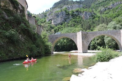
Le Pont de Ste-Enimie - © OTGCC nc  History
The bridge
Finally a bridge over the Tarn!
In the 13th century, the Benedictine monks of Sainte-Énimie built a bridge to replace the ford, or possibly a previous, more precarious construction. The new bridge linked Sainte-Énimie to the Causse Méjean plateau, where the Benedictine community owned land. Commerce and trade with Lower Languedoc (wool, woven products, wine) boomed. The village soon became an essential point on the important pilgrim route linking Le Puy-en-Velay with Aniane, via Saint-Guilhem le Désert. In the Middle Ages, it was rare to find so many bridges that could be crossed with carts and other large means of locomotion. The monks were true visionaries: today, the bridge is the only access to the Causse Méjean from the Tarn gorge that is authorised for buses and lorries weighing more than 19 tonnes (on the D986 linking Mende with Meyrueis).
Doline - © OTGCC nc HistoryWoods and deforestation
Afforestation and deforestation seem to be the fate of the Causse landscape. In the Neolithic, the first farmer-shepherds settled on the fertile areas of the plateaux, which were covered by beech and oak forest at the time. This lead to the forest being cleared for sheep pasture and for farmland. With demographic expansion, deforestation accelerated and the cultivated areas expanded. Subsequently, the local potteries, lime kilns and, later, mines brought about a new wave of deforestation to satisfy their need for wood.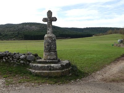
La croix du Buffre - nathalie.thomas HistoryLe Buffre cross
This is one of the oldest and most handsome crosses in Lozère. On its cylindrical pedestal (12th c.), which is set on three steps, two persons face each other on either side of a holy water basin representing a human face. The basin is carved into the pedestal and also projects from it. The more recent actual cross is believed to date from the 18th century. Le Buffre cross is one of many that dot the Saint Guilhem route, to both guide and encourage pilgrims.
L'église de Hures - nathalie.thomas  Architecture
The church of Hures
The church was founded in the 11th century by the Benedictine monks of Sainte-Enimie to expand their arable land. It was built in four stages:
- The choir in the early and the nave in the late 12th century,
- the right-hand chapel in the 14th century,
- the left-hand chapel in the 18th century.
Each enlargement of the building corresponded to an increase in the Causse population. The nave has a beautiful window. To the right of the entrance is a funereal recess, which probably belonged to a local dignitary and in which were deposited a number of bones removed from the buried body.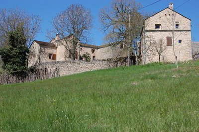
Vue sur Pauparelle - © Nathalie Thomas HistoryPauparelle
From Pauparelle, there is a nice view of the village of Ayres. This hamlet came into being in the 11th century around a Benedictine priory, founded by the Abbey Saint-Victor-de-Marseille on the current site of the castle. The latter, laid out in the 16th century on the ruins of the monastery, was pillaged and burned to the ground by the Camisards in 1703. Rebuilt in 1710, it is now a renowned hotel. Pauparelle is a private property that is not open to visits. Its name means “estate of the poor”. The farm buildings and living quarters date from the 17th and 19th centuries. Until 1850, the property belonged to the Charity Office of the town of Meyrueis, which, at that time, had about 5,000 inhabitants. (Jérôme Reversat)
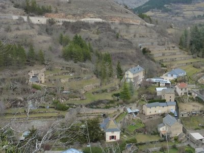
Terrasses sur Meyrueis - © Nathalie Thomas AgricultureTerrace
Throughout the climb, you will see abandoned former crop terraces. A few grapevines have persisted since local wine-growing came to an end. They bear witness to the fact that the slopes around these hamlets and villages were once cultivated and planted with fruit trees and vines. Terraces like these were the only way for the valley's inhabitants to have flat areas with deep soil suitable for growing.
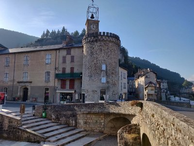
Le centre de Meyrueis et sa tour - Béatrice Galzin ArchitectureThe village of Meyrueis
The geographical location of Meyrueis is remarkable, nestled between the Aigoual massif, the causse Noir and the causse Méjean. Here the Camin Ferrat crosses the Jonte river. Pilgrims and transhumant flocks of sheep stopped in the village before continuing their journey. Many merchants came to its large fairs. Stroll through the lanes and relive the flourishing past of the belle époque. From the prosperous bourgeois residences to the marketplaces, everything still speaks of the past! Sheep’s wool from the plateaux was woven here, silk was spun. There was intense economic activity. In the 17th century, Meyrueis became a centre for hat-making. By 1860, 17 milliners were busy making hats for Languedoc and Provence, beautiful and exceptionally high-quality hats made from felted wool and silk bourette. Discontinued as of about 1920, this activity left room for tourism, which today animates the village.
L'arbre et la vie - Gaël Karczewski  Know-how
Forest management
The Mont Aigoual forest.
The wood harvested here comes from a forest that was reforested from the late 19th century onwards, after a period of overgrazing. This forest begins, grows and dies like all living beings. The job of foresters is to manage and support its development while respecting the laws of nature. They harvest trees before they die to make room for young trees. These tree trunks supply an entire economic sector, from the lumberjack to the skidder operator, the saw operator and the carpenter or cabinetmaker. Wood also accompanies you throughout your lives, from your cradle, furniture, woodwork and the wooden frame of your house to your coffin.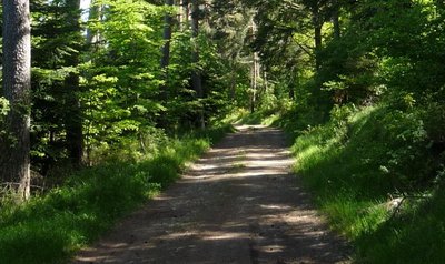
La piste en forêt - Michel Monnot HistoryThe Commanders
You are on a ridge path on the so-called “Commanders’ crests”. It is the last trace of the fact that this area belonged, from 1312 onwards, to the Knights Hospitaller and then to the Knights of Malta, who were based at the nearby hamlet of Servillières, at their “Commandery of Meyrueis and Servillières”. You are here on the border between the Gard and Lozère, marked by a standing stone. This ridge path is called the “wolf pen drovers’ road”, a variant thousands of years old of the main drovers’ road of La Lusette between L'Espérou and Meyrueis. Transhumant livestock would overnight here, in a closed-off space safe from wolves.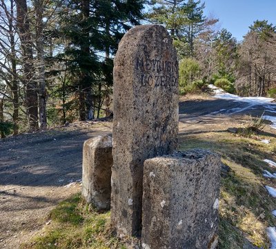
La Pierre Plantée - Béatrice Galzin HistoryPierre plantée (Pierre plantée)
Since ancient times, stones have stood along the Camin Ferrat: directional markers indicating a crossroads. Above all, they marked the boundaries of two parishes. Since the creation of Departments in 1790, they have outlined the border between Gard and Lozère.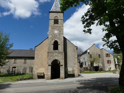
Camprieu - nathalie.thomas HistoryCamprieu
In the 19th century, the village streets were bustling year-round with a throng of artisans, labourers and shopkeepers, who lived in these modest mountain houses that were also suitable for livestock rearing. Camprieu had: two cobblers, six clog makers, two basket makers, one carpenter, two wheelwrights, two farriers, one miller, two stonemasons, one glassworks, one sawmill, one dairy, two grocer’s shops, a haberdashery and ironmonger’s and one shop for ladies’ “fashion and dresses”. There was also a cheese cellar that produced Roquefort until 1932, a hotel and an inn.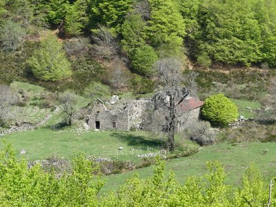
L'Abbaye de Notre-Dame-du-Bonheur - nathalie.thomas HistoryNotre-Dame-du Bonheur
This Romanesque monastery was built in the 11th and 12th centuries by the rich Lord of Roquefeuil and Mandagout, with the noble intention of turning it into a “hospital for the poor”. He allowed the monks to reap the fruits and revenue of the land. In return, the villagers paid him sheep, pigs, poultry, wine and cheese. He also charged the transhumant herds on his vast estate pasture fees. The path that passed through this peatbog linked Languedoc to the Gévaudan. A snowstorm bell weighing 200 kg would ring in fog or blizzards to help merchants, peddlers, itinerant workers, farmers etc. find their way to safety. The monastery had six canons, the last of whom was forced to leave during the French Revolution. An association dedicated to preserving the Abbey of Notre-Dame du Bonheur is working to restore it.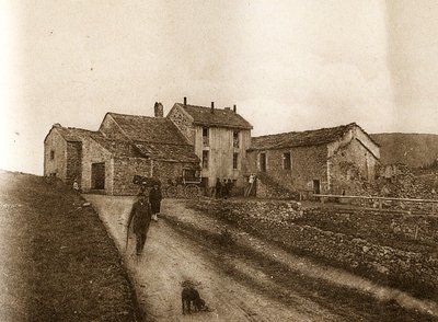
Maison forestière de la Serreyrède - © Jacques de Joly AgricultureLa Serreyrède
Before 1861, the house at the Col de la Serreyrède was inhabited by two families of farmers. They owned some livestock and had a vegetable garden, whose terraces you can still see above the La Caumette track. From 1861 on, the farm was inhabited by a forest ranger. It was only bought by the state body Eaux et Forêts in 1883, to be turned into a forester's house. It became one of Georges Fabre's headquarters during the reforestation of the Aigoual massif. The Cévennes National Park, tourism office and Terres d'Aigoual growers have now joined forces to revive La Serreyrède with the help of the Communauté de Communes Causses Aigoual Cévennes – Terres solidaires.
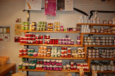
Boutique des producteurs - © Nathalie Thomas AgricultureThe association "Terres d'Aigoual"
The Cévennes National Park rents out part of the building to the association, enabling local farmers to sell their products directly to the public. The association brings together farmers who wish to promote what they produce and share their know-how. They also enjoy sharing their vision of farming- high quality produce and products,
- human-sized farms,
- mutual aid.
Come and discover their products!
 History
From beech copse to mature plantation
Marker 1
Around 1850, before reforestation began, the inhabitants of the Cevennes were using local wood resources on a massive scale for heating and in industry, especially spinning-mills. Gradually, only a few beech copses remained, which were cut every 25 to 40 years. Grazing by tens of thousands of sheep further reduced the herbaceous plant cover. Much weakened, the plant cover was then also subjected to heavy precipitation, the so-called Cevenol episodes. It is against this backdrop that the lengthy work of the foresters began. To reduce risks and establish a lasting forest cover, the first technique was to make use of what was already present by converting the disused copses into mature plantations.- Know-how
Productive forest
Marker 2
Another method of creating a durable forest cover is to plant or sow. This work is carried out either on bare soil or among existing tree stands. The Aigoual reforestation programme was a gigantic effort, requiring 900,000 days of work, the planting of 60 million conifers and 7 million deciduous trees, and sowing of 38 tonnes of seeds. Spruces and pines, which can be planted in full sunlight and grow quite quickly, were widely used. Under the forest canopy, preference was given to firs.  Natural environment
Irregular forest
This tree population consists of trees of very different diameters, ages and heights. Species are mixed: mainly pine, but also beech, rowan and whitebeam. This is an irregular mature forest, a forestry dynamic that is interesting for several reasons: it creates permanent forest cover; resistance to soil erosion; better resilience against storms or parasite attacks; regular production, etc. In the small clearing to the left of the path, the sunlight now penetrating to the forest floor has made natural regeneration of beech and fir possible, ensuring the renewal of the forest.
Le village d'Aulas - Nathalie Thomas HistoryThe village of Aulas
In the old days, the Place de l’Airette was where the wheat was thrashed. The village’s two fountains – on the Place de l'Airette and on the church square – were created on the initiative of the village council in 1887. They were almost removed when the houses were connected to mains water but were preserved by the support of certain councillors. Aulas was called Aulacio in 1001, from the Latin man’s name Aulas. In the 14th century, the village was fortified due to the many groups of brigands in the area. The ramparts were bordered by ditches and had gates. One of them, La Poterne, can still be seen. The village has remained picturesque thanks to its narrow lanes, its covered passage and its old buildings.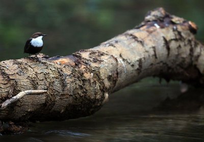
Cincle plongeur - Régis Descamps  Fauna
FaunaThe white-throated dipper
White-throated dippers are nesting in the bridge’s cavities. These birds look like they are in evening wear: white shirt and dark grey frock coat complete with an elegant tail, short and uplifted. They live in clean waterways with fairly strong currents. Perched on stones sticking out of the water, they inspect the riverbed agitatedly. Also called water ouzels, they can dive and then walk underwater while searching the riverbed for food. In one day, they can dive up to 1,600 times and stay underwater for a cumulative total of two hours.
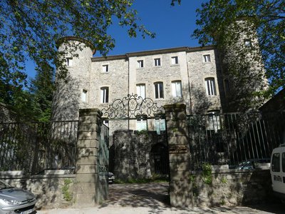
Château de Montcalm - Nathalie Thomas HistoryThe Château de Montcalm
The walls of the park surrounding the mediaeval Château de Montcalm border the road. The former fortress was remodelled several times. The fortifications and ramparts were pulled down in 1609. The residence was redesigned in the 18th century and an avenue of cedars planted in the park. In the late 19th century, the roofs bristled with crenellations. It was in the 1930s that the château assumed its current appearance.
Description
Only the section of this GR® [long-distance hiking path] which crosses the territory of the Cévennes National Park, from Ste-Enimie to Le Vigan, is described here.
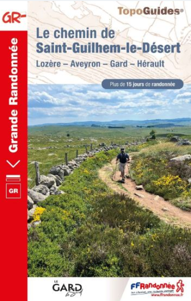
You can find the whole itinerary in the topographic guidebook Le Chemin de Saint-Guilhem-le-Désert (ref. 4834), published by the French hikers’ federation (FFRandonnée) and available for purchase in the Maisons du tourisme et du Parc [tourist office and National Park information centre] the online shop www.cevennes-parcnational.fr, bookshops, sports shops and at https://boutique.ffrandonnee.fr.
All information is also available on the website of the association “Les Amis du Chemin de Saint Guilhem”: http://www.chemin-st-guilhem.fr/accueil/
- Departure : Sainte-Enimie
- Arrival : Avèze
- Towns crossed : Gorges du Tarn Causses, Mas-Saint-Chély, Hures-la-Parade, Meyrueis, Lanuéjols, Saint-Sauveur-Camprieu, Val-d'Aigoual, Dourbies, Bréau-Mars, Arphy, Aulas, Le Vigan, and Avèze
Forecast
Altimetric profile
Recommandations
NB: For various reasons, the waymarked path may differ from that shown in the topographic guidebook: please follow the waymarks on the trail.
Make sure your equipment is appropriate for several days of hiking as well as the day’s weather conditions. Remember that the weather changes quickly in the mountains. Take enough water, wear sturdy shoes and put on a hat. Please close all gates and barriers after yourself.
Information desks
Tourism office Cévennes Gorges du Tarn, Sainte-Enimie
village, 48210 Sainte-Enimie
This office is part of the National Park's associated tourist-information network, whose mission is to provide information on, and raise awareness of, the sites and events as well as the rules that must be observed in the National Park's central zone.

Tourism & national parc'house
Col de la Serreyrède, 30570 Val d'Aigoual
The Maison de l'Aigoual houses the tourism office Mont Aigoual Causses Cévennes and the Maison du Parc national. This visitor centre provides information on and raises awareness of the Cévennes National Park, its sites and events as well as the rules that must be observed in the National Park's central zone.
On site: changing exhibitions, video projections, Festival Nature events and shop Open year-round

Tourism'house and national Parc at Florac
Place de l'ancienne gare, N106, 48400 Florac-trois-rivières
This office is part of the National Park's associated tourist-information network, whose mission is to provide information on, and raise awareness of, the sites and events as well as the rules that must be observed in the National Park's central zone.
On site: exhibitions, video projections, events and shop Open year-round

Tourism office Cévennes and Navacelles, Le Vigan
Maison de pays, place du Marché, BP 21, 30120 Le Vigan
This office is part of the National Park's associated tourist-information network, whose mission is to provide information on, and raise awareness of, the sites and events as well as the rules that must be observed in the National Park's central zone.
Open year-round
Calculateur d'itinéraire Lio
Utilisez le calculateur liO pour organiser votre trajet en région Occitanie.
Autres régions
Calculez votre itinéraire en Auvergne Rhône Alpes sur Oùra
Biodiversité autour de l'itinéraire
Source


Report a problem or an error
If you have found an error on this page or if you have noticed any problems during your hike, please report them to us here: