
The streams walk
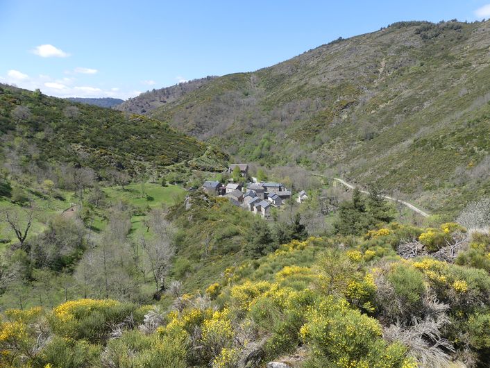
Under the canopy of majestic beeches, gaps in the vegetation will give you views onto the Béthuzon valley, the hamlet of Le Villaret and, in the distance, the Causse Méjean plateau.
3 points of interest
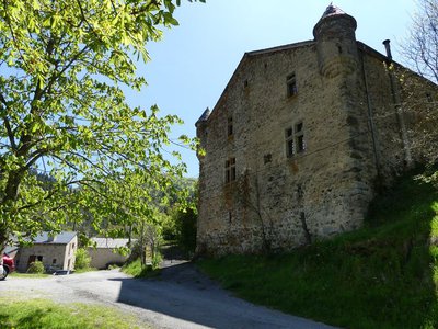
Château du Villaret - nathalie.thomas  History
Château of Le Villaret
This 16th-century château protects the hamlet of Le Villaret. Like all the land around, it belonged to the barons of Roquedols and was lived in by the youngest of the family. For several decades, it was the property of the writer and journalist Jean Lartéguy.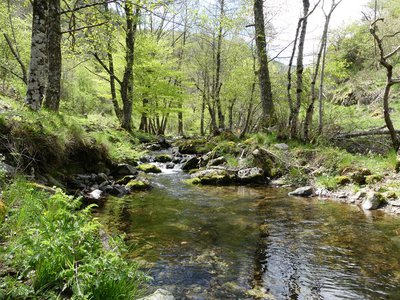
Ruisseau de la Croix de Fer - nathalie.thomas  Water
WaterFageole and Croix-de-Fer brooks
The Fageole is a tributary of the Croix-de-Fer. The latter flows into the Béthuzon at Le Villaret, which flows into the Jonte at Meyrueis, then the Tarn at Le Rozier and the Garonne at Moissac. These two brooks are at the head of the Atlantic drainage basin. They are home to (usually small) trout. Adult trout live in these environments that lack organic matter by feeding on the larvae of mayflies, whose larval stage is aquatic and lasts for several months.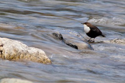
Le cincle plongeur - Gaël.Karczewski  Fauna
FaunaWhite-throated dipper (Cinclus cinclus)
You may have the opportunity of seeing a white-throated dipper here, a brown and white bird the size of a blackbird. It has a very particular hunting technique: it plunges suddenly, headfirst, using its wings to reach the riverbed. It prefers to move upriver. Its diet consists of small crustaceans, aquatic insects and leeches.
Description
Go through the village to get to the Croix-de-fer stream. Cross the stream.
- Cross it and go uphill for about 100 m towards a crossroads.
- Turn right and go through the village again. Walk alongside the stream, then follow its tributary, the Fageole. Cross it to continue climbing through the woodland to join a wide forest track.
- Turn left and continue for 1.5 kilometres.
- Then take a path going downhill on your left, which is suitable for motor vehicles for 500 m, then take a path on the left that overlooks the Croix-de-Fer stream and goes down to the village of Le Villaret. Cross the stream at the ford and go back up to the village of Le Villaret.
- Departure : Le Villaret (Meyrueis)
- Arrival : Le Villaret (Meyrueis)
- Towns crossed : Meyrueis
Forecast
Altimetric profile
Recommandations
Steep uphill section early on. Several fords (must be avoided during flooding).
Make sure your equipment is appropriate for the day’s weather conditions. Remember that the weather changes quickly in the mountains. Take enough water, wear sturdy shoes and put on a hat. Please close all gates and barriers behind you.
Information desks

Tourism'house and national Parc at Florac
Place de l'ancienne gare, N106, 48400 Florac-trois-rivières
This office is part of the National Park's associated tourist-information network, whose mission is to provide information on, and raise awareness of, the sites and events as well as the rules that must be observed in the National Park's central zone.
On site: exhibitions, video projections, events and shop Open year-round
Access and parking
From Meyrueis, D 986 towards Bout de Côte. 200 m after the roundabout, small road towards Roquedols, Ferrusac, Le Villaret.
Parking :
Calculateur d'itinéraire Lio
Utilisez le calculateur liO pour organiser votre trajet en région Occitanie.
Autres régions
Calculez votre itinéraire en Auvergne Rhône Alpes sur Oùra
Biodiversité autour de l'itinéraire
Source


Report a problem or an error
If you have found an error on this page or if you have noticed any problems during your hike, please report them to us here: