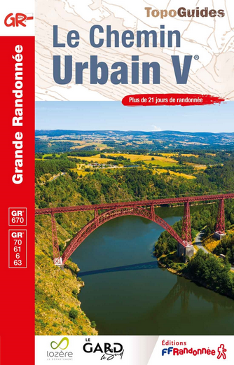
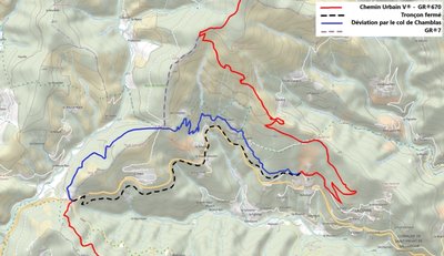
GR® 670, the Urban V trail
This trail showcases sites that are steeped in history, have remarkable natural and cultural heritage, and are charged with spirituality. The itinerary takes hikers from the Aubrac to the Popes’ Palace in Avignon, via the Tarn gorge, the Bougès massif, the northern Cévennes and the Gardon valleys, to discover an exceptional man!
28 points of interest
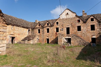
Ancienne ferme fortifiée de Chapieu - © Guy Grégoire  Architecture
Chapieu farm
"These buildings, which were the headquarters of a very large Causse farm, are laid out around a central courtyard. The main building faces south and consists of two floors of living quarters above a sheepfold. Two barns under vaulted granges that are 22 m long form the wings.” (A. Boemare)
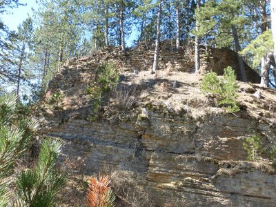
Château de Chapieu - © Nathalie Thomas  History
Château de Chapieu
"This château is the oldest in the Tournel barony. The Chapieu site is a diverticulum of the Causse de Mende, with steep slopes on three sides. To defend it, one simply had to bar the passage linking it to the plateau. It is likely that an oppidum preceded the castle from the Iron Age onwards. (…) Was it finally razed to the ground on Richelieu's orders, like so many others? In any case, it is nothing but ruins from the 17th century on.” (A. Boemare)
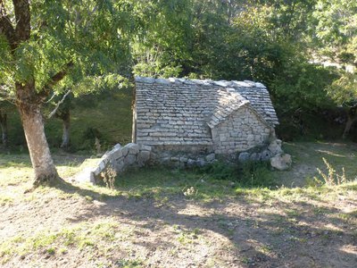
Le moulin de La Fage - Nathalie Thomas ArchitectureLa Fage
The hamlet of La Fage has a wealth of ancient architecture and exceptional rural heritage. You can admire:
- its former mill, below the road just before you enter the hamlet;
- the bread oven, with its work room;
- the stall for shoeing cattle;
- the wash house;
- its cross with stoup and granite slab, on which the coffin was placed during funerals;
- the blizzard bell tower, built while waiting for a church that never materialised. The bell formed the pattern of daily life, and on days of powder-snow blizzards, the villagers ran it to help travellers find their way safely to the village.
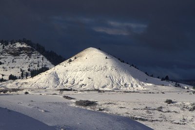
Puechs des Bondons sous la neige - © Jean-Pierre Malafosse  Geology
Puech d'Allègre and Puech de Mariette
Marker 2
These natural eccentricities with their generous proportions have reminded some of female forms. Were they at the origin of a fertility cult connected also with the menhirs and their phallic silhouettes? According to one legend, it was Gargantua who created the puechs by scraping dirt off his clogs. Geologically, the Cham des Bondons is part of the Causse de Sauveterre, to which it is connected by the Col de Montmirat pass. The limestone cham sits atop the granite bedrock of the Mont Lozère and offers remarkable landscapes, notably the Eschino d'Aze with its donkey's-back appearance, and the puechs, buttes of fossil-rich black marl.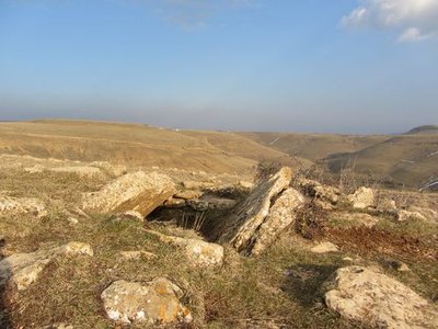
Dolmen des Combes - © Eddie Balaye  Archaeology
Dolmen at Les Combes
Marker 3
Of the megalithic monuments, dolmens (megalithic portal tombs) tend to be better-known than menhirs. They were linked to funeral practices from 3500 BC (end of the Neolithic) to 200 BC. The dead were deposited in these collective tombs alongside personal objects. Funeral practices offer precious clues for understanding the beliefs and organisation of ancient societies. These monuments are often located in spots that dominate the surroundings, and would certainly have reminded the living of the dead.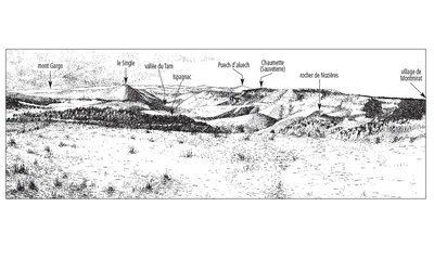
L'horizon des causses - © Olivier Prohin  Landscape
Panoramic viewpoint
Marker 4
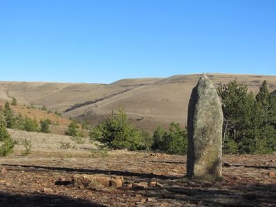
Menhirs de Chabusse - © Eddie Balaye ArchaeologyChabusse
Marker 5
The Chabusse berm, which cuts abruptly across the slope, has three handsome menhirs and a fourth modest and incomplete one, and also bears other traces of successive settlement. Dr Charles Morel, who published the first menhir inventory of the Cham des Bondons, reported that a large axe made out of polished granite was found here. This, in addition to other objects found more recently (shaped flints, arrowheads, scrapers, etc.), shows that the area was inhabited at the time of the menhirs. On the same site, excavations of two tumuli uncovered human remains from multiple burials and/or bone burials, along with objects dating from the Bronze Age to the beginning of the Roman occupation.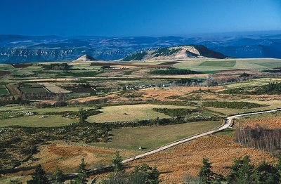
Les Puechs des Bondons vus du Rocher des Laubies - © Jean-Pierre Malafosse GeologyMines and menhirs
Marker 6
The region is scattered with geological faults, which are responsible for the presence of ores. Locally there is predominantly barite, but also zinc and silver-bearing lead. Scientific analyses carried out in local peat bogs demonstrate that lead was being mined 2,500 years ago and again a thousand years later. Recently a uranium deposit was mined in the municipality of Les Bondons. The fact that menhirs stand just above the seam has led some people to associate megalithism with the hypothesis of magnetism, though there is no scientific proof for this. Recent research has shown that the choice of location for menhirs is mainly linked to the way territory was organised at the end of the Neolithic.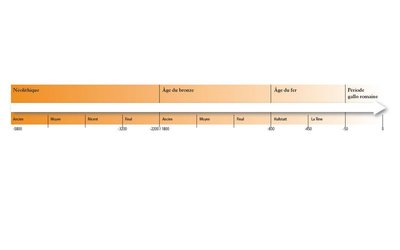
Chronologie de la Préhistoire - © Olivier Prohin HistoryLes Combettes
Marker 7
The village of Les Combettes is built in a natural depression, as its name indicates (combette = little valley). The exhibition on display in the communal oven building emphasises how late Mont Lozère was first settled. By the Upper Neolithic (around 3500 BC), the region of the Grands Causses was widely settled, following a population increase. The first agro-pastoral communities formed, creating farms and villages and clearing land to grow cereals and breed livestock, whilst still hunting and gathering. These groups are behind local megalithism. The age of metals put an end to the practice of erecting menhirs, but dolmens were in use for a while longer.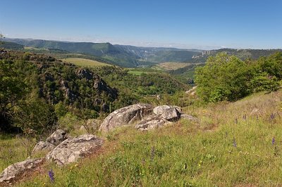
Gorges depuis la combe des Cades - © Guy Grégoire LandscapeConstructing landscapes
Marker 8
Did the menhir-builders move in the same landscape that we see today? Current archaeological knowledge does not allow us to reproduce with great accuracy what the landscape of Mont Lozère’s slopes would have looked like in the late Neolithic. Yet the birth of agriculture and livestock rearing in the Neolithic without doubt opened a new chapter in the relationship between humans and nature. For the first time in their history, populations designed the landscape by dotting it with monuments, but more importantly by developing agricultural and pastoral activities. Today – 5,000 years later – human interventions are carried out based on Natura 2000 measures, which focus notably on keeping open spaces intact and maintaining agro-pastoral activities.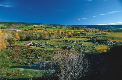
Le Bramont en aval des Faux - © jean Pierre Malafosse  Water
WaterThe river Bramont
There are actually two Bramonts! The one that you are cycling along, and another Bramont, which flows north of the Cham des Bondons. As you go through Les Combettes, you are at the foot of this limestone plateau, whose highest point is at about 1,200 m. But under the plateau flows another river: the underground Bramont, discovered in 1967. It takes some of the water of the Bramont du Lot (north) and empties it into the Bramont du Tarn (south)! The old-timers knew this and understood that by blocking, unblocking or diverting the waters draining out of the northern river, they could vary the rate of flow of the resurgence.
 Architecture
Pradines mill
This is one of the eight watermills that used to operate in the Ispagnac valley. Two were on the Tarn, the others on its tributaries. These mills produced wheat flour and chestnut flour as well as oil.
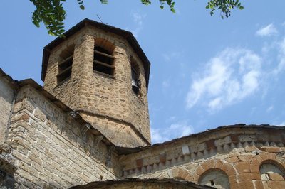
Chevet de l'église d'Ispagnac - cevennes-gorges-du-tarn ArchitectureIspagnac church
St-Peter’s Church in Ispagnac is one of the finest examples of Romanesque architecture in Gévaudan. Built in the 12th century, it is dedicated to Saint Peter and Saint Paul. The understated facade of this bulky-looking building has a simple gate with three semi-circular arches topped by a rose window that lets light into the nave. Once inside, you discover a simple and airy architecture. A sound-and-light show helps you to explore. To get the fullest impression of the architecture, you need to leave the building and walk around it to see the apse and its décor.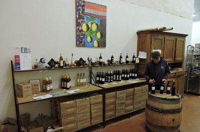
La cave viticole d'Ispagnac - cevennes-gorges-du-tarn AgricultureThe vintners of Ispagnac
In 2003, Sylvain Gachet, from Savoy, reintroduced grapevines to Ispagnac and Florac, planting six hectares of terraced land. On soils of clay/limestone and schist, he attempted to breathe new life into the Domaine de Gabalie. In 2006, Elisabeth Boyé and Bertrand Servières set up as vintners in the Tarn gorge, also under the stimulus package bringing vineyards back to the valley. They cleared the land of the bartas (brambles) which had invaded almost all the parcels, and rebuilt the dry-stone walls before planting almond trees, vine peaches and five hectares of grapevines: the Domaine des Cabridelles was born. The winemakers share a cooperative cellar in Ispagnac, which is also a sales outlet. Why not make a short stop to try the wines (the cellar is next to the car park by the state school (école publique).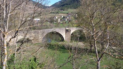
Pont de Quézac - © CC Florac Sud Lozère ArchitectureQuézac Bridge
This bridge crossing the river Tarn gives access to the village of Quézac, located on the left bank. Around 1350, Pope Urban V decided to fund its construction to facilitate pilgrims' access to the collegiate church of Notre-Dame de Quézac. It was finished in the 15th century. Its history is punctuated by partial destruction in floods, and by more or less solid rebuilding. It became a listed monument on 27 August 1931.
Source de Quézac - © Nathalie Thomas WaterQuézac mineral water
Quézac mineral water emerges naturally from the Diva spring, near the entrance to the village, in exceptional surroundings which have been naturally protected for centuries. This pleasant-tasting water is rich in mineral salts and trace elements and is also well-known to be beneficial for the stomach. The spring's water actually comes from Mont Aigoual. According to scientific studies, it takes 30 to 40 years for it to re-emerge in Quézac, after first settling in aquifers, where it acquires its effervescence naturally (rare in France).
- Geology
The iron-rich water of Salce
After a small detour from the hamlet of
Salièges to the river Tarn, you will come across a spring of ferruginous water. For a long time, the ability to prevent (or cure) alcoholism was attributed to this water rich in Fe2+ ions, and made famous by a sketch by the stand-up comedian Bourvil. It supposedly supplies the iron that would normally come from regularly drinking alcohol. A small construction indicates the Salce spring (the path from Salièges is way-marked), as does the red tinting from iron oxide, which you find in many contact zones between schist and limestone. 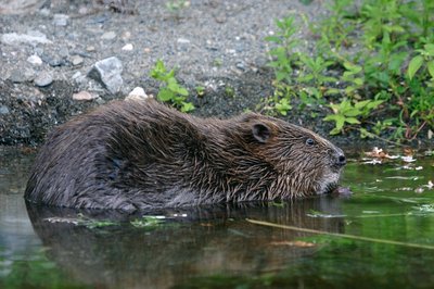
Castor au réfectoire - © Bruno Descaves  Fauna
FaunaThe European beaver (Castor fiber)
The calm deep stretches of the Tarn are good areas to settle for the European beaver, which lives in a lodge dug into the river bank. An essentially vegetarian animal, it bases its diet on cellulose. It eats young shoots, bark, aquatic plants, and foliage that is abundant in the riparian forest. It is thus useful in regulating the woody vegetation of river banks, facilitating the development of riverside fauna and flora. Through its activities, it prevents the potentially dangerous accumulation of dead wood during floods. It does not build dams.
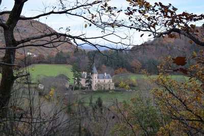
Château d'Arigès - © com com Florac Sud Lozère HistoryChâteau d’Arigès
This can be seen on your left, in a gap in the forest. It was only a share-cropping farm, whose buildings were in ruins, when the Lord of Issenges bought it in 1658. He lived in it from 1688. This Château, which is no doubt more comfortable than the « maison carrée » (“square house”), was built in a river bend of the Tarn and is surrounded by fertile soils well-suited for crop-growing.
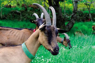
Chèvre de race alpine - © Olivier Prohin AgricultureThe Gautier goat farm
Yolande and Christian run a small farm where they make farmhouse goat's cheese, a typically Cévenol product. Their herd consists of 60 Alpine dairy goats, and all their milk is processed on-site into farmhouse cheese. From late November to late April, the nanny goats have a break so their little ones can feed!
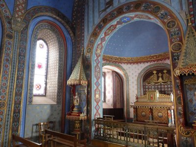
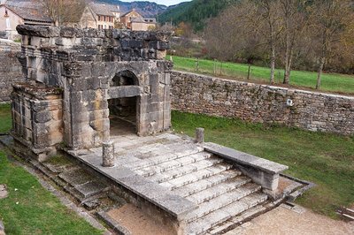
Chapelle St-Saturnin - © Nathalie Thomas HistorySaint-Saturnin chapel
Saint-Saturnin chapel stands at the heart of the village, surrounded by its cemetery. Inside every wall boasts a magnificent painted décor. It was built in the 12th century. Guillaume de Grimoard (the future Pope Urban V) was baptised here in 1309. It is next to the town hall (mairie) and is well worth a detour.
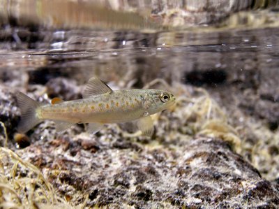
Truite fario - © Philippe Baffie FaunaThe brown trout (Salmo trutta fario)
This trout lives in our waterways and is an indigenous species. This stock is a part of our heritage. Its size varies with the quality of the water, fishing pressures, and the nature of the riverbed (hiding-places). In the summer, it hunts in white water and on the surface, and catches insects. In the winter, it eats larvae on the bottom. Reproduction begins in November and is staggered throughout the winter. The female lays its eggs on a gravelly stretch of the riverbed, into which it has dug a pit using its caudal fin. The male deposits its milt over the eggs. Once they are fertilised, the eggs are covered with gravel. Reproductive success depends on variations in the water flow and especially on the risk of the spawning areas drying out in dry winters.
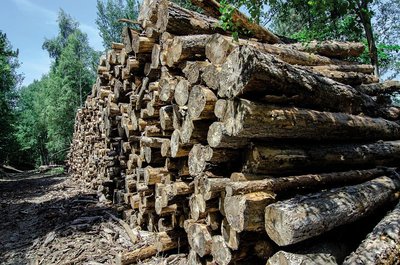
coupe de bois - © Olivier Prohin  Know-how
Fages Sawmill
Upstream from Bédouès, you will see a sawmill, which mainly produces wood to make crates and pallets. It also produces some timber. Today, local forestry companies utilise wood in a number of ways: for energy, paper pulp, timber, crate-making and construction.
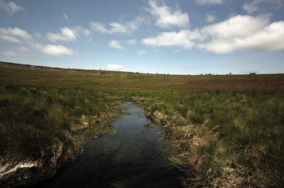
Source du Tarn - © Yannick Manche WaterThe river Tarn
The Tarn has its spring at an altitude of 1,550 m under the ridge of Mont Lozère. Having carved its way into the granite bedrock, it separates the Bougès massif from Mont Lozère. After Bédouès, it meets the river Tarnon and slowly enters the limestone region, in which its bed is increasingly deep. At its confluence with the Jonte, at Le Rozier, the Tarn leaves the department of the Lozère.
 Natural environment
Scots Pine forest (Pinus sylvestris)
Marker 5
The Scots pine is a typical example of a dynamic, sun-seeking species that colonises soils impoverished by centuries of grazing. Its winged and light seeds can be carried over several hundred metres by the wind, thus enabling it to spread rather quickly. Here we are in a young pine forest that is winning the battle against callune (heather). Its pale foliage lets light penetrate to the undergrowth and enables other species (oak, beech or fir) to grow. They will eventually dominate the pines by depriving them of light.
Les Ayres - nathalie.thomas HistoryLes Ayres
Through the ages, the location of Les Ayres on the draille (drovers’ road) brought merchants, mule drivers and shepherds and made the hamlet a well-known spot for loues (hiring fairs), where day labourers – shepherds, horsemen, threshers – came to find work.
"There were three loues, the first on the Sunday after 29 September, on Saint-Michael’s, the big fair a week later and the third the following week (....)"
Labourers hired themselves out for various jobs: silkworm or chestnut harvesting, threshing wheat or picking grapes, guarding and accompanying sheep flocks on the summer pastures… There was no work contract when employer and employee reached agreement. The day labourer left a personal belonging with his employee as a security.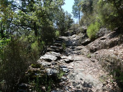
Vieux chemin - nathalie.thomas HistoryNature tamed
On this path, you see the determination of the inhabitants of the Cévennes to tame the rebellious environment: here, an arch bridge crosses a river whose water has carved a steep-sided valley, creating “cauldrons”; there, one whole side of the path has been dug out of the rock to cross from one slope to the other; further on, bancels (low walls) have been built to hold back the soil in which the chestnut trees were planted. Locals even rerouted the water to irrigate their crops and protect themselves from the run-off of powerful rains. This is a well organised environment: the water collected at the spring is stored in basins before being redistributed via a network of béals (irrigation channels). The vegetable plots are on terraces closest to the house. A little further away are the irrigated fields, fruit trees, mulberry trees and beehives. The chestnut orchard surrounds the crop land. On the terraces, gutters known as trincats allow water to run off. Stone thresholds have been built across the rivers to regulate the flow and to regulate any soil washed away by the water.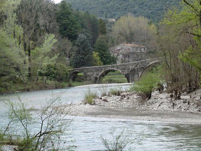
Le pont des Camisards - nathalie.thomas HistoryThe Pont des Camisards
Legend has it that this humpback bridge was built from 1702 to 1704 by Jean Cavalier, a leader of the Protestant Camisard uprising against the Catholic King. And a legend is all it is. It was constructed a decade later, from 1714 to 1718, when Louis XIV's Intendant, a Monsieur de Basville, decided to develop the road network in the Cevennes. The diocese of Alès was responsible for funding a large share of the construction, and the inhabitants of Mialet were forced to participate through work our paying taxes. In 1976, it became a listed monument. (Nelly Bernard)
Description
Only the section of this GR® [long-distance hiking path] which crosses the territory of the Cévennes National Park, between Mende and Anduze, is described here.
You can find the whole itinerary in the topographic guidebook Le Chemin Urbain V (ref. 670), published by the French hikers’ federation (Fédération française de randonnée pédestre) and available for purchase in the Maisons du tourisme et du Parc [joint tourist office and National Park information centre], the online shop at www.cevennes-parcnational.fr, bookshops, sports shops and at https://boutique.ffrandonnee.fr.
The association Les Amis du Bienheureux Pape Urbain V can assist you and give you all the necessary information for a successful hike: www.randonnee-urbain-v.com
- Departure : Mende
- Arrival : Anduze
- Towns crossed : Mende, Saint-Bauzile, Lanuéjols, Saint-Étienne-du-Valdonnez, Les Bondons, Ispagnac, Gorges du Tarn Causses, Florac Trois Rivières, Bédouès-Cocurès, Pont de Montvert - Sud Mont Lozère, Cassagnas, Saint-André-de-Lancize, Saint-Privat-de-Vallongue, Saint-Hilaire-de-Lavit, Saint-Germain-de-Calberte, Saint-Étienne-Vallée-Française, Saint-Jean-du-Gard, Mialet, Générargues, and Anduze
Forecast
Altimetric profile
Recommandations
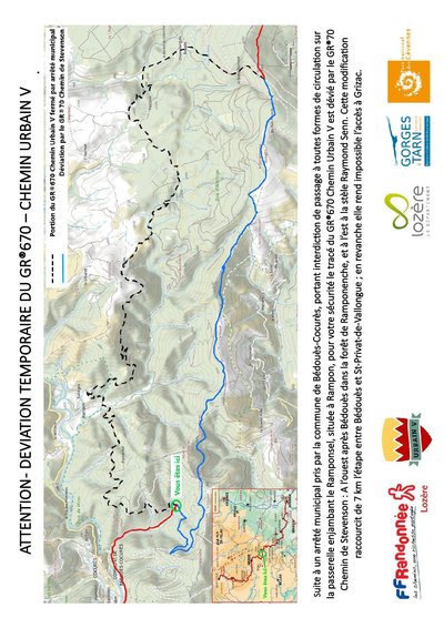
NB: For various reasons, the waymarked path may differ from that shown in the topographic guidebook: please follow the waymarks on the trail. Make sure your equipment is appropriate for several days of hiking as well as the day’s weather conditions. Remember that the weather changes quickly in the mountains. Take enough water, wear sturdy shoes and put on a hat. Please close all gates and barriers behind you.
Information desks

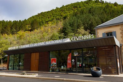
Tourism'house and national Parc at Florac
Place de l'ancienne gare, N106, 48400 Florac-trois-rivières
This office is part of the National Park's associated tourist-information network, whose mission is to provide information on, and raise awareness of, the sites and events as well as the rules that must be observed in the National Park's central zone.
On site: exhibitions, video projections, events and shop Open year-round

Tourism office Coeur de Lozère, Mende
BP 83, place du Foirail, 48000 Mende
This office is part of the National Park's associated tourist-information network, whose mission is to provide information on, and raise awareness of, the sites and events as well as the rules that must be observed in the National Park's central zone.
Open year-round

Office de tourisme Des Cévennes au mont Lozère
le Quai, 48220 Le Pont de Montvert sud mont-Lozère
Transport
Bus line 251 Mende - Florac
Bus line 252 Florac - Alès
Bus line 112 Saint Jean du Gard - Anduze
https://lio.laregion.fr/
Calculateur d'itinéraire Lio
Utilisez le calculateur liO pour organiser votre trajet en région Occitanie.
Autres régions
Calculez votre itinéraire en Auvergne Rhône Alpes sur Oùra
Biodiversité autour de l'itinéraire
Source


Report a problem or an error
If you have found an error on this page or if you have noticed any problems during your hike, please report them to us here: