
Aire-de-Côte
4 points of interest
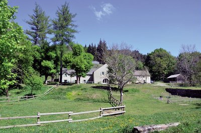
Aire de Côte - Stephan.Corporan  History
Aire de Côte
Aire-de-Côte farm was purchased by the French State in 1862, during the period of reforestation. Before the farm became a stopover gîte, it was for a long time the residence of the local forester and his family. In the first half of the 20th century, Aire-de-Côte was very different. To the north, behind the house, was the draille (drovers’ road), lined by upright stones and 40 to 50 metres wide. Thousands of transhumant animals passed every year on their way to or from summer pastures. The transhumant animals stopped there at lunchtime, then continued on towards Mont Aigoual.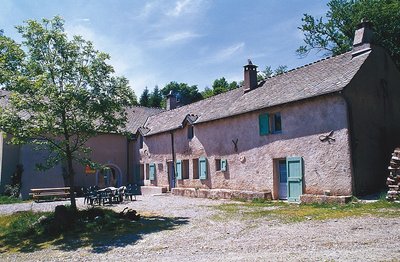
Guy.Grégoire HistoryA Resistance refuge
In early 1943, the first Resistance group of the Cévennes was formed. The refuge of the Aire-de-côte group was one of the wooden shacks used for forestry works, whose roof was camouflaged using branches. On 10 July 1943, a message warned the post office in Rousses that a German attack was imminent. The Resistance was informed – but a storm delayed the group’s departure. The Germans arrived… The forester was arrested as an accomplice, accused of being in radio contact with London. Indeed, the Aire-de-côte Resistance listened to a crystal radio set built by the two Jews who were hiding there.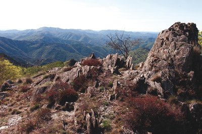
Vue depuis les 4000 marches - Olivier.Prohin  Water
WaterLe Coulet
At Le Coulet (meaning little pass), views open up onto the Mediterranean side, towards Valleraugue. The viewpoint lies on the watershed. Up to this point, the route followed the valley of the Bédil, a brook with a gentle, non-torrential gradient, whose waters flow into the Atlantic. Here, you discover the valley of the Clarou (a tributary of the Hérault), with its typically Mediterranean, i.e. more abrupt, profile. To the south, schist outcrops break through the slopes; to the north, the slopes are entirely wooded.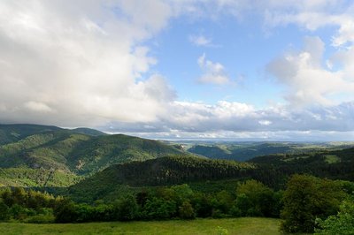
Vue sur la forêt de l'Aigoual - Arnaud.Bouissou  Flora
FloraReforestation
In 1875, the French State initiated a reforestation policy. It bought up existing beech forests and bare parcels. This was the case of Aire-de-Côte and the land belonging to it. To settle poor soils, foresters planted a pioneering species: the dwarf mountain or bog pine. On more fertile soils, nobler species were planted: fir, spruce and larch. Commercial exploitation began in 1938, when the local mines bought the first harvests to shore up mine tunnels. The original reforested areas were thinned out and firs planted beneath the pines. It is said that in a bedroom at Aire-de-Côte, there was a heap of coniferous tree seeds at least one metre high. They were sown onto the snow, which dragged them into the soil as it melted.
Description
Starting at the Aire de Côte gîte, head towards "Mont Aigoual" via "Montée du Bédil" and "Le Coulet", then follow "Col de l'Estrade" via "Valat du Bédil" to "Côte 1100". Return to "Aire de Côte" via "Montée du Bédil".
This walk is taken from the guidebook Massif de l’Aigoual, published by the Communauté de communes Causses Aigoual Cévennes as part of the collection Espaces Naturels Gardois and the label Gard Pleine Nature.
- Departure : Aire-de-Côte (Bassurels)
- Arrival : Aire-de-Côte (Bassurels)
- Towns crossed : Bassurels
Forecast
Altimetric profile
Recommandations
Information desks

Tourism & national parc'house
Col de la Serreyrède, 30570 Val d'Aigoual
The Maison de l'Aigoual houses the tourism office Mont Aigoual Causses Cévennes and the Maison du Parc national. This visitor centre provides information on and raises awareness of the Cévennes National Park, its sites and events as well as the rules that must be observed in the National Park's central zone.
On site: changing exhibitions, video projections, Festival Nature events and shop Open year-round

Office de tourisme Des Cévennes au mont Lozère
le Quai, 48220 Le Pont de Montvert sud mont-Lozère
Access and parking
Parking :
Calculateur d'itinéraire Lio
Utilisez le calculateur liO pour organiser votre trajet en région Occitanie.
Autres régions
Calculez votre itinéraire en Auvergne Rhône Alpes sur Oùra
Biodiversité autour de l'itinéraire
Source


Report a problem or an error
If you have found an error on this page or if you have noticed any problems during your hike, please report them to us here: