
Biasses
11 points of interest
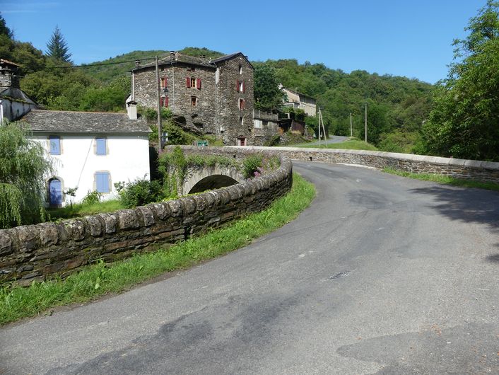
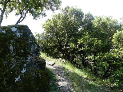
Vallée Française, temple de Molezon et tour de Biasses - © Sandrine Forge  Landscape
The scenery
From this vantage point you can discover the uppermost part of the Vallée Française, notably the temple (Protestant church) at Molezon and the tower of Biasses on the valley floor. In the west, the horizon is foreshortened by a limestone plateau: the Can de l’Hospitalet. This represents one of the furthest reaches of the ocean in the Mesozoic period, when it largely covered the old schist massif of the Cévennes.
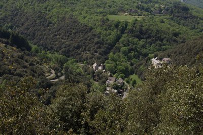
Paysage des Cévennes - © Guy Grégoire  History
The Vallée Française
The Vallée Française, originally known as the Val Francesque, is the middle valley in a system of three parallel Cévenol valleys (incl. Vallée Longue to the north-east and Vallée Borgne to the south). Legend has it that under the command of Roland, one of Charlemagne’s valiant knights, the valley fought off the Saracen invasion and remained Frankish. Other hypotheses refer to a valley that was franche, meaning exempt from certain taxes. However, it is more likely that the Vallée Française was a Frankish foothold in Visigoth southern France (5th and 6th centuries) during the times of division that followed the fall of the Roman Empire under the pressure of the so-called “Barbarian” tribes.
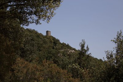
Tour du Canourgue - © Sandrine Forge HistoryA glimpse of the Tour du Canourgue
Architectural deterioration caused by the wear and tear of time as much as by removal of stones almost vanquished this impressive monument, which has stood for centuries at the point of a rocky promontory. The conservation efforts of several Cévennes-loving volunteers kept the tower standing in the 1960s, but without saving it for good. The Cévennes National Park bought it in 1990 with the aim of turning it into one of the components of the Cévenne Eco-Museum, and fully restored it the following year. The holm oaks growing near this point partially hide a set of terraces that bear witness to farming in days gone by.
Montée dans les chênes verts - nathalie.thomas  Flora
FloraHolm oak or chestnut
As you walk uphill towards Le Canourgue Tower, you will see the distinct asymmetry between the two slopes and its effect on vegetation and farming. On the south-west slope, which is drier, rocky and steep, holm oak dominates. On the other side of the valley, the exposure to the north-east (and therefore lower temperatures) and the gentler gradient are accompanied by deeper soils, which favours chestnut trees. History
Dating the site
The oldest records mentioning the Château du Canourgue date from 1219, but it is probably older. Throughout the 13th century, it was a fief of Raymond d’Anduze, then of Raymond de Barre. It then became a joint property of the King of France and the Bishop of Mende. Archaeological excavations have not been able to pinpoint exactly when it was built, but do show that it was abandoned in the late 14th or early 15th century, based on fragments of kitchenware discovered here (jugs and cooking pots from St-Quentin-la-Poterie, near Uzès). Architecture
An oven
At the valley-end of the staircase was a partially overhanging building. On the ground, at a hollowed-out spot, is a sandstone millstone wedged into place on its base by small upright schist slabs. It was probably re-used as an oven floor, but research has not shown what kind of oven – for bread or other purposes.
- Architecture
Defending and asserting one's authority
There was a square building here that controlled access to the tower. Between the staircase and the entrance into the tower, staggered walls and a narrow corridor intersected by doors reinforced the keep’s defences. Its defensive capacity should not be over-estimated. Ten or so armed people could surely capture it. Though it was a fortification, above all it enabled the lords who owned it to project their authority symbolically. But this was also a residence of local seigneurs. Although there is no precise information about the Tour du Canourgue, by comparison with similar buildings one can estimate that 20 to 30 people lived in it.
- History
Income from land and redevances
The lords of Le Canourgue had to live on the income from their lands, meaning the rents paid, especially in kind, by the peasants who farmed the estate's lands: sweet chestnuts or rye (grown underneath the chestnut trees), nuts and fruit (walnuts, plums, etc.), wine (not much) and meat products (essentially pork). Once a year, on a fixed date, the peasants living in the valley’s various mas or farms came to bring the rent they owed. Some farmed the terraced crop land near the castle and lived (among other professions) in the village built at its feet.
- History
The signal-tower hypothesis
The Tour du Canourgue is sometimes described as a “signal tower” similar to the towers near the coast, which allowed locals to watch out for the “Barbary corsairs”, and to communicate using fire. Such a system would have required joint organisation and solidarity between the local lords. This was not exactly the most common scenario in the Cévennes from the 11th to the 14th centuries, when alliances, counter-alliances and conflicts followed one another. The Tour du Canourgue may have been used for sending signals – though no records have so far been found to support this theory – but that was patently not its primary function.
- Architecture
The tower's architecture
On the facade, besides arrow-slits and one window, are two times two holes. This was probably where a wooden gallery (hoarding) was built on corbels to overhang the access.
Inside, on the first floor, the dimensions of the openings suggest that this was a living space despite its small size. On the top floor, the edge of the vault is embellished with a decorative cornice, an exact replica of the one in the keep at Garde-Guérin (north of Villefort). The double-sloped roof is the most common type for this kind of building. In the late 19th century (Romanticism), it was fashionable to add terraces and battlements when restoring towers. 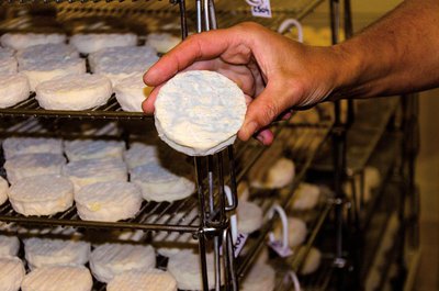
Pélardon - Olivier.Prohin AgricultureGoat farming
As an animal well adapted to being reared in the mountains, the goat has been in the Cévennes for a long time. Every family owned a few of these animals to have their own milk and cheese for its own consumption. The transformation from subsistence agriculture to market agriculture gave a new dimension to this livsestock farming, with the goats’ milk being turned into pélardon cheese. The Coopérative de Moissac-Vallée-Française, established in 1959, collects about one million litres of milk per year in the Cévennes (Lozère and Gard). Pélardon obtained the AOC label (controlled designation of origin) in 2000.
Description
Departure from Biasses bridge.
1) Take on your right the concrete path, pass the “Barral” house, continue on the path that comes out near the hamlet of Bruguier-Bas, reach the D983, and cross it to take the path opposite that goes to the hamlet of Les Plantiers (under La Canourgue tower).
2) At the hamlet of Les Plantiers, first take the left then take the right the path that climbs to La Canourgue tower.
3) From the tower, retrace your steps to take the path on the right.
4) Pass below the house of Le Bruguier-Haut and join up with the road that you follow to Mazel Escassier. Just after the house, take the path on the right that leads to the D983. Turn right onto the road for 100 m. Take the road on the left for 540 m.
5) Take the path on the right towards the Magnanerie de La Roque.
6) Below the magnanerie, take the path on the left that descends to the hamlet of Le Castelet. Continue in the chestnut orchard to the valley floor. Join up with the road and turn right onto it to Biasses.
- Departure : At Biasses bridge
- Arrival : At Biasses bridge
- Towns crossed : Molezon
Forecast
Altimetric profile
Recommandations
Make sure your equipment is appropriate for the day’s weather conditions. Remember that the weather changes quickly in the mountains. Take enough water, wear sturdy shoes and put on a hat. Please close all gates and barriers behind you.
Information desks

Tourism'house and national Parc at Florac
Place de l'ancienne gare, N106, 48400 Florac-trois-rivières
This office is part of the National Park's associated tourist-information network, whose mission is to provide information on, and raise awareness of, the sites and events as well as the rules that must be observed in the National Park's central zone.
On site: exhibitions, video projections, events and shop Open year-round

Office de tourisme Des Cévennes au mont Lozère
le Quai, 48220 Le Pont de Montvert sud mont-Lozère

Tourism office Des Cévennes au mont-Lozère, Sainte-Croix-Vallée-Française
Mairie, 48110 Sainte-Croix-Vallée-Française
This office is part of the National Park's associated tourist-information network, whose mission is to provide information on, and raise awareness of, the sites and events as well as the rules that must be observed in the National Park's central zone. :
Open year-round
Access and parking
From Barre-des-Cévennes, take the D983 towards Ste-Croix-Vallée-Française. Take the D 61 on your right towards Molezon - Le Pompidou to reach Biasses.
Parking :
Calculateur d'itinéraire Lio
Utilisez le calculateur liO pour organiser votre trajet en région Occitanie.
Autres régions
Calculez votre itinéraire en Auvergne Rhône Alpes sur Oùra
Biodiversité autour de l'itinéraire
Source


Report a problem or an error
If you have found an error on this page or if you have noticed any problems during your hike, please report them to us here: