
From one Gardon to the next
2 points of interest
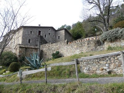
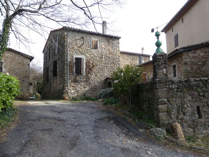
Arbousse - nathalie.thomas  History
The hamlet of Arbousse
When Tonin moved to Mas d'Arbousse in 1912, the road up from Saint-Jean-du-Gard was only a path. Without a single break, he carried his heavy cherrywood wardrobe on his back – having first removed the doors and shelves. On arrival in the hamlet, he quenched his thirst and then went back down for the rest of his piece of furniture. Thanks to the money he made by raising silkworms, Tonin paid off the purchase of his mas ((isolated farm) in only four seasons! In 1968 the hamlet of Arbousse only had three inhabitants compared to the forty-five it has today – the same number as in the 19th century.
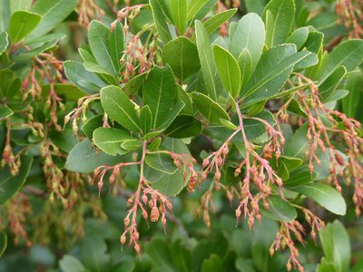
L'arbousier - nathalie.thomas  Flora
FloraThe strawberry tree
The strawberry tree, which has finely serrated evergreen leaves, brightens up the autumn not only with its white bell-like flowers but also with its orange-red fruit. For Pliny the Elder, the strawberry tree was related to the strawberry because of the shape of its fruit, a little prickly ball, and its colour. Yet the Latin origin of its name arbutus unedo is supposedly the contraction of unum edo: “I only ate one”. However, ripe tree strawberries, while stodgy, are quite soft and do not taste bad. Nowadays, they tend to be eaten mostly as jelly.
Description
Signposts will guide you all along this route. In the description below, the signposted place names and/or directions are given in bold italics between quotation marks :
- Starting at “Saint-Jean-du-Gard - Office du Tourisme”, walk to “Pic d’Arbousse” via:
- “St Jean - Musée”,
- “Arbousse” and
- “Les Théronds”. Then go to
- “La Teule”. From here, do a detour (there-and-back) to “Pic d’Arbousse“ (walk down to the viewpoint below the peak). From “La Teule”, return to “Saint Jean du Gard” via “Arbousse” (3) and “St Jean - Musée” (2).
This hike is taken from the guidebook Cévennes et vallées du Gardon, autour d’Anduze et Saint-Jean-du-Gard, published by the Agglomération d’Alès as part of the collection Espaces Naturels Gardois and the label Gard Pleine Nature.
- Departure : Saint-Jean-du-Gard (Post Office)
- Arrival : Saint-Jean-du-Gard (Post Office)
- Towns crossed : Saint-Jean-du-Gard and Saint-Étienne-Vallée-Française
Forecast
Altimetric profile
Recommandations
Make sure your equipment is appropriate for the day’s weather conditions. Remember that the weather changes quickly in the mountains. Take enough water.
Information desks
Tourism office Cévennes Tourisme, Anduze
Plan de Brie, 30140 Anduze
This office is part of the National Park's associated tourist-information network, whose mission is to provide information on, and raise awareness of, the sites and events as well as the rules that must be observed in the National Park's central zone. :
Open year-round

Tourism office Cévennes Tourisme, Saint-Jean-du-Gard
Maison rouge, 30270 Saint-Jean-du-Gard
This office is part of the National Park's associated tourist-information network, whose mission is to provide information on, and raise awareness of, the sites and events as well as the rules that must be observed in the National Park's central zone.
Open year-round
Transport
LiO is the regional public transport service of the Occitanie/ Pyrénées – Méditerranée region. It facilitates everyone’s movements by prioritising public transport. For more information, go to the lio Occitanie app or visit : https://www.mestrajets.lio.laregion.fr
Access and parking
From Anduze, drive to St-Jean-du-Gard on the D907
Parking :
Calculateur d'itinéraire Lio
Utilisez le calculateur liO pour organiser votre trajet en région Occitanie.
Autres régions
Calculez votre itinéraire en Auvergne Rhône Alpes sur Oùra
Biodiversité autour de l'itinéraire
Source


Report a problem or an error
If you have found an error on this page or if you have noticed any problems during your hike, please report them to us here: