
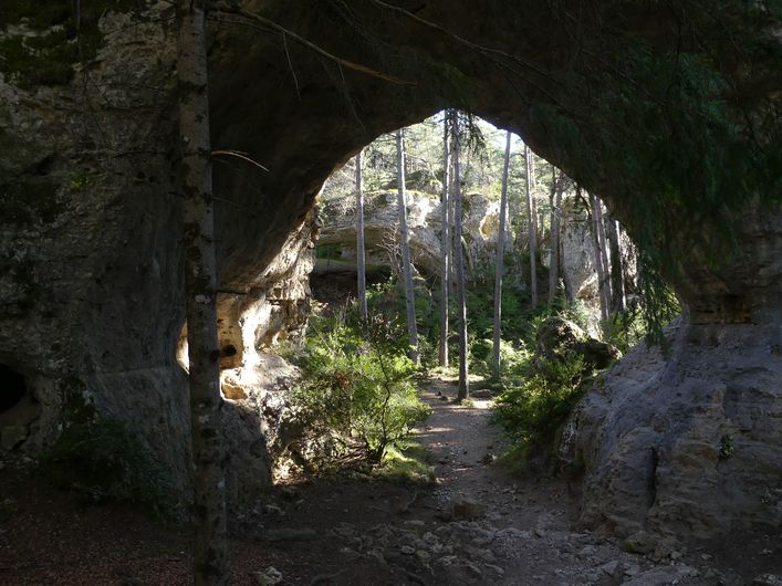
The arches of Saint-Pierre
Erosion has sculpted the rock into strange shapes and opened up arches, under which are rock shelters, a large square with a hoodoo (fairy chimney) and a cave tomb, where around 3,500 BC audacious trepanning was carried out.
3 points of interest
Grotte de l'homme mort - Nathalie Thomas  History
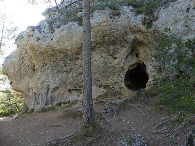
L'Homme-Mort (Dead Man’s) Cave
In 1867 Dr Barthélémy Prunières and Prof Paul Broca discovered some 50 human skeletons from the Chalcolithic or Copper Age (2,200 to 1,800 BC) in this cavity with its almost round entrance. It was the first ever discovery in France of skulls bearing signs of trepanning-style lesions that were in the process of scarring over. Trepanning was carried out using a flint drill. The surgeon operated rather brutally to begin with, but once the cancellous bone had been penetrated, he seems to have drilled into the internal table of the skull bone more carefully. The individuals treated in this way were normally adults.
In some cases, where the skull had previously been staved in, the purpose was probably to relieve the injury.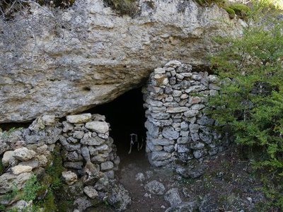
Ancien village de résiniers - Nathalie Thomas HistoryVillage of resin workers
The ancient village, too hastily called prehistoric, was in fact a resin workers’ village from the Gallo-Roman period. You can still see some dry-stone walls and, on certain rocks, notches to hold up the beams that supported the roofs. The resin workers collected pine resin to heat the potters’ kilns in La Graufesenque (Millau), which was transported by floating it to the River Tarn. The resin was extracted by distilling bark and branches left on-site and stored in urns. The pitch produced in this way was used to caulk* boats.
(*filling holes in a boat’s hull using tarred fibres)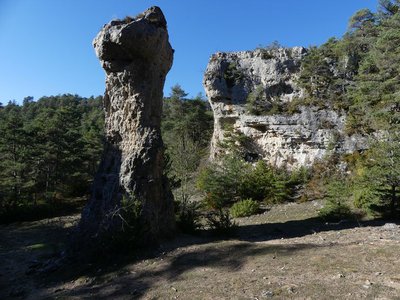
La grand place - Nathalie Thomas  Geology
The ancient village, too hastily called prehistoric, was in fact a resin workers’ village from the Gallo-Roman period. You can s
This blockfield was shaped by the elements, which dissolved the soft limestone, leaving behind the less soluble dolomite* looking like lanes, squares, crossroads, etc. The “large arches” and the “large square” seem to be the only remnants of a very old and very substantial underground network, which has collapsed. Only a few parts of the vault remain: the arches.
(*a sedimentary rock composed of a carbonate that is equal parts calcium and magnesium)
Description
From the parking area at the crossroads of the roads to La Viale and Le Truel, take the sandy path, close the gate and continue for 400 m.
- Leave the path for a small path on the right that runs alongside a fence. It follows an old track bordered by low walls.
- Turn downhill on the right, pass between two rocks and immediately take the path on the right (stepped section).
- Turn left and immediately right. The path goes uphill, including on stairs.
- Take, on your right, the steep descent. Then turn left and continue to go downhill towards the arches.
- Pass under the first arch, then under the second arch on your left. Go uphill on the path that heads to the right, then to the left, to reach Point 4. Go right to get back to Point 3.
- Turn left and go uphill to La Baumelle cave, which you cross to the left. Continue uphill until you reach the road. Head right, pass between two new houses, and turn right onto the road to return to the village of Saint-Pierre des Tripiers.
- At the crossroads, take the road on the right, towards Le Truel. After 150 m, at the cross, turn left to return to the hamlet of La Viale. In the hamlet, take the road on the right to return to your starting-point.
- Departure : Crossroads with La Viale road
- Arrival : Crossroads with La Viale road
- Towns crossed : Saint-Pierre-des-Tripiers
Forecast
Altimetric profile
Recommandations
Make sure your equipment is appropriate for the day’s weather conditions. Remember that the weather changes quickly in the mountains. Take enough water, wear sturdy shoes and put on a hat. Please close all gates and barriers behind you.
Information desks

Tourism'house and national Parc at Florac
Place de l'ancienne gare, N106, 48400 Florac-trois-rivières
This office is part of the National Park's associated tourist-information network, whose mission is to provide information on, and raise awareness of, the sites and events as well as the rules that must be observed in the National Park's central zone.
On site: exhibitions, video projections, events and shop Open year-round
Access and parking
From La Parade, take the D63, then head towards Saint-Pierre des Tripiers, then towards La Viale.
Parking :
Calculateur d'itinéraire Lio
Utilisez le calculateur liO pour organiser votre trajet en région Occitanie.
Autres régions
Calculez votre itinéraire en Auvergne Rhône Alpes sur Oùra
Biodiversité autour de l'itinéraire
Source


Report a problem or an error
If you have found an error on this page or if you have noticed any problems during your hike, please report them to us here: