
La Devinayre
This 16 km hike lets you explore several typical Cévenol hamlets and villages, walk through chestnut orchards and, from the ridge, admire the magnificent landscape.
3 points of interest
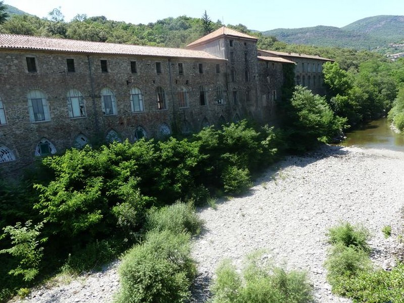
La belle filature du Mazel - Michel Monnot  History
The spinning-mill
From the car park, you can see the imposing buildings of the former spinning-mill by the river. Flowing water was indispensable for spinning-mills to work: its energy was used to turn the spools (guindres), around which the silk thread was wound, and for the throwing, which consisted of twisting and spinning the silk.
We do not know who built the first building but a forge was set up in 1806, and in 1943 the building was home to both a throwing mill and a spinning-mill. The second building was added in 1856, and in 1900 they both had electric lighting installed. In 1936, the whole complex was managed by the Société des Filatures de Soie des Hautes Cévennes [Upper Cévennes silk spinnning-mills company]". In 1984, Bresson-Rande still had a hosiery workshop here. In 1995, all activity on the site ceased.
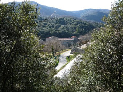
Notre-Dame en fond - Michel Monnot HistoryNotre-Dame-de-la-Rouvière
Notre-Dame-de-la-Rouvière (from rovière, an area planted with English oaks) is one of the few villages in the Protestant Cévennes that remained entirely Catholic during the Camisard War, despite acts of intimidation. In the early 17th century, a Huguenot leader, the Duke of Rohan, wanted to force Catholic communities to convert to Protestantism. He rounded up the notables of Saint-Martial, Saint-André-de-Majencoules and Notre-Dame-de-la-Rouvière to make them renounce their faith. Terrified, they accepted the Duke’s proposal but only on condition of a pact of "recobre" (redemption). The duke, unaware of the meaning of the word, signed the treaty.
After the Peace of Nîmes, the three communities thus returned to the bosom of the Catholic Church in accordance with the condition that they had imposed. (Ici en Cévennes, joint publication with the state school in Notre Dame de la Rouvière, 1994)
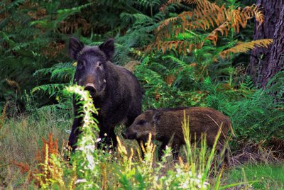
Les sangliers - Emilien Herault  Fauna
FaunaWild boar
The wild boar has become the most abundant large animal species in the Cévennes, where two centuries ago it was rare. Abandoned chestnut orchards provide the boar with ample food, and the less harsh winters and larger litters favour its reproduction. Boar populations are increasing, as are the traces of their presence: wallows where they cover themselves in mud; ground that has been ploughed by them, sometimes over large areas; rub marks on trees, especially conifers, to mark territory. Both male and female wild boar have tusks, the males’ being more imposing.
The sow gives birth to 1 to 10 striped boarlets per litter. Female and young wild boar live in “companies” whereas the males are solitary.
Description
Signposts will guide you all along this route, as well as yellow painted waymarks. In the description below, the signposted place names and/or directions are given in bold italics between quotation marks:
From the signpost “Peyregrosse” on the car park, go towards
- “Les Tronquisses”. At “Les Tonquisses”, turn left towards
- "Ambec",
- “Notre-Dame-de-la-Rouvière”. Walk through the village and at the signpost “Notre Dame de la Rouvière”, take the road on the right towards
- “Col de la Tribale”. At “Col de la Tribale”, go towards “Le Pèze”, taking the D 420 road for 400 m.
- At “Le Pèze”, take “Col de Devinayre".
- At "Col du Devinayre", continue on
- “Le Trainier”,
- “Col de Peyreraube”,
- "Valbonne",
- "Col des Cabones",
- “Les Tronquisses”, and return to the car park "Peyregrosse".
- Departure : Peyregrosse
- Arrival : Peyregrosse
- Towns crossed : Saint-André-de-Majencoules, Val-d'Aigoual, Saint-Martial, and Sumène
Forecast
Altimetric profile
Recommandations
Before committing yourself to a circuit, ensure that it is suitable for your activity level and ability. Remember that the weather changes quickly in the mountains. Take enough water.
Information desks

Tourism & national parc'house
Col de la Serreyrède, 30570 Val d'Aigoual
The Maison de l'Aigoual houses the tourism office Mont Aigoual Causses Cévennes and the Maison du Parc national. This visitor centre provides information on and raises awareness of the Cévennes National Park, its sites and events as well as the rules that must be observed in the National Park's central zone.
On site: changing exhibitions, video projections, Festival Nature events and shop Open year-round
Tourism office Mont Aigoual Causses Cévennes, Valleraugue
7 quartier des Horts, 30570 Valleraugue
This office is part of the National Park's associated tourist-information network, whose mission is to provide information on, and raise awareness of, the sites and events as well as the rules that must be observed in the National Park's central zone. : Open year-round
Transport
liO is the regional public transport service of the Occitanie/ Pyrénées – Méditerranée region. It facilitates everyone’s movements by prioritising public transport. For more information, go to the lio Occitanie app or visit https://ww.mestrajets.lio.laregion.fr
(in term time)
Access and parking
At Pont de l’Hérault, go towards Valleraugue, drive for 6 km on the D 986, until you reach Peyregrosse – car park after the bridge, on the road to the Col de la Tribale pass.
Parking :
Calculateur d'itinéraire Lio
Utilisez le calculateur liO pour organiser votre trajet en région Occitanie.
Autres régions
Calculez votre itinéraire en Auvergne Rhône Alpes sur Oùra
Biodiversité autour de l'itinéraire
Source


Report a problem or an error
If you have found an error on this page or if you have noticed any problems during your hike, please report them to us here: