
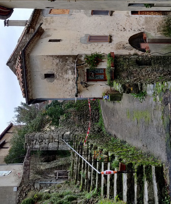
Les Rouquis
The path climbs into the chestnut and holm oak grove. Steps carved into the granite bedrock bear witness to its regular use. The hamlet of La Rouviérette, located on the draille (drovers’ road), is a stopover place for transhumant shepherds going up onto summer pastures with their sheep. Up there, the views over the surroundings slopes are panoramic.
2 points of interest
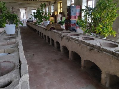
Intérieur de la filature - Beatrice Galzin  History
The spinning-mill
The spinning-mill was built out of shaped blocks of granite in 1825, under the supervision of the architect Victor Chapot of Le Vigan and its owner M. Durand.
On the ground floor were the (GENSOUL type) furnace, the ovens [for asphyxiating the silkworms using hot air], the vast wood stores and the stables and yards for the horses.
On the first floor was the spinners’ workshop with its 54 circular terra cotta bassins (still visible) and rows of swifts (reels) that have since disappeared.
The top floor was home to the nursery, the storage area for the silk cocoons.
The silkworm disease pébrine (1856), the opening of the Suez Canal (1869), artificial silk (1884) and the owner’s death put an end to this beautiful adventure.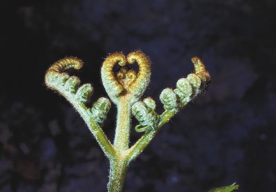
Naissance de la fougère aigle - PNC  Flora
FloraBracken
Since the abandonment of the chestnut orchard, the bracken, which was once cut and used as litter and fodder for animals, has spread. Some locals still remember that bracken fronds were given to pigs to eat with water and flour.
Description
Signposts will guide you all along this route. In the description below, the signposted place names and/or directions are given in bold italics between quotation marks:
From the car park in "Saint- André-de-Majencoules", walk towards "La Rouviérette" via
- "L’Église",
- "Ancienne filature",
- "Le Buis".
- "La Rouviérette Sud",
- At "La Rouvièrette" walk through the hamlet and continue to "Combe Croze".
- At “Combe Croze” leave the path on your right and continue to “Le Rouquis”.
- At “Le Rouquis” leave the GR® long-distance path and head to
- "Laparot",
- "Parc du Château",
- "L'Église".
- "Saint- André-de-Majencoules".
- Departure : Saint- André-de-Majencoules
- Arrival : Saint- André-de-Majencoules
- Towns crossed : Saint-André-de-Majencoules
Forecast
Altimetric profile
Recommandations
Somewhat steep descent. Before committing yourself to this walk, ensure that it is suitable for your activity level and ability. Remember that the weather changes quickly in the mountains. Take enough water.
Information desks

Tourism & national parc'house
Col de la Serreyrède, 30570 Val d'Aigoual
The Maison de l'Aigoual houses the tourism office Mont Aigoual Causses Cévennes and the Maison du Parc national. This visitor centre provides information on and raises awareness of the Cévennes National Park, its sites and events as well as the rules that must be observed in the National Park's central zone.
On site: changing exhibitions, video projections, Festival Nature events and shop Open year-round

Tourism office Mont Aigoual Causses Cévennes, Valleraugue
7 quartier des Horts, 30570 Valleraugue
This office is part of the National Park's associated tourist-information network, whose mission is to provide information on, and raise awareness of, the sites and events as well as the rules that must be observed in the National Park's central zone. : Open year-round
Transport
LiO is the regional public transport service of the Occitanie/ Pyrénées – Méditerranée region. It facilitates everyone’s movements by prioritising public transport.
(during school time)
Access and parking
At Pont de l’Hérault, take the D986 towards Valleraugue, then the D420 to the village of Saint-André-de-Majencoules
Parking :
Calculateur d'itinéraire Lio
Utilisez le calculateur liO pour organiser votre trajet en région Occitanie.
Autres régions
Calculez votre itinéraire en Auvergne Rhône Alpes sur Oùra
Biodiversité autour de l'itinéraire
Source


Report a problem or an error
If you have found an error on this page or if you have noticed any problems during your hike, please report them to us here: