
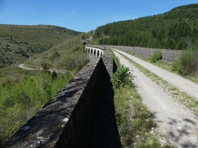
The viaducts
3 points of interest
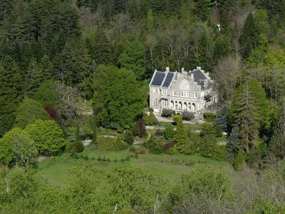
Château du Mazel - Nathalie Thomas  History
Jean Charles Arnal de Curel
A lawyer by training, de Curel took holy orders in 1886, aged 28. Ordained in Nîmes, he was appointed canon of the cathedral there before a short stay in Algeria. In 1903, he was appointed bishop of Monaco, in which post he remained until his death in 1915. A lover of literature and the arts, he bought the Le Mazel estate in Alzon, where he had the strange château of the same name built. On his death, he left it to the bishopric of Nîmes, which turned it into a bishops’ summer residence until 1982. De Curel’s gifts and donations also made it possible to restore the facade of the church. As of 1914, he had the project of erecting a statue of the Virgin Mary on the Roche aux Fées rocks. (Le Vigan tourism office)
Mur de soutènement - Nathalie Thomas HistoryThe railway and its structures
The very undulating railway line (altitude at Le Vigan: 220 m; at Col du Vassel: 808 m; at Tournemire: 496 m) made it necessary to build a large number of structures (12 viaducts and 32 tunnels). These works employed almost 3,000 workers as well as 1,000 horses and mules for transport. The cost of the railway line was 21 million gold francs. In the early 20th century there were four trains a day, taking about two-and-a-half hours to cover the 61.8 km. In 1932, 136,000 passengers and 33,086 tonnes of goods used the line. In 1938, traffic collapsed: the number of users dropped to 25 a day and freight to 14,702 tonnes a year, leading to the closure of the line on 15 May 1939. It continued to see limited use until 1980; on the Tournemire-L'Hospilate du Larzac section, this was mostly for military purposes.
La voie ferrée - Nathalie Thomas HistoryThe Le Vigan-Tournemire railway
The Le Vigan-Tournemire railway was built to complete the existing rail infrastructure between the Massif Central, the Millau, Rodez and Albi areas, the coastal plain and the major port of Marseilles. Work on the 61.8 km of the lines started in 1885 and took 11 years: the inauguration date was 25 August 1896. During construction, the inhabitants of Alzon complained about their station being far away. The authorities replied that “given the steep slopes, there was no alternative”. When the line was disused, the station buildings were bought by the National Forestry Office to turn them into a forester’s house that could replace the one at Cazebonne.
Description
Signposts will guide you all along this route. In the description below, the signposted place names and/or directions are given in bold italics between quotation marks:
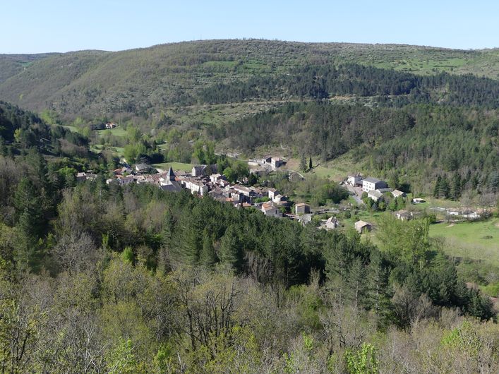
Starting at “ALZON", follow "Sous la Vierge". From here, optional there-and-back to the statue of the Virgin Mary.
- Continue towards "Rocamousse",
- Then "Passerelle de la Vis" and "Les Lauriers".
- Then walk to “Valcroze” via “Chemin de Gleize”.
- At "Valcroze", return to “ALZON" via "Pont de Saurel".
This walk is taken from the guidebook Les Vallées Cévenoles - En Pays Viganais, published by the Communauté de communes Pays Viganais-Cévennes as part of the collection Espaces Naturels Gardois and the label Gard Pleine Nature.
- Departure : Alzon, information panel
- Arrival : Alzon, information panel
- Towns crossed : Alzon and Campestre-et-Luc
Forecast
Altimetric profile
Recommandations
You will need a torch for the first tunnel. Make sure your equipment is appropriate for the day’s weather conditions. Take enough water, wear sturdy shoes and put on a hat. Please close any gates and barriers behind you.
Information desks

Tourism office Cévennes and Navacelles, Le Vigan
Maison de pays, place du Marché, BP 21, 30120 Le Vigan
This office is part of the National Park's associated tourist-information network, whose mission is to provide information on, and raise awareness of, the sites and events as well as the rules that must be observed in the National Park's central zone.
Open year-round
Transport
liO is the regional public transport service of the Occitanie/ Pyrénées – Méditerranée region. It facilitates everyone’s movements by prioritising public transport. For more information, go to the lio Occitanie app or visit https://www.mestrajets.lio.laregion.fr
Access and parking
Take the D999 or D231 or D814
Parking :
Calculateur d'itinéraire Lio
Utilisez le calculateur liO pour organiser votre trajet en région Occitanie.
Autres régions
Calculez votre itinéraire en Auvergne Rhône Alpes sur Oùra
Biodiversité autour de l'itinéraire
Source


Report a problem or an error
If you have found an error on this page or if you have noticed any problems during your hike, please report them to us here: