
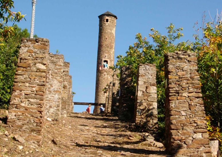
Les Luminières
This path leading to Le Simonet’s headframe (mine tower) shows you the traces of an ingenious system for transporting coal, whose remains still cling to the slope. From the ghost hamlet of Les Luminières, you have a good view over these vestiges of open-cast coal mining from the 20th century. Le Simonet’s headframe takes centre stage among the pine trees, overlooking a vertiginous inclined plane.
Forecast
Altimetric profile
Recommandations
For your own safety and to preserve the site, you must stay on the marked path
Information desks

Tourism office Cévennes Tourism, La Grand-Combe
Maison du mineur, rue Victor Fumat, 30110 La Grand-Combe
This office is part of the National Park's associated tourist-information network, whose mission is to provide information on, and raise awareness of, the sites and events as well as the rules that must be observed in the National Park's central zone.
Open year-round
Access and parking
From Florac or Alès on the N106 to La Haute-Levade (in the municipality of Sainte-Cécile d’Andorge)
Parking :
Calculateur d'itinéraire Lio
Utilisez le calculateur liO pour organiser votre trajet en région Occitanie.
Autres régions
Calculez votre itinéraire en Auvergne Rhône Alpes sur Oùra
Biodiversité autour de l'itinéraire
Source
Report a problem or an error
If you have found an error on this page or if you have noticed any problems during your hike, please report them to us here: