
The 3 passes of L’Escoutadou (Trail)
4 points of interest
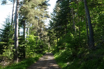
Chemin dans la forêt - Michel Monnot  Natural environment
Beech trees and the Mont Aigoual forest
Beech is the main species of the Mont Aigoual forest, which consists of a large variety of trees adapted to the diverse soil types and exposure. Like most deciduous trees, beech stumps put out many shoots after a tree has been felled. Foresters select the best of these for timber. Old beeches can attain remarkable sizes, such as the beech in Le Suquet forest in the municipality of Camprieu, a vestige of the original forest that has come down to us through the centuries and has a circumference of six metres and a height of 25!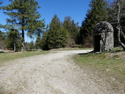
Col de la Caumette - nathalie.thomas  History
The salt road
La Caumette pass is on a former salt road. From Antiquity to modern times, salt has been a precious merchandise used for preserving food and tanning leather. Salt has always been traded and taxed during its transport inland from the Mediterranean coast. The sentry box at the pass was built in the 16th or 17th century at a strategic point at the crossroads of several roads, both to levy the salt tax and for surveillance against smuggling.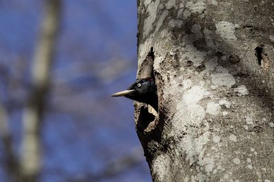
Le pic noir - Jean-Pierre.Malafosse  Fauna
FaunaThe black woodpecker
The black woodpecker is the largest of our woodpeckers and reappeared in the massif in 1936. Gripping wood with its claw, supported by its very stiff tail, it hammers a large hole (diameter over 30 cm) into the trunk of a beech: its nesting chamber, in which it will reproduce. The hole must be located over 6 m above ground, and its oval entrance must open onto a clear space to facilitate take-off. Abundant food must be available: ant hills; diseased or dead conifers that the black woodpecker will riddle with holes to extract larvae; pine or spruce cones that it will wedge into those holes to pick out the seeds. You may hear its call, a powerful “kree-kree”!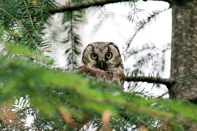
La chouette de tengmalm - Gaël.Karczewski FaunaBoreal owl
Abandoned woodpecker chambers are a boon for small mammals and other birds, such as the boreal owl, which has come from Nordic countries to settle here at altitudes of 800 m. Very discreet, it confines itself to the depths of our forested mountain ranges. It can be identified in March by its sonorous and gentle call. To maintain the species, the Cévennes National Park and the French forestry office protect trees with nesting chambers and old-growth forests from being logged.
Description
Signposts will guide you all along this route. In the description below, the signposted place names and/or directions are given in bold italics between quotation marks :
From “Col de La Serreyrède”, run to “Station de Prat Peyrot” via:
- “Le Fangas” :
- From “Station de Prat Peyrot”, run to
- “Les Fayards”
- “Col de la Caumette”. Return to “Col de La Serreyrède” via:
- “L’Escoutadou”.
This trail is taken from the guidebook Massif de l’Aigoual, published by the communauté de communes Causses Aigoual Cévennes as part of the collection Espaces naturels gardois and the label Gard Pleine nature.
- Departure : Col de La Serreyrède
- Arrival : Col de La Serreyrède
- Towns crossed : Val-d'Aigoual and Meyrueis
Forecast
Altimetric profile
Recommandations
Before committing yourself to a circuit, ensure that it is suitable for your activity level and ability. Remember that the weather changes quickly in the mountains. Take enough water. Please close all gates and barriers behind you.
Information desks

Biosphera
18, rue vincent Faita, 30480 Cendras
Transport
LiO is the regional public transport service of the Occitanie/ Pyrénées – Méditerranée region. It facilitates everyone’s movements by prioritising public transport. For more information, go to the lio Occitanie app or visit https://www.mestrajets.lio.laregion.fr
Access and parking
From Valleraugue, take the D986 to the village of L’Espérou. At the roundabout, turn right to the Col de la Serreyrède pass.
Parking :
Calculateur d'itinéraire Lio
Utilisez le calculateur liO pour organiser votre trajet en région Occitanie.
Autres régions
Calculez votre itinéraire en Auvergne Rhône Alpes sur Oùra
Biodiversité autour de l'itinéraire
Source


Report a problem or an error
If you have found an error on this page or if you have noticed any problems during your hike, please report them to us here:
