
L'Oustal Crémat
3 points of interest
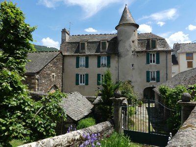
Château de Bagnols les Bains - N Thomas  History
Château
The little château that you pass was built in the 17th century on the road from Florac to Bagnols. Its tower hides a handsome spiral staircase. For 59 years, this fortified building was the base of the mounted gendarmerie. The stables were on the ground floor. In 1966, the gendarmes moved into accommodation lower down in the village.
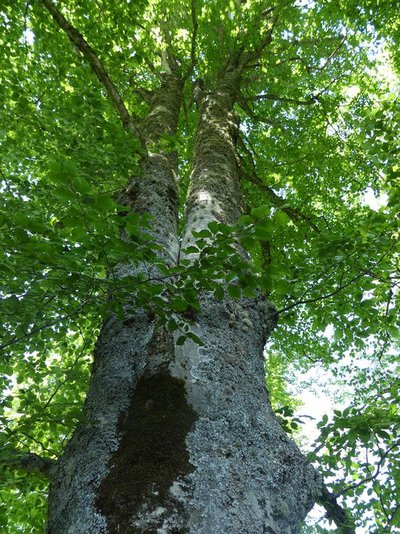
Les belles forêts - N Thomas  Flora
FloraForest atmosphere
You are walking through a wood where white oak, beech and whitebeam make harmonious neighbours, including some impressive specimens. Further on, Austrian pine predominates, being well-adapted to the schist bedrock, before giving way to fayards (beeches) again. Lower down, along the Rieu Frech brook, you can see firs whose long needles are bluer than other trees’ and point upwards like half-brushes: white or Colorado firs (Abies concolor). They were chosen for their ability to adapt to the local climate.
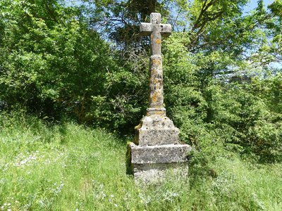
Croix de l'Oustal Crémat - N Thomas HistoryCrosses
This is one of the very many crosses to be found in Lozère, especially in the upper Lot valley. Cross makers, the best known of which is Jean du Born in the 17th century, worked with materials found in the region. For at least six centuries, crosses were erected along paths in Lozère to assume a variety of functions: limit or path markers, memorials, places of contemplation, calvary or pilgrimage site, event, expression of individual or village piety, etc. Over 400 survived the Wars of Religion and then the Terror that followed the French Revolution. The most recent crosses have, since the 19th century, been made of forged iron. Some of them have been fixed on older bases or tree boles.
Description
Signposts will guide you all along this route. In the description below, the signposted place names and/or directions are given in bold italics between quotation marks:
Starting at "Bagnols-les-bains", follow "l'Oustal Crémat" via :
- « Avenue de la gare »,
- « Route de la Loubière »,
- « Rue de la Jarretière »,
- « Lou Contrat »,
- « Menhir »,
- At « L’Oustal Crémat » return to « Bagnols les Bains » via « Les Menhirs »,
- « Les Faissettes »,
- « Les Goutelles »,
- Return to « Rue de la Jarretière », « Route de la Loubière » and « Avenue de la Gare »
This hike is taken from the guidebook Mont Lozère - Pays des sources, de la montagne du goulet aux gorges du Bramont, published by the Pôle de pleine nature du Mont Lozère.
- Departure : Bagnols-les-Bains
- Arrival : Bagnols-les-Bains
- Towns crossed : Mont Lozère et Goulet and Chadenet
Forecast
Altimetric profile
Recommandations
Make sure your equipment is appropriate for the day’s weather conditions. Remember that the weather changes quickly in the mountains. Take enough water, wear sturdy shoes and put on a hat. Please close any gates and barriers behind you.
Information desks

Tourism office Mont-Lozère, Bagnols-les-Bains
avenue de la gare, 48190 Bagnols-les-Bains Mont-Lozere et Goulet
This office is part of the National Park's associated tourist-information network, whose mission is to provide information on, and raise awareness of, the sites and events as well as the rules that must be observed in the National Park's central zone. Open from mid-April to late September
Transport
This hike is accessible by public transport only in summer.
To consult the updated schedules and plan your trip, use the route calculator below by entering the arrival stop: MONT LOZÈRE ET GOULET - Bagnols les Bains - Av Soleil
Access and parking
From Mende, drive towards Badaroux on the N 88, then take the D 901 direction Ste-Hélène to Bagnols-les-Bains.
Parking :
Calculateur d'itinéraire Lio
Utilisez le calculateur liO pour organiser votre trajet en région Occitanie.
Autres régions
Calculez votre itinéraire en Auvergne Rhône Alpes sur Oùra
Biodiversité autour de l'itinéraire
Source


Report a problem or an error
If you have found an error on this page or if you have noticed any problems during your hike, please report them to us here: