
Mont Lozère in a nutshell, (variant) Trail #14V
4 points of interest
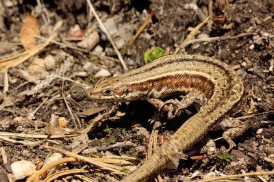
Le lézard vivipare - Bruno Descaves  Fauna
FaunaThe viviparous lizard
Everybody knows the sun-loving common wall lizard. But another small lizard, the viviparous lizard, lives in the mountains, in the same environments that the common frog likes. Its belly is uniformly yellow or orange in females, dotted black in males. In the Cévennes, this lizard is found in peatbogs, near rivers, in meadows and heath moors and right up to the edge of beech forests. It never strays far from its home. Only love will push the male to cover 10 or 20 metres in search of a mate. As the species name indicates, the female gives birth to young that are fully formed and immediately independent. This reproductive strategy is much better adapted to the cold.
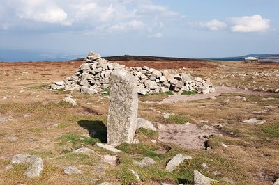
Croix de Malte - Guy Grégoire  History
The Knights Hospitaller
"It is an enormous farm. From the 11th to the 14th century, some of its revenues were used to finance the fight against the Muslims. As of 1530, the order of the Knight Hospitallers (first headquartered at Saint John of Jerusalem, then on Rhodes), became the order of the Knights of Malta, Emperor Charles V having granted them the island of that name. At the time, there were another 257 commanderies of the Knights of Malta in France; all of them were sold during the French Revolution.
For centuries, these monks and knights criss-crossed the “tundra” of Mont Lozère with their herds of sheep and horses bred for their brothers in the East. (…) These open spaces also provided them with precious fuel for the fire, plants for animal litter, game, etc.” (B. Matthieu, "Les chemins ont une histoire")
Shortly before the shepherd’s hut you can see a Maltese cross carved into a standing stone. It is a boundary marker.
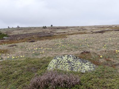
Finiels - N.Thomas_pnc  Flora
FloraFiniels summit
The short-grass prairie consisting of a coarse grass species called matgrass adapts to harsh weather conditions at altitude. In the spring, wavy snow dunes form in some hollows; small heaps seek shelter behind shrubs. The Eurasian skylark, meadow pipit and common linnet already try to cross the summit by fluttering close to the ground. On the summit itself, some islands of callune (heather, which has the particularity of flowering first at altitude) and some blueberry plants manage, with great difficulty, to establish themselves. Boundary stones have Maltese crosses carved into them. In the 12th century, Baron de Tournel gifted land located on the southern slopes of Mont Lozère to the Knights of Saint-John of Jerusalem. In the 16th century, this order became the Order of the Knights of Malta. The commandery was set up at L'Hôpital and its land delimited by these boundary markers.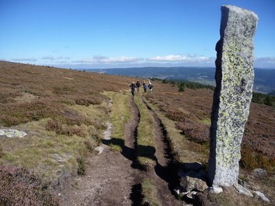
Les montjoies - Nathalie Thomas HistoryThe montjoies (cairns)
The "small menhirs" called montjoies that mark out the path did not grow by themselves.... Or rather, their origins were so long ago that nobody remembers. No matter! Look at these boundary markers and imagine for a moment that you are a giant who, after reading Hansel and Gretel, finds himself caught in a tourmente (heavy snowstorm and fog). Wouldn’t you have had the idea of planting a few pointed pebbles two-and-a-half metres high to be able to find your way back?
Description
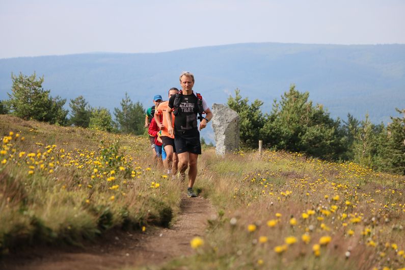
A steeper section on a narrow path to reach the summit. Time for photos – and windcheaters!
A stroll on the ridge, then an enjoyable descent on the GR®70 long-distance hiking path, punctuated by mythical cairns.
This trail is a short version of the trail "Mont Lozère in a nutshell", #14.
Follow the waymarks for trail #14v.
Signposts will guide you all along this route, as well as yellow painted waymarks. In the description below, the signposted place names and/or directions are given in bold italics between quotation marks:
From "Station du Mont-Lozère", go to "Parking des Chômeurs" via "La Chapelle du Mont Lozère".
Then head to "Sommet de Finiels" via "Route des Chômeurs".
At "Sommet de Finiels", return to "La Station du Mont-Lozère" via "Col de la draille", "Parking des chômeurs", "La Chapelle du Mont-Lozère".
This trail is taken from the guidebook Mont Lozère – Pays des sources, published by the Pôle de pleine nature du mont Lozère.
- Departure : Station du Mont-Lozère (ski and outdoor resort)
- Arrival : Station du Mont-Lozère
- Towns crossed : Cubières, Mont Lozère et Goulet, and Pont de Montvert - Sud Mont Lozère
Forecast
Altimetric profile
Recommandations
Caution: patous (livestock guard dogs)! Seek advice on how to behave near these dogs from tourist offices and National Park information centres.
Before committing yourself to a circuit, ensure that it is suitable for your activity level and ability. Remember that the weather changes quickly in the mountains. Please close all gates and barriers behind you. Stay on the marked path.
Information desks

Tourism office Coeur de Lozère, Mende
BP 83, place du Foirail, 48000 Mende
This office is part of the National Park's associated tourist-information network, whose mission is to provide information on, and raise awareness of, the sites and events as well as the rules that must be observed in the National Park's central zone.
Open year-round

Office de tourisme Des Cévennes au mont Lozère
le Quai, 48220 Le Pont de Montvert sud mont-Lozère

Tourism office Mont-Lozère, Villefort
43, Place du Bosquet, 48800 Villefort
This office is part of the National Park's associated tourist-information network, whose mission is to provide information on, and raise awareness of, the sites and events as well as the rules that must be observed in the National Park's central zone.
Open year-round

Le Mas de la Barque outdoor centre
48800 Villefort
This centre is part of the National Park's associated tourist-information network, whose mission is to provide information on, and raise awareness of, the sites and events as well as the rules that must be observed in the National Park's central zone.
Transport
https://ww.mestrajets.lio.laregion.fr
Access and parking
From Le Bleymard, to Station du Mont-Lozère on the D 20.
Parking :
Calculateur d'itinéraire Lio
Utilisez le calculateur liO pour organiser votre trajet en région Occitanie.
Autres régions
Calculez votre itinéraire en Auvergne Rhône Alpes sur Oùra
Biodiversité autour de l'itinéraire
Source


Report a problem or an error
If you have found an error on this page or if you have noticed any problems during your hike, please report them to us here: