
The tumulus of L’Elzière
2 points of interest
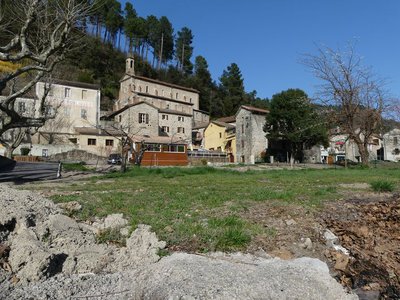
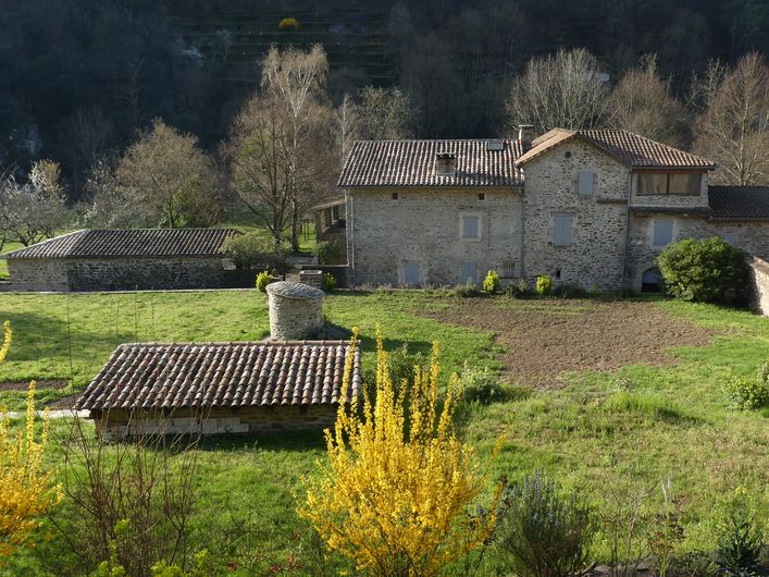
Le Chambon - Nathalie Thomas  History
Le Chambon
The history of Le Chambon is turbulent and set to the rhythm of its successive owners: feudal lords, the parish, the school authorities and the village council.
The oldest parchment dates to 17 April 1295. It refers to the sale of the fiefdom of Le Chambon to the Lord of Portes, whose property it remained until the 17th century, when it was bought by Mr Roussel. It later became part of Sénéchas. Le Chambon did not become its own municipality until 1839, when it had around 800 inhabitants.
After endless debates about how far away the surrounding churches were, le Chambon built its own in 1889. At the time, its lanes were animated by two schools, six cafés, many artisans and miners. When the coal mines closed in the 1950s, the village began to empty. Today, green tourism is reviving it.
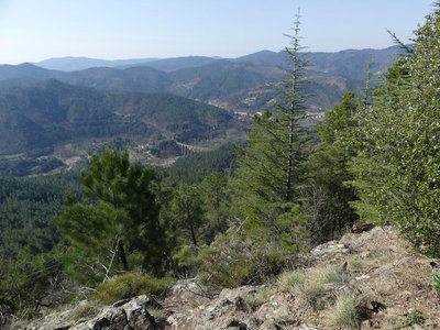
Vue sur le Viaduc - Nathalie Thomas  Landscape
The tumulus of L’Elzière
This monument dating from the late Bronze Age was reused in the Iron Age and Middle Ages. The burial mound (heap of stones) is circular, with a diameter of 20 m and a height of 4 m. Remarkably, it is built in tiers. The grave, located centrally, consists of a caisson. In it were discovered pottery shards that may have contained drinks and meat as well as a decorated razor blade and a flint arrowhead. These grave goods are preserved at the Musée du Colombier in Alès, in an 18th century former château.
Description
Signposts will guide you all along this route. In the description below, the signposted place names and/or directions are given in bold italics between quotation marks :
Start at the village car park “Le Chambon-parking” go to :
- “Chambon-Eglise”, continue to “Sénéchas” via :
- “Le Recul”
- “Le Tribes”. At “Le Tribes”, walk to “Tumulus de l’Elzière” via :
- “Le Claud”,
- “Les Boissonnades”
- “La Mole”. From the signpost “La Mole”, head to the “Tumulus” and then return to “La Mole” before going downhill to :
- “Dieusses” to return to “Le Chambon” via :
- “Le Martinet Neuf”
- “Pont sur Luech”. Return to the parking.
This hike is taken from the guidebook Mont Lozère – Pays des sources, Sommet des Cévennes, published by the Pôle de pleine nature du Mont Lozère.
- Departure : Le Chambon
- Arrival : Le Chambon
- Towns crossed : Chambon and Sénéchas
Forecast
Altimetric profile
Recommandations
Some sections are rocky and close to the cliff edge: supervise your children !
Make sure your equipment is appropriate for the day’s weather conditions. Remember that the weather changes quickly in the mountains. Take enough water, wear sturdy shoes and put on a hat. Please close any gates and barriers behind you.
Information desks

Tourism'house and national Parc at Florac
Place de l'ancienne gare, N106, 48400 Florac-trois-rivières
This office is part of the National Park's associated tourist-information network, whose mission is to provide information on, and raise awareness of, the sites and events as well as the rules that must be observed in the National Park's central zone.
On site: exhibitions, video projections, events and shop Open year-round
Tourism'house and national parc, Génolhac
Place du Colombier, 30450 Génolhac
This office is part of the National Park's associated tourist-information network, whose mission is to provide information on, and raise awareness of, the sites and events as well as the rules that must be observed in the National Park's central zone.
Open from april to october

Tourism office Mont-Lozère, Villefort
43, Place du Bosquet, 48800 Villefort
This office is part of the National Park's associated tourist-information network, whose mission is to provide information on, and raise awareness of, the sites and events as well as the rules that must be observed in the National Park's central zone.
Open year-round
Access and parking
From Génolhac, take the D906 to Chamborigaud, then the D29 to Le Chambon
Parking :
Calculateur d'itinéraire Lio
Utilisez le calculateur liO pour organiser votre trajet en région Occitanie.
Autres régions
Calculez votre itinéraire en Auvergne Rhône Alpes sur Oùra
Biodiversité autour de l'itinéraire
Source


Report a problem or an error
If you have found an error on this page or if you have noticed any problems during your hike, please report them to us here: