
The bridges
4 points of interest
balisage du parcours - Nathalie Thomas  History
The Jean-Pierre Chabrol literary circuit
Starting at the mairie (town hall), a literary walk takes you through the village of Chamborigaud in the footsteps of local author Jean-Pierre Chabrol (about 5 km, can also be started at the train station).
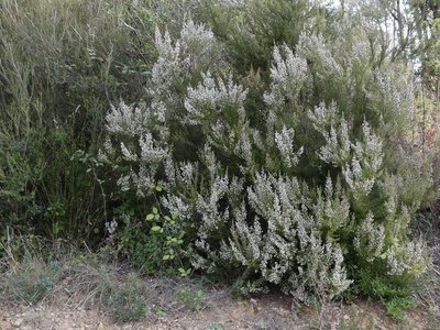
Bruyère blanche - Nathalie Thomas  Flora
FloraTree heather
Do you like heather honey?
Bees love it, and yet the nectar is difficult to harvest!
One of the stickiest of nectars, it makes insects lose time, by trapping them and covering them, forcing them to have a long clean-up after work. But how could bees do without the only nectar on acidic soils that is 20% calcium?
Common and bell heather have a family likeness: they both belong to the Ericaceae. The bells of the bell heather are a strong pink, bigger and urn-shaped. Common heather also has small clusters of flowers, but they are paler and so small that bees visit them less often than those of bell heather.
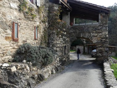
Mas Cotton - Nathalie Thomas HistoryMas du Cotton
“I have happy memories of the days I spent at “Cotton” when I was a child in the 1960s and 70s. The sheepbells moved down the slope of Le Rigal, mixing with the high-pitched calls of the female shepherd dressed in black. Her three sheepdogs helped her funnel the animals to the great door, which has not been changed. (…) In those days, the road wasn’t tarred and life was a calm joy, with chickens leisurely crossing the road from morning to night. The mas [isolated farm or hamlet] was vast and well-run, it smelled of lavender or apples. (…) Forty years later, this scenic ensemble of farmland and handsome traditional houses is still marked by its agricultural past, but I can’t come back here without terrible nostalgia for the flock’s bells and the scent of the lavender that was drying in big bunches on top of the wardrobe”. (B.M.)
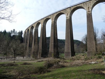
L’imposant viaduc. - Nathalie Thomas HistoryLe Luech bridge
That’s a railway up there, linking Nîmes with Paris!
One hundred and two tunnels were dug and 46 bridges built. The Luech bridge is the most remarkable with its 29 arches, its length of 384 metres and its height of 46m. For 150 years, trains have advanced slowly so as not to derail in the bend. Impossible to gather speed for the abrupt climb into the tunnel!
In the old days, leaves blanketed the rails in the autumn, making the wheels of the heavy convoy slip on this 1-in-40 gradient. Mechanics worried about being left stranded up there.
“While Marius braces himself in front of his voracious firebox, Léon, his hand on the control valve (…), attentive to the smallest sign indicating slippage on the rails, skilfully measures out the power of his 240 [locomotive]” (extract from Les Chevaliers des Cévennes by Raymond Fayvaisse).
Description
Signposts will guide you all along this route. In the description below, the signposted place names and/or directions are given in bold italics between quotation marks :
From the car park of “Chamborigaud” walk to:
- “Stade”, then to “Le Chambon” via :
- “Landiol”,
- “Chemin du Rigal”,
- “Le Rigal”. At the signpost “Le Rigal”, walk to “Chamborigaud” via :
- “Les Taillades”,
- “Landiol”. Return to “Chamborigaud” via “Stade”.
This hike is taken from the guidebook Mont Lozère – Pays des sources, Sommet des Cévennes, published by the Pôle de pleine nature du Mont Lozère.
- Departure : Chamborigaud
- Arrival : Chamborigaud
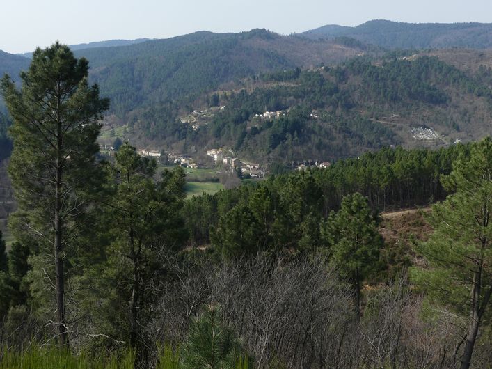
- Towns crossed : Chamborigaud, Génolhac, and Chambon
Forecast
Altimetric profile
Recommandations
Make sure your equipment is appropriate for the day’s weather conditions. Remember that the weather changes quickly in the mountains. Take enough water, wear sturdy shoes and put on a hat. Please close any gates and barriers behind you.
Information desks

Tourism'house and national Parc at Florac
Place de l'ancienne gare, N106, 48400 Florac-trois-rivières
This office is part of the National Park's associated tourist-information network, whose mission is to provide information on, and raise awareness of, the sites and events as well as the rules that must be observed in the National Park's central zone.
On site: exhibitions, video projections, events and shop Open year-round
Tourism'house and national parc, Génolhac
Place du Colombier, 30450 Génolhac
This office is part of the National Park's associated tourist-information network, whose mission is to provide information on, and raise awareness of, the sites and events as well as the rules that must be observed in the National Park's central zone.
Open from april to october

Tourism office Mont-Lozère, Villefort
43, Place du Bosquet, 48800 Villefort
This office is part of the National Park's associated tourist-information network, whose mission is to provide information on, and raise awareness of, the sites and events as well as the rules that must be observed in the National Park's central zone.
Open year-round
Transport
This hike is accessible by public transport.
TER Génolhac – Chamborigaud every day
https://www.thetrainline.com/fr/horaires-train/genolhac-a-chamborigaud
To consult the updated schedules and plan your trip, use the route calculator below by entering the arrival stop: Chamborigaud (Station)
Access and parking
From Génolhac, take the D906 to Pont de Rastel, then to Chamborigaud
Parking :
Calculateur d'itinéraire Lio
Utilisez le calculateur liO pour organiser votre trajet en région Occitanie.
Autres régions
Calculez votre itinéraire en Auvergne Rhône Alpes sur Oùra
Biodiversité autour de l'itinéraire
Source


Report a problem or an error
If you have found an error on this page or if you have noticed any problems during your hike, please report them to us here: