
La Loubière
8 points of interest
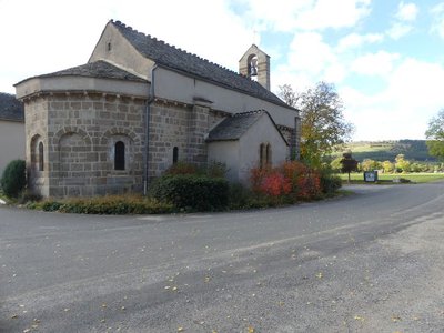
Eglise Saint-Privat - © Nathalie Thomas  History
Saint-Privat’s church
Mentioned for the first time in 1258, Saint-Privat’s church seems to have been built between the 12th and the early 13th century. It was damaged during the French Wars of Religion, like many churches in the Gévaudan. Despite the many overhauls, its architecture is neat.
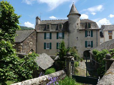
Château de Bagnols les Bains - N Thomas HistoryChâteau
The little château that you pass was built in the 17th century on the road from Florac to Bagnols. Its tower hides a handsome spiral staircase. For 59 years, this fortified building was the base of the mounted gendarmerie. The stables were on the ground floor. In 1966, the gendarmes moved into accommodation lower down in the village.
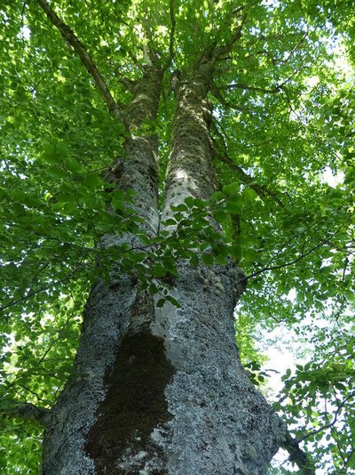
Les belles forêts - N Thomas  Flora
FloraForest atmosphere
You are walking through a wood where white oak, beech and whitebeam make harmonious neighbours, including some impressive specimens. Further on, Austrian pine predominates, being well-adapted to the schist bedrock, before giving way to fayards (beeches) again. Lower down, along the Rieu Frech brook, you can see firs whose long needles are bluer than other trees’ and point upwards like half-brushes: white or Colorado firs (Abies concolor). They were chosen for their ability to adapt to the local climate.
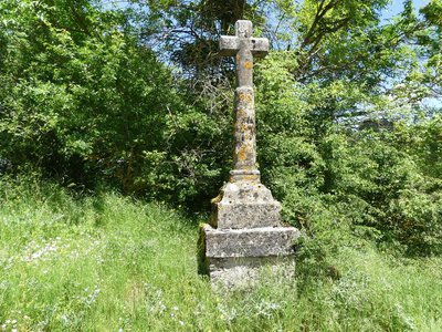
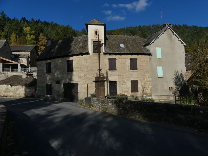
Croix de l'Oustal Crémat - N Thomas HistoryCrosses
This is one of the very many crosses to be found in Lozère, especially in the upper Lot valley. Cross makers, the best known of which is Jean du Born in the 17th century, worked with materials found in the region. For at least six centuries, crosses were erected along paths in Lozère to assume a variety of functions: limit or path markers, memorials, places of contemplation, calvary or pilgrimage site, event, expression of individual or village piety, etc. Over 400 survived the Wars of Religion and then the Terror that followed the French Revolution. The most recent crosses have, since the 19th century, been made of forged iron. Some of them have been fixed on older bases or tree boles.

 Natural environment
A mosaic of environments
Marker 7
The valley landscape unfolds before you, with pride of place given to the fir grove, the jewel of this area. The centenarian grove seduces the walker who is alert to its beauty and unity. The history of the valley continues with forest management that is as concerned with protection and production as ever, but which also increasingly integrates the scenic dimension and welcomes the public – joint preoccupations of the Office National des Forêts and the Cévennes National Park.- History
Foresters' house
The foresters' house of the Loubière valley is located mid-slope, but difficult to see amidst the vegetation. It was first occupied in the 13th century and has been home to the famous De Ligonnès family, one of whom married Marie-Sophie Lamartine, sister of the illustrious poet, in 1827. Since it was bought by the State in 1879, the building has become the private residence of the forest ranger responsible for the sector.
 Geology
Changing backdrops
Marker 6
From one slope to the next, from the valley floor to the ridge, the bedrock changes rapidly. This has repercussions for the soil composition and vegetation, and thereby for the landscape. Thus, opposite you, the limestone cap is occupied by European black pine, which is well-adapted to dry areas. Below that, the schist slope favours natural beech and Scots pine growth, and meets the requirements of the spruces planted by foresters on these deeper soils.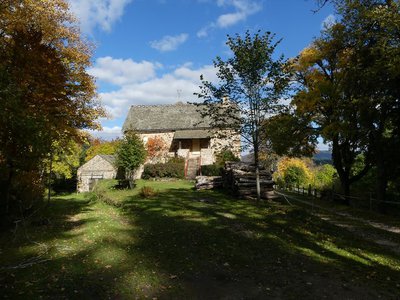
Maison forestière de la Loubière - © Nathalie Thomas HistoryLa Loubière forester’s house
The Château de La Loubière, recorded as far back as 1219, belonged to the barony of Le Tournel. It was originally built here to keep watch over the mediaeval roads going from Florac to Châteauneuf-de-Randon and from Florac to Bagnols-les-Bains. The building, bought by the French state in 1879, has become a forester’s house. It is not open to visitors.
From 1962 to 1964, not far from here, harkis (Muslim Algerian former soldiers in the French army) lived in a camp while working for the French water and forestry service (today the ONF, the French Forestry Office). Twenty-five families with some 30 children lodged there. They contributed to planting the forests that surround you and to maintaining La Loubière forest (which already existed) and the paths that crisscross it.
Description
Signposts will guide you all along this route. In the description below, the signposted place names and/or directions are given in bold italics between quotation marks :
Starting at "Chadenet", walk towards "Le Crouzet" and then :
- « Avenue de la Gare»,
- « Route de la Loubière»,
- « Rue de la Jarretière »,
- « Lou Contrat »,
- « Menhir ». At « L’Oustal Crémat » return to « Chadenet » via :
- « Valat des Pradillous »,
- « Bois de La Loubière »,
- « Col de la Loubière »,
- « Sous le signal de l’Aigle »,
- « Coste del Causse »,
- « Carapasse »,
- « Lou Claoux » .
This hike is taken from the guidebook Mont Lozère – Pays des sources, de la montagne du Goulet aux gorges du Bramont, published by the Pôle de pleine nature du Mont Lozère.
- Departure : Chadenet
- Arrival : Chadenet
- Towns crossed : Chadenet, Mont Lozère et Goulet, and Lanuéjols
Forecast
Altimetric profile
Recommandations
Make sure your equipment is appropriate for the day’s weather conditions. Remember that the weather changes quickly in the mountains. Take enough water, wear sturdy shoes and put on a hat. Please close any gates and barriers behind you.
Information desks

Tourism'house and national Parc at Florac
Place de l'ancienne gare, N106, 48400 Florac-trois-rivières
This office is part of the National Park's associated tourist-information network, whose mission is to provide information on, and raise awareness of, the sites and events as well as the rules that must be observed in the National Park's central zone.
On site: exhibitions, video projections, events and shop Open year-round

Tourism office Coeur de Lozère, Mende
BP 83, place du Foirail, 48000 Mende
This office is part of the National Park's associated tourist-information network, whose mission is to provide information on, and raise awareness of, the sites and events as well as the rules that must be observed in the National Park's central zone.
Open year-round

Tourism office Mont-Lozère, Bagnols-les-Bains
avenue de la gare, 48190 Bagnols-les-Bains Mont-Lozere et Goulet
This office is part of the National Park's associated tourist-information network, whose mission is to provide information on, and raise awareness of, the sites and events as well as the rules that must be observed in the National Park's central zone. Open from mid-April to late September
Transport
Start at Bagnols-les-bains
Bus stop : Bagnols-les-bains, Av du soleil
- Bus line 254 Mende – Villefort – La Garde Guérin.
- Bus line 253 Mende - Bagnols les bains - Mont Lozère.
Access and parking
From Mende, towards Badaroux on the N88, then towards Bagnols-les-Bains on the D901. Well before Bagnols-les-Bains, turn left (D27) to reach Chadenet.
Parking :
Calculateur d'itinéraire Lio
Utilisez le calculateur liO pour organiser votre trajet en région Occitanie.
Autres régions
Calculez votre itinéraire en Auvergne Rhône Alpes sur Oùra
Biodiversité autour de l'itinéraire
Source


Report a problem or an error
If you have found an error on this page or if you have noticed any problems during your hike, please report them to us here: