
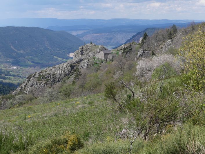
The Bramont gorge
2 points of interest
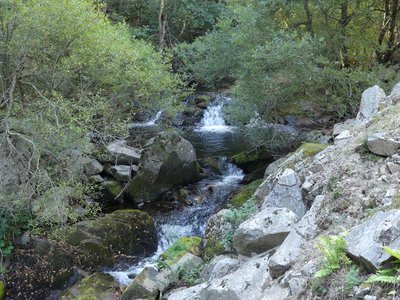
Le Bramont - Nathalie Thomas  Water
WaterThe Bramont river
The Bramont has its spring at Roc des Laubies on Mont Lozère. It runs downhill from there through the gorge which bears its name, crosses the Valdonnez valley and flows into the Lot a few kilometres further on, at Balsièges.
The Bramont is a peculiar river, which is both a major tributary of the Lot and, through underground stream captures, a hidden tributary of the Tarn.
From its spring onwards, the river flows over granite bedrock. But near Les Bondons, on the limestone formation of the Cham (small plateau) of the same name, its water partly disappears in three zones linked to a cave that was explored in about 1987: the Bramont ponor cave. The water re-emerges in Les Combes valley where it creates a waterway also known as the “Bramont”, which becomes a Tarn tributary at Le Cantonnet.
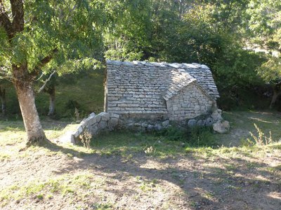
Le moulin de La Fage - Nathalie Thomas  Architecture
La Fage
The hamlet of La Fage has a wealth of ancient architecture and exceptional rural heritage. You can admire:
- its former mill, below the road just before you enter the hamlet;
- the bread oven, with its work room;
- the stall for shoeing cattle;
- the wash house;
- its cross with stoup and granite slab, on which the coffin was placed during funerals;
- the blizzard bell tower, built while waiting for a church that never materialised. The bell formed the pattern of daily life, and on days of powder-snow blizzards, the villagers ran it to help travellers find their way safely to the village.
Description
Signposts will guide you all along this route. In the description below, the signposted place names and/or directions are given in bold italics between quotation marks:
Starting from Saint-Etienne du Valdonnez, at "Mairie" walk towards "Gorges du Bramont".
- At "Gorges du Bramont", go to :
- “Passerelle du Bramont”, then go until
- “La Borie”. From there go down, cross the stream and climb to "La Fage"
- At “La Fage” return to “Saint-Etienne du Valdonnez” via :
- “Bassy”,
- "Chemin de Bassy".
This hike is taken from the guidebook Mont Lozère – Pays des sources, de la montagne du Goulet aux gorges du Bramont, published by the Pôle de pleine nature du Mont Lozère.
- Departure : Saint-Étienne du Valdonnez
- Arrival : Saint-Étienne du Valdonnez
- Towns crossed : Saint-Étienne-du-Valdonnez
Forecast
Altimetric profile
Recommandations
Make sure your equipment is appropriate for the day’s weather conditions. Remember that the weather changes quickly in the mountains. Take enough water, wear sturdy shoes and put on a hat. Please close any gates and barriers behind you.
Information desks

Tourism'house and national Parc at Florac
Place de l'ancienne gare, N106, 48400 Florac-trois-rivières
This office is part of the National Park's associated tourist-information network, whose mission is to provide information on, and raise awareness of, the sites and events as well as the rules that must be observed in the National Park's central zone.
On site: exhibitions, video projections, events and shop Open year-round

Tourism office Coeur de Lozère, Mende
BP 83, place du Foirail, 48000 Mende
This office is part of the National Park's associated tourist-information network, whose mission is to provide information on, and raise awareness of, the sites and events as well as the rules that must be observed in the National Park's central zone.
Open year-round

Tourism office Mont-Lozère, Bagnols-les-Bains
avenue de la gare, 48190 Bagnols-les-Bains Mont-Lozere et Goulet
This office is part of the National Park's associated tourist-information network, whose mission is to provide information on, and raise awareness of, the sites and events as well as the rules that must be observed in the National Park's central zone. Open from mid-April to late September
Transport
Bus stop: Arrêt bus centre
- Bus line 251 "Florac – Mende”. Year-round daily service Monday to Saturday, Attention, bicycles are not allowed
Access and parking
From Mende, towards Balsièges on the N88, then the N 106 towards St-Bauzile, then St-Etienne du Valdonnez (D 125).
From Florac, to the Col de Montmirat on the N 106, then St-Etienne du Valdonnez.
Parking :
Calculateur d'itinéraire Lio
Utilisez le calculateur liO pour organiser votre trajet en région Occitanie.
Autres régions
Calculez votre itinéraire en Auvergne Rhône Alpes sur Oùra
Biodiversité autour de l'itinéraire
Source


Report a problem or an error
If you have found an error on this page or if you have noticed any problems during your hike, please report them to us here: