
Pic de La Tourette
11 points of interest
balisage du parcours - Nathalie Thomas  History
The Jean-Pierre Chabrol literary circuit
Starting at the mairie (town hall), a literary walk takes you through the village of Chamborigaud in the footsteps of local author Jean-Pierre Chabrol (about 5 km, can also be started at the train station).
 History
Pont de Rastel
Pont de Rastel, like Chamborigaud, La Vernarède and Chambon, experienced substantial economic growth during the Golden Age for spinning-mills and coal mines, in the 19th and early 20th centuries. This is the former Le Gravas magnanerie (silkworm farm) to which the writer Jean-Pierre Chabrol, born in Chamborigaud, often referred in his works. It has been the family’s home since the 14th century.
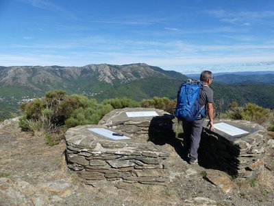
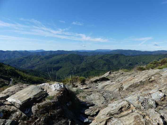
Pic de La Tourette - Nathalie Thomas  Landscape
Pic de la Tourette
At 914m in altitude, this peak offers vast panoramic views over the Cévennes in Lozère and Gard, over the foothills and onto the plains all the way to the coast. Viewpoint indicators await you there.
The summit is also the point where three municipalities meet - Vialas, Ventalons-en-Cévennes and Chamborigaud – and marks the limit between the departments of Lozère and Gard.
- History
Coudoulous
Marker 5
Coudoulous has a squat architecture that is typical of these ridge villages and their mountain climate. It had an inn to accommodate travellers, itinerant shepherds and their flocks, animal-drawn carts, etc. In 1862 Coudoulous had 38 inhabitants in eight houses. Before the Second World War, some 15 people still lived in four of the houses.  Tradition
The day of the fair
“In Coudoulous there was the fair on the first of April, people sold sheep, goats, pigs. It must have taken place until the First World War. For the fair, all the houses were open and used for drinking and eating. There’s a photo of a fair where you can see people dancing in the road. There was also a real inn, the Deleuze Inn. Apparently it used to be a coaching inn, in the days of horse-drawn carts. They stopped there to change horses, from the coaching inn at La Bégude, the next was at L’Espinas. That was...two hundred years ago.”
 Architecture
Verfeuil village
Marker 6
On the rock face you can see traces of tools, showing that the rock was hewn. Below the path, and below the draille, there are pèdes, wall foundations cut into the rock, which reveal the location of a village. The former village cannot be seen in its totality, the area’s topography having changed since the Middle Ages (rockslides, backfilling, construction of terraces for cultivating the land after the village had been built, etc.).- Architecture
Verfeuil castle ruins
Marker 7
The complex of buildings on the summit terrace corresponds to the castle proper. The buildings follow the shape of the rock plinth, which was hewn to provide the foundations of walls built using lime mortar. Having been built with more care than the annexes or the village, they have withstood the ravages of time better.
The staircase giving access to the site, also hewn into the rock, hardly seems damaged at all. It may have been protected by wood. The square man-made holes supported wooden elements whose purpose is unknown. - Architecture
A typical Languedoc castrum
Verfeuil Castle resembles typical Languedoc castra between the 10th and 15th century. Castrum is a mediaeval word for a complex that consisted of a castle and a fortified village. The castle normally had a dwelling, a tower or a keep, and a chapel. The biggest building at Verfeuil Castle was probably a dwelling, but given the lack of excavations, it is not possible to say with certainty what the buildings’ functions were. Nevertheless, the existence of an arms room and a courtyard are known from notarial acts of 1436 and 1446.
- History
From the Grimoards to abandonment
From the 14th century onwards, Verfeuil is mentioned as being the property of the Grimoard family, one of whose members was Pope Urban V. This family also owned the castles of Grizac (Le Pont-de-Montvert) and Bellegarde (St-Privat-de-Vallongue). According to the archives, the order to dismantle Verfeuil was given by the Governor of Languedoc province in 1586, during the religious wars. The site may have been abandoned before then. Castra were frequently deserted from the 14th century onwards in favour of less steep and more comfortable sites.
- Architecture
A defensive site
Marker 8
On either side of the trail, the rock face has been hewn: we are in the inner ditch of the castle. Verfeuil’s role was above all defensive. The castle, built on a rocky spur, blends into the rock, which has been worked to ensure its defence. The only side that is not protected by the natural sheer slope has two parallel ditches cut into the schist. Beyond the outer ditch, traces of the rutted track can be seen. According to the archaeologist Michel Lorblanchet, this castle, like others, may have been built on the site of a protohistoric oppidum (a fortified habitation predating the Roman conquest).  Pastoralism
The draille (drovers' road)
Marker 9
From Coudoulous, the path follows a draille that climbs up from the lowlands via the Château de Portes and joins the draille of Languedoc. Like other ancient routes, drailles are fairly straight and make their way along ridges to passes, avoiding valleys. Two transhumant flocks still make use of this draille today. The dry-stone wall demarcates an old sheep pen used during stops. The manure gathered after the flocks had left enriched crop land on these naturally poor soils. This illustrates how high country and low country complemented each other.
Description
Signposts will guide you all along this route. In the description below, the signposted place names and/or directions are given in bold italics between quotation marks:
Starting at “Chamborigaud”, walk towards “Pont de Rastel” via :
- “Stade", Take the bridge and
- Turn left onto the road and pass Le Martinet then Le Gravas.
- Then walk to the top of “Pic de La Tourette” via :
- “Le Mas Légal”,
- “La Cledasse”,
- “L’Agevol”
- “Sous le pic de La Tourette”. Return to “Pic de Tourette” and walk to “Ruines du château de Verfeuil” via :
- “Coudoulous”. Then continue to “Le Ronc de Donavelle” via :
- “Le Refuge”
- “La Jongle”.
- At “Le Ronc de Donavelle”, return to “Chamborigaud” via :
- “Le Bès”
- “Mairie”.
This hike is taken from the guidebook Mont Lozère - Pays des sources, sommet des Cévennes published by the Pôle de pleine nature du Mont Lozère.
- Departure : Chamborigaud
- Arrival : Chamborigaud
- Towns crossed : Chamborigaud, Génolhac, Vialas, Ventalon en Cévennes, Le Collet-de-Dèze, and Sainte-Cécile-d'Andorge
Forecast
Altimetric profile
Recommandations
Make sure your equipment is appropriate for the day’s weather conditions. Remember that the weather changes quickly in the mountains. Take enough water, wear sturdy shoes and put on a hat. Please close any gates and barriers behind you.
Information desks

Tourism'house and national Parc at Florac
Place de l'ancienne gare, N106, 48400 Florac-trois-rivières
This office is part of the National Park's associated tourist-information network, whose mission is to provide information on, and raise awareness of, the sites and events as well as the rules that must be observed in the National Park's central zone.
On site: exhibitions, video projections, events and shop Open year-round
Tourism'house and national parc, Génolhac
Place du Colombier, 30450 Génolhac
This office is part of the National Park's associated tourist-information network, whose mission is to provide information on, and raise awareness of, the sites and events as well as the rules that must be observed in the National Park's central zone.
Open from april to october

Tourism office Mont-Lozère, Villefort
43, Place du Bosquet, 48800 Villefort
This office is part of the National Park's associated tourist-information network, whose mission is to provide information on, and raise awareness of, the sites and events as well as the rules that must be observed in the National Park's central zone.
Open year-round
Transport
This hike is accessible by public transport.
TER Génolhac – Chamborigaud every day
https://www.thetrainline.com/fr/horaires-train/genolhac-a-chamborigaud
To consult the updated schedules and plan your trip, use the route calculator below by entering the arrival stop: Chamborigaud (Station)
Access and parking
From Génolhac take the D906,towards Pont de Rastel, then to Chamborigaud.
Parking :
Calculateur d'itinéraire Lio
Utilisez le calculateur liO pour organiser votre trajet en région Occitanie.
Autres régions
Calculez votre itinéraire en Auvergne Rhône Alpes sur Oùra
Biodiversité autour de l'itinéraire
Source


Report a problem or an error
If you have found an error on this page or if you have noticed any problems during your hike, please report them to us here: