
Tour du Finiels, MTB circuit #14 (blue)
4 points of interest
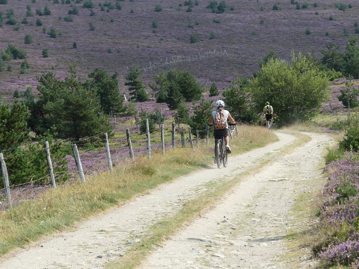
Paysage - © Brigitte Mathieu  Flora
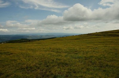
FloraSubalpine short-grass prairie
Marker 1
Like garden or sports pitches, short-grass prairies are shaped by mankind. Grazing and controlled burns are the tools for their maintenance here. The main plants are nard and fescue, perennial grasses related to wheat. If you cut (graze) one of their stalks, five more will soon form; if you trample them, they multiply and become very dense. This kind of “torture” creates a thick plant cover that stabilises the sparse dark soil, which is derived from erosion of the ever-present granite. Here, then, are some clues for the appropriate management of this environment, which becomes weakened if neglected. Flora
FloraOther short-grass prairies?
Marker 7
After the forest, which is a farmed and worked space, foresters clear areas such as here, where other plant communities establish themselves: peat bogs, meadows, track verges. On the return leg, two large grasses will attract your attention: great yellow gentian with its yellow flowers and a more recent arrival, rosebay willowherb (fireweed), whose fruit “explode” into cottony masses at the end of the summer, when ripe. Pastoralism
Down in the valley
Marker 6
The hamlet of Finiels shelters both humans and livestock during the winter. Crop land is subjected to the treatments of modern agriculture. Since the mid-20th century, bovines have slowly replaced sheep and live on fenced-in broom heaths. These pastures are very different from those provided for sheep. Cows do not graze moorland undergrowth.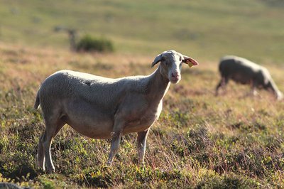
Mouton transhumant, Col de Finiels - © Jean-Pierre Malafosse PastoralismThe sheep reigns
Marker 5
In the late 19th century 100,000 sheep grazed Mont Lozère’s pastures every year. In the summer, there was intense traffic here. In fog, montjoies (standing stones or cairns) still guide travellers, as they did the famous Scottish writer Robert Louis Stevenson and his donkey Modestine. Today, just over 8,000 sheep, divided into flocks each of which is kept by a shepherd, use the summer pastures on the Mont Lozère. They now share the massif’s 6,000 hectares of short-grass prairies and heath with cattle (in pens).
Description
Signposts will guide you all along this route, as well as yellow painted waymarks. In the description below, the signposted place names and/or directions are given in bold italics between quotation marks :
Two possible departure points : D1 (Station du Mont Lozère) or D2 (Col de Finiels pass).
Starting from “Station du Mont Lozère”, D1, go to “Col de Finiels” via :
- “La chapelle du mont Lozère”,
- “Plan des Gours”,
- “Sous le col de Finiels”.
- At “Col de Finiels”, D2, take the path around the Finiels ridge via :
- “Bas du col Plat”,
- “Col Plat”,
- “Font de Sénebébios”,
- “Col de la Draille”,
- “Valat de Mouline”,
- “Route forestière des Crêtes”,
- “Sous le signal des Laubies”. As you arrive at “Sous le signal des Laubies”, turn right onto the track towards “Station du Mont Lozère” via :
- “Route des chômeurs”,
- “Parking des Chômeurs”, “La chapelle du Mont Lozère” and “Station du Mont Lozère”.
This MTB circuit is taken from the guidebook Mont Lozère – Pays des sources, Sommet des Cévennes, published by the Pôle de pleine nature du Mont Lozère.
- Departure : Station du Mont Lozère
- Arrival : Station du Mont Lozère
- Towns crossed : Cubières, Mont Lozère et Goulet, and Pont de Montvert - Sud Mont Lozère
Forecast
Altimetric profile
Recommandations
No off-roading. The summit of Finiels is off limits for bikes; access on foot only.
Caution : There may be livestock guard dogs (patous) in the area. Seek advice on how to behave near these dogs from tourist offices and National Park information centres.
You are strongly encouraged to wear a helmet. Do not forget your repair kit and a small tool kit.
Information desks

Tourism'house and national Parc at Florac
Place de l'ancienne gare, N106, 48400 Florac-trois-rivières
This office is part of the National Park's associated tourist-information network, whose mission is to provide information on, and raise awareness of, the sites and events as well as the rules that must be observed in the National Park's central zone.
On site: exhibitions, video projections, events and shop Open year-round

Office de tourisme Des Cévennes au mont Lozère
le Quai, 48220 Le Pont de Montvert sud mont-Lozère

Tourism office Mont-Lozère, Bagnols-les-Bains
avenue de la gare, 48190 Bagnols-les-Bains Mont-Lozere et Goulet
This office is part of the National Park's associated tourist-information network, whose mission is to provide information on, and raise awareness of, the sites and events as well as the rules that must be observed in the National Park's central zone. Open from mid-April to late September
Transport
Bus stop: Station du Mont Lozère.
- Bus line 261 “Florac – Le Pont de Montvert – Mont Lozère”, every day in July and August
- Bus line 253: Mende - Bagnols les bains - Mont Lozère.
Access and parking
From Le Pont-de-Montvert to Station du Mont-Lozère on the D20.
From Le Bleymard to Station du Mont-Lozère on the D20.
Parking :
Calculateur d'itinéraire Lio
Utilisez le calculateur liO pour organiser votre trajet en région Occitanie.
Autres régions
Calculez votre itinéraire en Auvergne Rhône Alpes sur Oùra
Biodiversité autour de l'itinéraire
Source


Report a problem or an error
If you have found an error on this page or if you have noticed any problems during your hike, please report them to us here: