GR®736 Tarn gorge and valley
This hike between Mont Lozère and the Tarn gorge takes you through diverse landscapes with a wealth of natural heritage and villages with varied and typical architecture based on granite, limestone and schist.
The route is also multi-purpose. Find out how to do part of the circuit by canoe, mountain-bike or e-bike or else with a donkey. Enjoy different ways of discovering the river Tarn using non-motorised means of locomotion !
41 points of interest

 Tradition
The fairs at Villefort
Since 1511, Villefort market has been held on Thursday mornings. In the early 19th century, there were up to 14 fairs a year. Children had to attend mass at Saint-Loup-et-Saint-Roch Chapel to be allowed to go to the fairs. Large crowds were attracted to the fairs by their good reputation. The fair held on 14 September was one of the most impressive, with countless cattle blocking the village's squares and lanes. Today, Villefort is a lively place with bric-a-brac shops and artisan fairs.
 History
The origins of Villefort
In the Middle Ages, Villefort was known as Villa Montisfortis, a name that might stem from a former Roman agricultural estate. At the time, a castle overlooked the village, of which nothing remains today. This castrum was strategically located on the heights of Le Collet (at the southern exit of Villefort) to protect the Regordane Way – and to collect tolls.
- History
The Regordane Way
The Regordane Way linking Alès (Gard) and Luc (Lozère) is a section of the important route that connected Lower Languedoc and the Auvergne in the Middle Ages. It facilitated trade between the Mediterranean basin and parts of the Kingdom of France. The mule-drivers that used it – known locally as Régordans or Rigourdiers – transported oil, wine and salt. It was also a religious path, taking pilgrims called Romieux to Saint Gilles It was progressively abandoned in the 14th century, when the port at Marseille and the fairs in Lyon grew in importance. Ruts left by cartwheels can still be seen north of Prévenchères (between Le Thort and La Molette) and near Saint-André-Capcèze.
 Architecture
Stone architecture
The architecture of Villefort's old buildings is typical for one-street villages:
• the houses with the two vaulted porches were once inns, tradesmen's or artisans' shops: one of the porches was used to store merchandise, the other to display it;
• the sculpted lintels above the entrances to some houses on Rue de l'Eglise and Rue de la Bourgade bear witness to the activities of former occupants;
• several facades have handsome mullioned windows from the Renaissance.- Architecture
Rue de l’Église
The town hall is a former private mansion of the 15th century, with a spiral staircase and ground-floor rooms with vaulted ceilings. The lintel behind the gate comes from a fortified house in the village of Bayard, which is now under the waters of the Lake. On the facade of the 16th century house opposite is a finely crafted mullion window.
• The oldest house in the village is a listed monument and dates from the 14th century. It has Gothic windows and a pulley system once used to bring forage into the loft.
• An archway giving onto an internal courtyard shows you mediaeval walls made from large regular blocks.
• Two lintels bear Christ's monogramme: IHS, Iesus Hominum Salvator (Jesus saviour of mankind). One instance is followed by the inscription Ave Maria. - Agriculture
The sweet chestnut
In 1900, sweet chestnuts were the main farm produce. The nuts of this so-called “bread tree” fed many families as well as their farm animals. Chestnut-growing is a year-round activity, but is especially busy at harvest time. Harvesters would meet in the evening for a brousillade (chestnuts roasted on a wood fire). When parts of the rural population left, many chestnut orchards were abandoned while others were cut down for their tannin to be extracted. Chestnut bleeding canker and chestnut blight, diseases caused by mushrooms, also killed off a great number of trees. Today, chestnut farming in the Cévennes is being revived with a focus on quality.
 Archaeology
Place de l'Ormeau
Villefort's former market square, Place de l'Ormeau hosted Clédou market on Thursday mornings until the 1980s. The square teemed with smells and colours. Livestock, meat, vegetables, grains and chestnuts were sold here, especially in the 19th century. The lime tree on the square was planted on 11 November 1920 as a “victory tree” so that future generations might remember their ancestors' fight for freedom during the First World War. The Maison Chambon, with its double-archway entrance, has an inscribed lintel: Metre Iehan Martin 1595, flanked by a diamond shape and a heart.
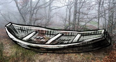
Rocher de la Barque - © Biotope TraditionThe mysterious boat
Have you noticed the strange rock shaped like a boat (barque)? Is that what gave the hamlet its name? Alternatively, in the local patois, a berque is a gap in the mountain. So: Mas de la Barque or Mas de la Berque?
Mas de la Barque is part of the municipality of Vialas and borders the forest of Gourdouze. The estate of the Priory of Gourdouze, to which the forest once belonged, was declared government property during the French Revolution in 1789, before being sold to pay the state’s debts.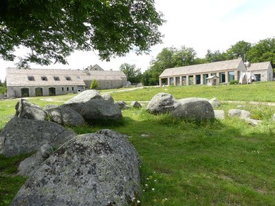
Mas de La Barque - nathalie.thomas HistoryLe Mas de La Barque
Le Mas de La Barque was only a forester’s house at the end of the 20th century. From the 1960s onwards, it was frequented by children’s ski clubs and then by families from the Gard on the weekend. During the week, the association “Union pour l'Animation de la Grange” organised field trips, heritage classes and theme days open to all. A costly infrastructure was gradually built (buildings, ski lifts, snow canons), then partly demolished again. Today, as part of an overall programme of reclassifying the site, it has been developed for tourism (cross-country skiing, snowshoeing, dog-sledding, etc.) and is run by a semi-public company. The resort offers outdoor activities in summer as well as in winter.
Frutgères - nathalie.thomas ArchitectureFrutgères
This village used to be the parish seat and developed long before Le-Pont-de-Montvert, a mere hamlet, turned into a small village of about 60 souls by 1631. In the 12th century, the important Commandery of the Knights of St-John of Jerusalem settled in the parish of Frutgères. This religious and military order later took the name of the Order of the Knights of Malta. The parish church was burned down by the Camisards (Protestant rebels), who were responsible for the assassination of the Frutgères parish priest, Reversat, in 1702, one day after the murder of the Abbot du Chaila in Le-Pont-de-Montvert. The church had been built after the unification of the parishes of Frutgères and Grizac. In the early 19th century, the municipality was densely populated (25 inhabitants/sq km). The large estates needed numerous labourers to harvest their hay, rye and buckwheat.
Le Pont-de-Montvert - © Guy Grégoire HistoryPont-de-Montvert
Marker 12
Le Pont-de-Montvert is at the confluence of the Tarn and two of its tributaries: the Rieumalet and the Martinet. The draille (drovers’ road) has today almost disappeared, but it was once used by flocks from the south of France to reach the summer pastures on the Mont Lozère. The first neighbourhoods were established along this axis. In 1630 the village was almost as extensive as in the early 19th century. Three stone bridges were built over the rivers, but the great floods of 1827 and 1900 seriously damaged or destroyed them. The grand Tarn Bridge is the only stone bridge still standing. New neighbourhoods developed on the village’s periphery, preserving the historic centre.
Chemin des camisards - © Brigitte Mathieu HistoryThe Camisards' path
Marker 11
This path used to be an important communication route linking Le Pont-de-Montvert with Barre-des-Cévennes. On 24 July 1702, it was used by a gathering of Huguenots coming from the Col des Trois Fayards, who intended to liberate their fellow Protestants being held by Abbot du Chayla in Le Pont-de-Montvert. These men thus used the path on which you stand. The tragic events that followed (including the Abbot’s violent death) triggered the Camisard War. The landscape surrounding the village is the result of intense agricultural activity. All neighbouring slopes were cultivated, especially with rye, on man-made terraces called bancels. Geology
A rolling stone...
Marker 10
On the plateau, the path has not always made a very distinct mark on the ground, evidence of little erosion. By contrast, the entire descent towards Le Pont-de-Montvert shows signs of more intense erosion, especially near the top where a large block has rolled into the middle of the path. It is the repeated passage of humans and animals that, combined with natural factors, eventually destabilised the rock. After the rock moved, the path was re-routed.- Architecture
Sheepfold with lauze-covered roof
Marker 9
Unlike the previous sheepfold, this one was built out of heavy, compact and solid materials. A granite vault instead of a timber roof suggests the rarity of wood. The roof was made watertight by schist lauzes (tilestones) on a bed of clay or coarse granite sand. This place is called La Jasse de Chanteloup (jasse/jas: resting place for animals; canteloube in popular etymology = place where the wolves howl, or, according to scholarly sources, luppe = stone, height, rounded mountain).  Landscape
Panorama
Marker 8
Views of the southern slope of Mont Lozère- Architecture
A sheepfold in ruins
Marker 7
You need to leave the path on the left and walk for about 200 metres to see this former shelter for farm animals (ovines and bovines). The materials for its construction were found locally: granite for the walls, Scots pine or oak for the timber part of the roof, rye thatch for the roof. The variety of rye grown locally had fine long straw. It was cut by scythe at the end of July and put into swathes, then stored in stacks and threshed on threshing-floors. Finally it was made into small sheaves, which were soaked before use to make the last seeds germinate and make the straw less breakable during thatching. 
Prairie vers l'Hermet - © Guy Grégoire  Natural environment
Heath alternating with hay meadows
Marker 6
Callune has established itself on the knolls, meaning the convex areas which have poor and dry soils, whereas the meadows occupy the concave areas with their deeper and damper soils. All of these territories offer food sources for specific fauna. You may see hares, but also birds of prey (buzzards, hen and Montagu’s harriers, short-toed snake eagles, common kestrels) and red-legged partridges. Fauna
FaunaPine-forest fauna
Pine forests associated with blueberry zones are interesting environments for fauna: stags and roe deer come to browse the blueberry plants. Wild boar, foxes, martens and all birds eat their berries, including the Western capercaillie, which was reintroduced here by the National Park. You can also find coal tits, European crested tits, wrens, robins, mistle thrushes and black woodpeckers. Some birds of prey, such as the short-toed snake eagle, may come and build their nests at the highest point of a topped Scots pine.
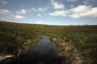
Source du Tarn - © Yannick Manche  Water
WaterThe river Tarn
The Tarn has its spring at an altitude of 1,550 m under the ridge of Mont Lozère. Having carved its way into the granite bedrock, it separates the Bougès massif from Mont Lozère. After Bédouès, it meets the river Tarnon and slowly enters the limestone region, in which its bed is increasingly deep. At its confluence with the Jonte, at Le Rozier, the Tarn leaves the department of the Lozère.
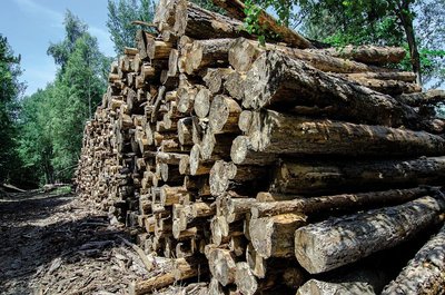
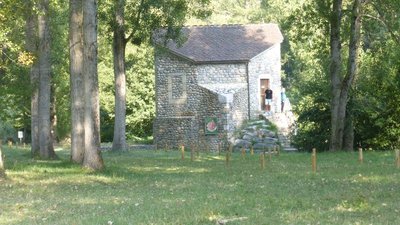
coupe de bois - © Olivier Prohin  Know-how
Fages Sawmill
Upstream from Bédouès, you will see a sawmill, which mainly produces wood to make crates and pallets. It also produces some timber. Today, local forestry companies utilise wood in a number of ways: for energy, paper pulp, timber, crate-making and construction.
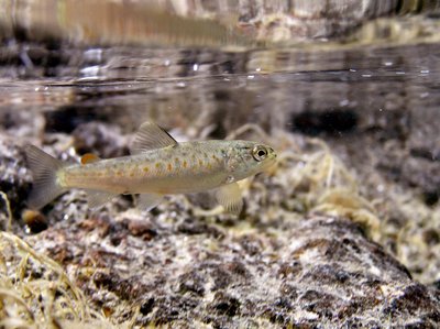
Truite fario - © Philippe Baffie FaunaThe brown trout (Salmo trutta fario)
This trout lives in our waterways and is an indigenous species. This stock is a part of our heritage. Its size varies with the quality of the water, fishing pressures, and the nature of the riverbed (hiding-places). In the summer, it hunts in white water and on the surface, and catches insects. In the winter, it eats larvae on the bottom. Reproduction begins in November and is staggered throughout the winter. The female lays its eggs on a gravelly stretch of the riverbed, into which it has dug a pit using its caudal fin. The male deposits its milt over the eggs. Once they are fertilised, the eggs are covered with gravel. Reproductive success depends on variations in the water flow and especially on the risk of the spawning areas drying out in dry winters.
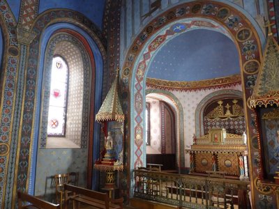
Chapelle St-Saturnin - © Nathalie Thomas HistorySaint-Saturnin chapel
Saint-Saturnin chapel stands at the heart of the village, surrounded by its cemetery. Inside every wall boasts a magnificent painted décor. It was built in the 12th century. Guillaume de Grimoard (the future Pope Urban V) was baptised here in 1309. It is next to the town hall (mairie) and is well worth a detour.
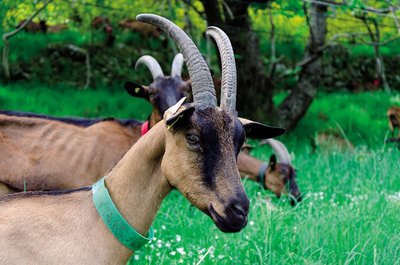
Chèvre de race alpine - © Olivier Prohin AgricultureThe Gautier goat farm
Yolande and Christian run a small farm where they make farmhouse goat's cheese, a typically Cévenol product. Their herd consists of 60 Alpine dairy goats, and all their milk is processed on-site into farmhouse cheese. From late November to late April, the nanny goats have a break so their little ones can feed!
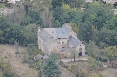
Château d'Arigès - © com com Florac Sud Lozère HistoryChâteau d’Arigès
This can be seen on your left, in a gap in the forest. It was only a share-cropping farm, whose buildings were in ruins, when the Lord of Issenges bought it in 1658. He lived in it from 1688. This Château, which is no doubt more comfortable than the « maison carrée » (“square house”), was built in a river bend of the Tarn and is surrounded by fertile soils well-suited for crop-growing.
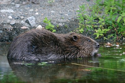
Castor au réfectoire - © Bruno Descaves FaunaThe European beaver (Castor fiber)
The calm deep stretches of the Tarn are good areas to settle for the European beaver, which lives in a lodge dug into the river bank. An essentially vegetarian animal, it bases its diet on cellulose. It eats young shoots, bark, aquatic plants, and foliage that is abundant in the riparian forest. It is thus useful in regulating the woody vegetation of river banks, facilitating the development of riverside fauna and flora. Through its activities, it prevents the potentially dangerous accumulation of dead wood during floods. It does not build dams.
- Geology
The iron-rich water of Salce
After a small detour from the hamlet of
Salièges to the river Tarn, you will come across a spring of ferruginous water. For a long time, the ability to prevent (or cure) alcoholism was attributed to this water rich in Fe2+ ions, and made famous by a sketch by the stand-up comedian Bourvil. It supposedly supplies the iron that would normally come from regularly drinking alcohol. A small construction indicates the Salce spring (the path from Salièges is way-marked), as does the red tinting from iron oxide, which you find in many contact zones between schist and limestone. 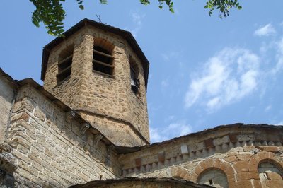
Chevet de l'église d'Ispagnac - cevennes-gorges-du-tarn ArchitectureIspagnac church
St-Peter’s Church in Ispagnac is one of the finest examples of Romanesque architecture in Gévaudan. Built in the 12th century, it is dedicated to Saint Peter and Saint Paul. The understated facade of this bulky-looking building has a simple gate with three semi-circular arches topped by a rose window that lets light into the nave. Once inside, you discover a simple and airy architecture. A sound-and-light show helps you to explore. To get the fullest impression of the architecture, you need to leave the building and walk around it to see the apse and its décor.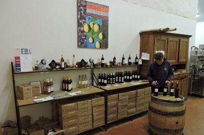
La cave viticole d'Ispagnac - cevennes-gorges-du-tarn AgricultureThe vintners of Ispagnac
In 2003, Sylvain Gachet, from Savoy, reintroduced grapevines to Ispagnac and Florac, planting six hectares of terraced land. On soils of clay/limestone and schist, he attempted to breathe new life into the Domaine de Gabalie. In 2006, Elisabeth Boyé and Bertrand Servières set up as vintners in the Tarn gorge, also under the stimulus package bringing vineyards back to the valley. They cleared the land of the bartas (brambles) which had invaded almost all the parcels, and rebuilt the dry-stone walls before planting almond trees, vine peaches and five hectares of grapevines: the Domaine des Cabridelles was born. The winemakers share a cooperative cellar in Ispagnac, which is also a sales outlet. Why not make a short stop to try the wines (the cellar is next to the car park by the state school (école publique).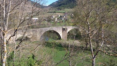
Pont de Quézac - © CC Florac Sud Lozère ArchitectureQuézac Bridge
This bridge crossing the river Tarn gives access to the village of Quézac, located on the left bank. Around 1350, Pope Urban V decided to fund its construction to facilitate pilgrims' access to the collegiate church of Notre-Dame de Quézac. It was finished in the 15th century. Its history is punctuated by partial destruction in floods, and by more or less solid rebuilding. It became a listed monument on 27 August 1931.
Source de Quézac - © Nathalie Thomas WaterQuézac mineral water
Quézac mineral water emerges naturally from the Diva spring, near the entrance to the village, in exceptional surroundings which have been naturally protected for centuries. This pleasant-tasting water is rich in mineral salts and trace elements and is also well-known to be beneficial for the stomach. The spring's water actually comes from Mont Aigoual. According to scientific studies, it takes 30 to 40 years for it to re-emerge in Quézac, after first settling in aquifers, where it acquires its effervescence naturally (rare in France).
Château de Charbonnières. - © OTGCC nc ArchitectureThe Château de Charbonnières
In a bend of the Tarn downstream from the village of Montbrun stands the Château de Charbonnières. While the former castel has lost some of its defensive elements, it has nevertheless preserved a knightly characterand traces of many historical episodes of the Tarn valley. It is first recorded in the 13th century. Its defensive role was tightly linked to a whole “fortified system” downstream of Ispagnac, which consisted of Quézac, Javillet, La Roche, Rocheblave, Montbrun, Castelbouc, Prades and Sainte-Enimie.
The château has three rectangular //buildings arranged in a horseshoe shape around an internal courtyard. The facade overlooking the Tarn has a square tower that dominates the river. Access to the internal courtyard is via gates under a semi-circular arch. From the courtyard, a stone staircase leads up to the chapel, whose doorways is decorated with fleur-de-lys. The modest interior has a ribbed vault framing a keystone engraved with the arms of the Montesquiou family, lords of Charbonnières from the 13th century onwards. The other parts of the residential building have handsome fireplaces, a monumental staircase and fine vaulted halls. In the 17th and 18th centuries, the château became the property of the Volonzac Malespina family and, in the 19th century, of the Boutin family. It is not open to the public.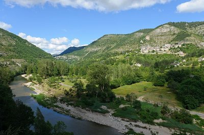
Les gorges du Tarn et le village de Montbrun - BOUISSOU Arnaud / TERRA Ministère de l'Environnement WaterNot always a docile river!
For 52 km, from the point it enters the canyon at Quézac to Le Rozier, the Tarn has no overground tributary. However, it is fed by about 170 karst springs stemming from subterranean aquifer networks. These springs release the rainwater absorbed by the avens, dolines and fissures of the Causses plateaux. When reserves are high, the water gushes with great force from the karst environment. Locals say that “the corks are popping”. In the event that the tributaries of the Tarn (the Mimente and Tarnon) rise and add to the springs, the time will have come to move the furniture upstairs.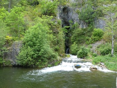
Résurgence de Castelbouc - © N Thomas WaterThe spring of Castelbouc
The vast spring as you enter the hamlet has four outlets, including one at the back. These openings, out of which water surges during heavy rain, reinforce the translation of the Occitan bouc as bouches (“mouths”). All springs are fed by a catchment area of varying size. Here, the catchment area is the sector of Aven du Pic de l’Usclat, Aven du Loup (Cros garnon) and Aven du Crapaud (Fretma) on the Causse Méjean plateau.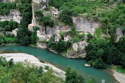
Castelbouc - B Daversin HistoryThe strange legend of Castelbouc
For you to judge…
The etymology of Castelbouc is castel blanc, meaning “perched on the rock” in Occitan.
Legend has it that during the Crusades the castle’s lord was the only man to have remained behind in this little hamlet of dwellings built against the cliff. He had many female visitors, and it was important to him to satisfy their needs. Unfortunately, the Crusade was so long that he was unable to keep going to its end. When his soul left his body, an enormous he-goat was seen hovering over the castle tower… Ever since, a bleating sound followed by strange murmurings can be heard on the summit. This is the legendary origin of the name of Castelbouc...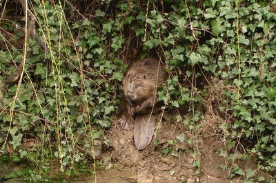
Castor - © OTGCC nc FaunaThe beaver
Proof that I have been here might be a tree carved into a pencil shape; pieces of bark; wood chips; a heap of branches in the water; back or front paw prints in the sand. I’m the Eurasian beaver. I live near water. I’m active mostly at night, and sometimes at dawn and dusk if no-one disturbs me. From the Middle Ages (11th century) to the 19th century, times were hard for us. We were hunted by humans for our flesh, fur and because we were thought a nuisance. In the early 20th century, we had disappeared from many parts of France. Today, things are better – we live alongside and in the Tarn again.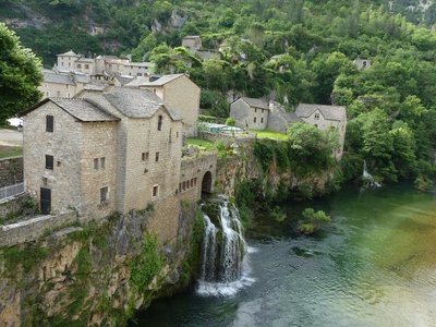
Saint-Chély du Tarn - nathalie.thomas HistorySaint-Chély du Tarn
Saint-Chély-du-Tarn benefits from the three ideal conditions for founding a village: ample springs; construction materials (tuff rock) available on site; and, above all, a track connecting it to the Causse Méjean plateau. All the gorge hamlets are linked to the Causse by a path. Over time, these connecting paths were developed to varying extents – cobbled and/or consolidated by small walls – and they facilitated trade.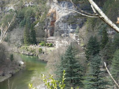
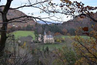
Le château de La Caze - nathalie.thomas HistoryThe Château de La Caze
The Château was built in 1489 as a wedding present for Soubeyrane d'Alaman, the niece of the Prior of Sainte-Enimie. With its four corner towers, it is now a hotel. Tradition tells a ribald story about the eight daughters of a former owner. Beautiful and mischievous, they believed in smooth talking and free love. It is said that “their souls are condemned to wander and sigh all night in this dark gorge for want of satisfaction".
Hauterives - nathalie.thomas HistoryHauterives
This hamlet was built in an amphitheatre shape above the (now ruined) mill so as to save on farm land. The mill would have been a convivial spot and the fundamental economic link between the plateau and the valley. Here the plateau’s grains were exchanged for legumes, grapes and almonds grown on the well-sited terraces that are still visible today. The mill and dam were carried off by the once-in-a-century flood of 1900. When the road was opened in 1905, Hauterives refused permission for the construction of a bridge. Currently a cable car makes it possible to transport goods and other objects. Access for inhabitants is by boat.
Gorges du Tarn - © Guy Grégoire HistoryThe boatmen of La Malène
“La Malène” means “bad hole”... But for several decades now, it has been more accurate to call it a little jewel that delights tourists. What is its secret? Using the boats which were once strictly utilitarian, back in the days when the Tarn was a transport and trade route! On 29 December 1952, the Cooperative Society of Boatmen of the Gorges du Tarn was officially created. In 1985, the Cooperative became a Worker Cooperative. Once on the water, the boatmen will help you discover sites that can only be seen and approached by boat, such as La Momie Cave, or the Woman with a Parasolrock formation above La Croze. That's at least two good reasons to treat yourself to this journey by water accompanied by the boatmen of La Malène.
- History
Little anecdote
"Traditionally, a hillclimbing race is held in this small town on the first Sunday in July. The first races were goat races. Marthe marshalled her goats at the bridge, climbed the slope of La Canourgue by herself and then called to them from up there. The goats ran to her. The winner was rewarded with a fragrant bouquet of bartas (box)." (M.P Leroy-Delmer)
- History
Chapel
"300 m from the hamlet, the ruins of the Château de Planiol dominate a flat area (planiol) of the river, which is 8 m deep here. Then the Romanesque 12th century chapel appears, probably built on the site of a Carolingian oratory. An 'expiatory chapel' has been added, which contains the remains of the martyrs of La Malène. Another chapel is occupied by the Virgin Mary standing in a boat. It is brought out every May for the boatmen's pilgrimage. As for the bridge, it was built in 1856 in the place of a former ford crossed by the Esperelle draille (path for seasonal livestock migration). Because of its scant height, it did not survive the devastating floods of 1875 and 1900.” (M.P Leroy-Delmer)
Description
Only the section of the GR® long-distance hiking path that crosses the Cévennes National Park (from Villefort to Le Rozier) is presented here.
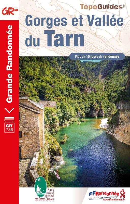
The official guidebook for the GR®736 by the Fédération Française de randonnée pédestre (FFRandonnée, French hiking federation) has been published in spring 2023. You can find it on sale in the Maisons du tourism et du Parc (joint tourist office and National Park information centres), the online shop at www.cevennes-parcnational.fr, in bookshops and sports shops and at https://boutique.ffrandonnee.fr
- Departure : Villefort
- Arrival : Le Rozier
- Towns crossed : Villefort, Pourcharesses, Saint-André-Capcèze, Ponteils-et-Brésis, Concoules, Pont de Montvert - Sud Mont Lozère, Vialas, Cassagnas, Cans et Cévennes, Florac Trois Rivières, Bédouès-Cocurès, Gorges du Tarn Causses, Ispagnac, La Malène, Massegros Causses Gorges, Saint-Pierre-des-Tripiers, and Le Rozier
Forecast
Altimetric profile
Recommandations
NB: For a variety of reasons, there may be differences between the actual waymarks and the route shown in the guidebook.
Please follow the waymarks.
Make sure your equipment is appropriate for a multi-day hike as well as for the day’s weather conditions. Remember that the weather changes quickly in the mountains. Take enough water, wear sturdy shoes and put on a hat. Please close any gates and barriers behind you.
Bivouacking in the Cévennes National Park is regulated. Get informed at La Maison du tourisme et du Parc (joint tourist office and National Park information centre) in Florac-Trois-Rivières (tel. 04 66 45 01 14).
Information desks

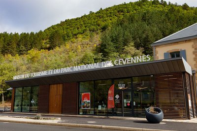
Tourism'house and national Parc at Florac
Place de l'ancienne gare, N106, 48400 Florac-trois-rivières
This office is part of the National Park's associated tourist-information network, whose mission is to provide information on, and raise awareness of, the sites and events as well as the rules that must be observed in the National Park's central zone.
On site: exhibitions, video projections, events and shop Open year-round

Office de tourisme Des Cévennes au mont Lozère
le Quai, 48220 Le Pont de Montvert sud mont-Lozère

Tourism office Mont-Lozère, Villefort
43, Place du Bosquet, 48800 Villefort
This office is part of the National Park's associated tourist-information network, whose mission is to provide information on, and raise awareness of, the sites and events as well as the rules that must be observed in the National Park's central zone.
Open year-round
Transport
Summer only bus lines
- line 254 La Garde Guérin - Villefort - Bagnols les bains - Mende
- line 253 Mende - Bagnols les bains - Mont Lozère
- line 261 Mont Lozère - Pont de Montvert - Florac
- line 258 Florac - Le Rozier
Access and parking
Villefort on the D906 from Génolhac or on the D901 via Le Bleymard.
Parking :
Calculateur d'itinéraire Lio
Utilisez le calculateur liO pour organiser votre trajet en région Occitanie.
Autres régions
Calculez votre itinéraire en Auvergne Rhône Alpes sur Oùra
Biodiversité autour de l'itinéraire
Source


Report a problem or an error
If you have found an error on this page or if you have noticed any problems during your hike, please report them to us here: