Causse du Masseguin
4 points of interest
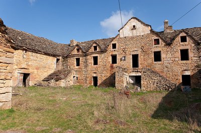
Village de Masseguin - © Nathalie Thomas  Architecture
Le Masseguin
“This hamlet contains a few handsome examples of traditional architecture and an unusual joint fountain-bread oven. The back wall of the fountain was added later, and the layout of the buildings shows that the ruined oven, which is behind the fountain, was originally covered by the same roof.” (A. Boemare)
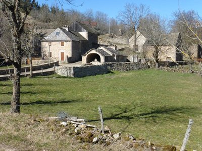
Ancienne ferme fortifiée de Chapieu - © Guy Grégoire ArchitectureChapieu farm
"These buildings, which were the headquarters of a very large Causse farm, are laid out around a central courtyard. The main building faces south and consists of two floors of living quarters above a sheepfold. Two barns under vaulted granges that are 22 m long form the wings.” (A. Boemare)
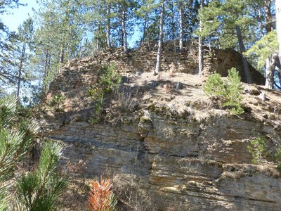
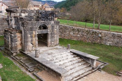
Château de Chapieu - © Nathalie Thomas  History
Château de Chapieu
"This château is the oldest in the Tournel barony. The Chapieu site is a diverticulum of the Causse de Mende, with steep slopes on three sides. To defend it, one simply had to bar the passage linking it to the plateau. It is likely that an oppidum preceded the castle from the Iron Age onwards. (…) Was it finally razed to the ground on Richelieu's orders, like so many others? In any case, it is nothing but ruins from the 17th century on.” (A. Boemare)
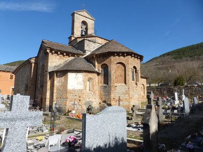
Église de St-Pierre - © Nathalie Thomas ArchitectureSt-Pierre Church
"St-Pierre Romanesque church was built in the 12th century and expanded in the 14th. Built from tuff and limestone from the region, it has remained very pure in style. The nave has a barrel vault; two chapels added in the 14th century make up the side aisle. They house the funerary niches of the Auriac, Châteauneuf and Tournel families. The transept, which is topped by a dome on squinches, supported an octagonal bell tower before the French Revolution. The five-sided apse and the apse chapels are covered by spherical vaults: from the outside, they form a beautifully arranged chevet.” (A. Boemare)
Description
Signposts will guide you all along this route, as well as yellow painted waymarks. In the description below, the signposted place names and/or directions are given in bold italics between quotation marks :
Starting at “LANUÉJOLS”, walk to “Eglise” then :
- “La Coste”. At “La Coste”, go right towards :
- “Vitrolles”. At “Vitrolles”, continue straight ahead to :
- “Combe Sourde”. At “Combe Sourde”, go right towards :
- “Le Masseguin”. At “Le Masseguin”, continue straight ahead to :
- “Sous le Col de la Loubière”. At “Sous le Col de la Loubière”, go left to :
- “Col de la Loubière 2x”. At “Col de la Loubière”, walk to :
- “Ron des Classes”. At “Ron des Classes”, continue straight ahead to “CHAPIEU” via :
- “Plot de la Coste”,
- “La Valette”.
- At “CHAPIEU”, turn left to return to “LANUÉJOLS” via :
- “Vieux Chapieu”,
- “Condamine”,
- “Lou Martoulet”.
This hike is taken from the guidebook Mont Lozère – Pays des sources, de la montagne du Goulet aux gorges du Bramont, published by the Pôle de pleine nature du Mont Lozère.
- Departure : Lanuéjols
- Arrival : Lanuéjols
- Towns crossed : Lanuéjols, Chadenet, Sainte-Hélène, and Badaroux
Forecast
Altimetric profile
Recommandations
Make sure your equipment is appropriate for the day’s weather conditions. Remember that the weather changes quickly in the mountains. Take enough water, wear sturdy shoes and put on a hat. Please close any gates and barriers behind you.
Information desks
Tourism office Coeur de Lozère, Mende
BP 83, place du Foirail, 48000 Mende
This office is part of the National Park's associated tourist-information network, whose mission is to provide information on, and raise awareness of, the sites and events as well as the rules that must be observed in the National Park's central zone.
Open year-round

Tourism office Mont-Lozère, Bagnols-les-Bains
avenue de la gare, 48190 Bagnols-les-Bains Mont-Lozere et Goulet
This office is part of the National Park's associated tourist-information network, whose mission is to provide information on, and raise awareness of, the sites and events as well as the rules that must be observed in the National Park's central zone. Open from mid-April to late September

Tourism office Mont-Lozère, Villefort
43, Place du Bosquet, 48800 Villefort
This office is part of the National Park's associated tourist-information network, whose mission is to provide information on, and raise awareness of, the sites and events as well as the rules that must be observed in the National Park's central zone.
Open year-round
Access and parking
From Mende to Balsièges (N88), then take the N106 towards Col de Montmirat (from Florac, N106 towards Mende-Col de Montmirat). At Rouffiac take the D41 to Langlade, Lanuéjols.
From Le Bleymard, towards Mende (D901). At Bagnols-les-Bains take the D41 to Lanuéjols.
Parking :
Calculateur d'itinéraire Lio
Utilisez le calculateur liO pour organiser votre trajet en région Occitanie.
Autres régions
Calculez votre itinéraire en Auvergne Rhône Alpes sur Oùra
Biodiversité autour de l'itinéraire
Source


Report a problem or an error
If you have found an error on this page or if you have noticed any problems during your hike, please report them to us here: