
The dolmens of La Grande Pallières
The site of La Grande Pallière is considered the largest prehistoric necropolis in acidic soil. This path is enlivened by panels made in collaboration with Florian Secondary School.
Happy exploring !
3 points of interest
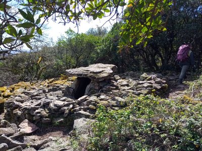
Dolmen de la Grande Pallières - N Thomas  Archaeology
Dolmens at La Grande Pallières
This site is considered the largest prehistoric necropolis in acidic soil.
All the dolmens are different and have been dated to the late Neolithic (3,500 years BCE). They were reused as collective burial sites until the late Bronze Age (800 years BCE).
More information can be found on the small panels conceived with Florian Secondary School.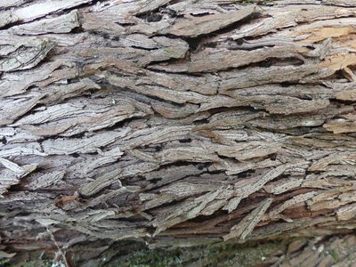
L'écorce de l'Arbousier - N Thomas  Natural environment
The strawberry tree
This was a sacred plant for the Romans: the goddess Cardea is said to have used it to keep away witches.
This bush flowers in winter and bears fruit the following year. In autumn, you can therefore see both flowers and fruit on the same tree.
Its trunk has fine cracks, and its foliage is evergreen.Its branches become crooked with age, and the trunk can be spiral-shaped.
During your walk, you will see some very handsome specimens !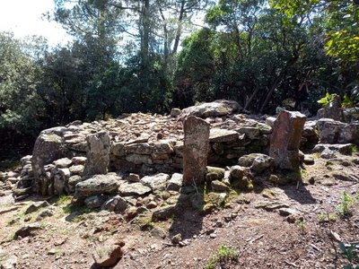
Dolmen de Panissière - N Thomas ArchaeologyDolmen de Panissière
"Located at an altitude of 420m not far from a former sheepfold, this dolmen was constructed out of coarse sandstone. It was searched and restored in the late 1980s by the Groupe Alésien de Recherche Archéologique. It has a corridor, is 7m in diametre and is enclosed in a tumulus delimited by 17 monoliths 80cm to 130cm in length. These are single large stones, either natural or carved” (text extract from panel on site).
To read more, go to the dolmen !
Description
Signposts will guide you all along this route. In the description below, the signposted place names and/or directions are given in bold italics between quotation marks:
Start at “L’Aiguille” car park, above Driolle.
- Walk to “Panissière”.
- Take the path uphill to “Col de Panissières”.
- Continue to “Dolmens de la grande Pallières”.
- Take the ridge path and go downhill to “Dolmen de Panissière”.
- Continue downhill to “Sous le Dolmen”.
- Walk to “Les croix de Pallières” x2.
- Go downhill to “Panissière”.
- Return to “L’Aiguille”.
- Departure : L’Aiguille (Anduze)
- Arrival : L’Aiguille (Anduze)
- Towns crossed : Anduze and Thoiras
Forecast
Altimetric profile
Recommandations
Make sure your equipment is appropriate for the day’s weather conditions. Remember that the weather changes quickly in the mountains. Take enough water, wear sturdy shoes and put on a hat.
Information desks

Tourism'house and national Parc at Florac
Place de l'ancienne gare, N106, 48400 Florac-trois-rivières
This office is part of the National Park's associated tourist-information network, whose mission is to provide information on, and raise awareness of, the sites and events as well as the rules that must be observed in the National Park's central zone.
On site: exhibitions, video projections, events and shop Open year-round
Tourism office Cévennes Tourisme, Anduze
Plan de Brie, 30140 Anduze
This office is part of the National Park's associated tourist-information network, whose mission is to provide information on, and raise awareness of, the sites and events as well as the rules that must be observed in the National Park's central zone. :
Open year-round
Access and parking
From the centre of Anduze, take the D907 towards St-Jean du Gard for 2 km, to the roundabout. At the roundabout, turn left to Driolle, via the light industrial area, then on Voie de l’Olivier. Continue on Chemin de l’Olivier, then Chemin de la Grande Pallière, and Panissière.
NB : Do not go downhill to Driolle but stop by the departure sign for the Sentier du Dolmen trail.
Parking :
Calculateur d'itinéraire Lio
Utilisez le calculateur liO pour organiser votre trajet en région Occitanie.
Autres régions
Calculez votre itinéraire en Auvergne Rhône Alpes sur Oùra
Biodiversité autour de l'itinéraire
Source

Report a problem or an error
If you have found an error on this page or if you have noticed any problems during your hike, please report them to us here: