
Saint-Pons hermitage
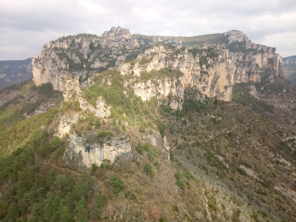
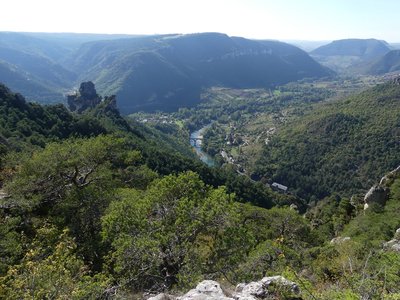
This unique loop captivates immediately, with a techical climb to Capluc, from where a path takes you to the Saint-Pons site, at the foot of the astonishingly shaped rocks sloping up to the Causse Méjean. On the Jonte side, the landscape is a treat for your eyes but be careful where you put your feet at the edge of the truly vertiginous cliffs.
5 points of interest
Vallée du Tarn - N Thomas  History
Le Rozier
The village of Le Rozier (formerly called Entraygues, meaning between the waters) lies at the confluence of the Tarn and the Jonte. According to Philippe Chambon, “on 12 July 1075, Déodat de Canilhac, Raimond de Mostuéjouls and Bernat de Peirelau left to the abbey of Aniane the plots of land belonging to their respective seigneuries located where the current village stands”.
For some, the name of the village comes from the name of the parcel of land on which the priory of Saint-Sauveur was built, the “Camp de Rosario”; for others, it has its origins in an Asian rose variety introduced and grown here by the monks (…)
The human presence at the Le Rozier site is ancient: in the Gallo-Roman era, a pottery workshop existed at the confluence of the two rivers. Its ceramics were similar to those of Graufessenque (Millau).
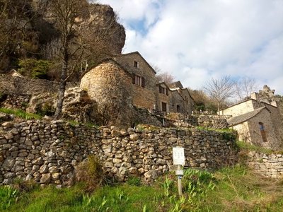
Capluc - NT HistoryCapluc
Capluc was once a defensive and surveillance site, with a castle that (like many of the village’s houses) no longer exists. Some of the houses were renovated once a track suitable for motor vehicles was opened to the hamlet. The name Capluc is believed to come from cap and luz, meaning head and light, thus symbolising the place illuminated by the first rays of the rising sun.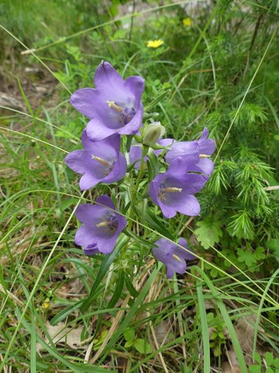
Campanule à grandes fleurs - N Thomas  Flora
FloraAn adapted flora
As Jean-Paul Salasse explains, “Rocks are highly selective environments: no soil, strong sun exposure, drought, often violent winds, vast temperature differences between day and night and summer and winter. That is why montane or alpine plants establish themselves here, even at low altitudes, having managed to adapt to these difficult conditions : solid roots, often fleshy leaves, large flowers” (Guide Gallimard, Parc national des Cévennes).
You may see certain bird species (golden eagle, blue rock thrush, wallcreeper, etc.) and plant species (Pyrenean bellflower, daphne alpina, alpine balsam) that are perfectly adapted to this peculiar and very specific environment.
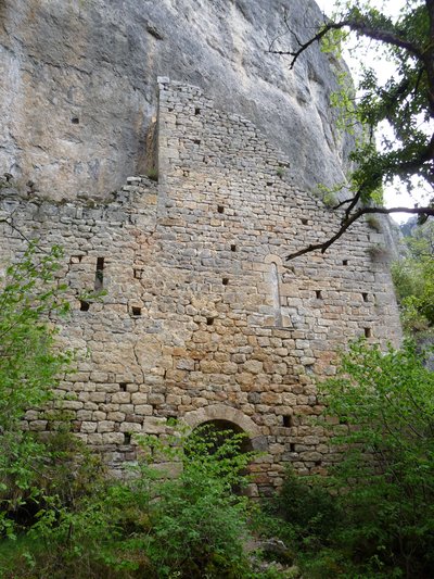
Ermitage Saint-Pons - N Thomas HistoryHermitage Saint-Pons
It is highly likely that the word “hermitage” is not a correct description of Saint-Pons. These few stretches of wall rather indicate a fortified keep, built in the Middle Ages. They were legion throughout the Tarn and Jonte gorges. Since myths die hard, a pilgrimage was organised until the early 20th century to heal deformed children.
Despite the wear and tear of time, you can see walls made from shaped stone, a doorway with a recessed arch on piers and two small windows.
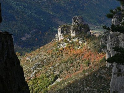
Capluc et son rocher - NT AgricultureCapluc and its terraces
As you leave Capluc, you become aware of how the site, which at first sight seems barren, has in fact been shaped by humans. All of this south-facing slope, which is protected by the tall dolomite cliffs, was farmed using terraces (grains, fruit trees, grapevines). Temperatures are so favourable that the most southern Mediterranean vegetation of the region grows here (narrow-leaved ash, jasmine, Montpellier maple, holm oak, etc.).
Description
1- Walk along the main road towards Meyrueis. Before the fish farm, take on the left the ten or so steps uphill between the houses and continue on the path until it comes out onto a hairpin bend in the road. Take the path uphill on your right. At the second hairpin bend, take first the road, then the concreted uphill section. Turn left onto the Roman road to reach the centre of Capluc. Walk through the hamlet along its narrow lanes. After some steps, you join a well-marked path opposite a ruined façade (not part of the loop: Rocher de Capluc, see The Cliffs of the Causse Méjean walk).
2- Take this path on the right for 20 m and, just before a bread oven, go left. Walk past ruined houses to reach the ridge, cross over into the Tarn valley and walk upriver along the foot of the cliffs. Just before the path enters a cave, it passes through some ruined buildings, with only a few stons remaining on the ground. As you exit the cave, you are on the Saint-Pons site.
3- After Saint-Pons, the path climbs. It passes under a stone arch, then climbs in hairpin bends to come out onto a larger path. Turn right onto this. The path passes near Le Teil spring (there-and-back, 80m).
4- Continue to the Col de Francbouteille pass, where you will leave the Tarn valley to return to the Jonte valley.
5- At the crossroads 150 m further down, continue downhill to the Ravin des Échos ravine. This path will take you back to the hamlet of Capluc.
6- After the relay mast, take the path on the right, which is also waymarked as a GR®. As you arrive at the road, turn left and stay on the pavement till you reach the car park.
- Departure : Le Rozier
- Arrival : Le Rozier
- Towns crossed : Le Rozier and Saint-Pierre-des-Tripiers
Forecast
Altimetric profile
Recommandations
Make sure your equipment is appropriate for the day’s weather conditions. Remember that the weather changes quickly in the mountains. Take enough water, wear sturdy shoes and put on a hat.
Information desks

Tourism'house and national Parc at Florac
Place de l'ancienne gare, N106, 48400 Florac-trois-rivières
This office is part of the National Park's associated tourist-information network, whose mission is to provide information on, and raise awareness of, the sites and events as well as the rules that must be observed in the National Park's central zone.
On site: exhibitions, video projections, events and shop Open year-round
Access and parking
LE ROZIER : 30 minutes from Meyrueis on the D996, Route de la Jonte
Parking :
Calculateur d'itinéraire Lio
Utilisez le calculateur liO pour organiser votre trajet en région Occitanie.
Autres régions
Calculez votre itinéraire en Auvergne Rhône Alpes sur Oùra
Biodiversité autour de l'itinéraire
Source

Report a problem or an error
If you have found an error on this page or if you have noticed any problems during your hike, please report them to us here: