
Coudoulous trail
The Coudoulous trail offers magnificent panoramic views onto the Longue and Cézarenque valleys from the mountain ridges, which seem uninhabited by mankind. And yet, in places the schist is worn, carved, cut or worked. Here, you follow a rutted track; there, you decipher mysterious carvings; elsewhere, you can guess at the ruins of a mediaeval castle. Around the corner from the trail, the landscape yields up its secret history in the steps of the humans who shaped it.
13 points of interest
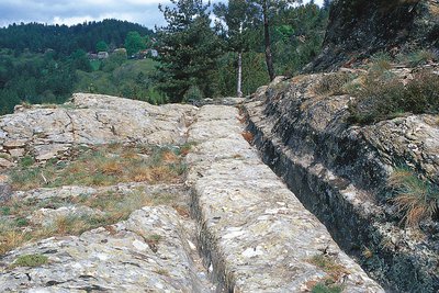
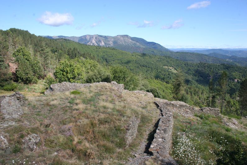
Ornière de Coudoulous - © Guy Grégoire  History
Rutted track
Marker 1
Deep ruts cut into the surface of what seems to be one of the oldest communication routes in the Cévennes. They are caused by the iron-bound wheels of animal-drawn carts wearing down the schist. The constant spacing of the ruts, about 1.45m apart; the high-up location of the track above any springs (thus avoiding the need to build bridges); and its fairly straight course confirm that this is an ancient road. There are blocks of quartz in the ruts that have resisted wear, proving that the ruts were not hewn. But it is possible that a mini-rut was deliberately cut into the rock to act as a rail, so as to prevent vehicles from swerving. To reduce the depth of the ruts, they may have been levelled with backfill. History
Mysterious carvings
Marker 2
About ten inscriptions have been inventoried on the hewn rock face bordering the track. They seem to have no grammatical connection. Some see in them Gaulish or Roman names (MARCUS, LAIS, VETURIX or VIITURIX), which would suggest that the track has its origin in Antiquity, though this is impossible to prove as yet. The nearby discovery of a Roman coin from Nîmes only attests that people passed through here in Antiquity. This graffiti could just as well be the work of shepherds looking after their flocks much more recently! Landscape
The landscape
Marker 3
The panorama looks out over the Herm valley. The hamlets, built on ledges at the level of the springs, are surrounded by terraces of crop land. They are scattered within the sweet-chestnut orchards, once cultivated to feed both humans and animals. From the end of the 19th century to the mid-1950s, many chestnut trees were cut down for wood or tannin. At the same time, pines were planted to provide wood to shore up galleries in the coal mines in the Alès basin. With the chestnut orchards mostly abandoned today, pine trees are establishing themselves on the ridges, whose shallow soils are not suited to chestnut trees, and are slowly taking over the landscape.- History
The route of the track
Marker 4
Here, you can see ruts on the trail as well as others below. This might be a junction, but is more likely to be two different routes. This track is roughly parallel to the road and, at the Col de La Croix de Berthel, connects with the Languedoc draille (a path for livestock migrating to and from summer pastures), which leads onto the Mont Lozère. It may have been a communication route linking the plains of Languedoc to the Gévaudan (in northern Lozère). The substantial work undertaken to construct the road underlines its importance. - History
Former uses
The rutted track was probably used in the Gallo-Roman era for the extensive trade between the high and low country, and may have been used for transporting ores (lead, silver, iron, etc.) that the Romans were mining in the Cévennes. There is evidence that it was used in the Middle Ages, a period when travel expanded: sheep transhumance (migration to and from summer pastures), pilgrimages, trade, etc. Caravans of mules brought wines, salt, preserved fish and olive oil from the Mediterranean lowland to the Gévaudan, returning with grains, wood, chestnuts and cadis (a thick wool material).
- History
Coudoulous
Marker 5
Coudoulous has a squat architecture that is typical of these ridge villages and their mountain climate. It had an inn to accommodate travellers, itinerant shepherds and their flocks, animal-drawn carts, etc. In 1862 Coudoulous had 38 inhabitants in eight houses. Before the Second World War, some 15 people still lived in four of the houses.  Tradition
The day of the fair
“In Coudoulous there was the fair on the first of April, people sold sheep, goats, pigs. It must have taken place until the First World War. For the fair, all the houses were open and used for drinking and eating. There’s a photo of a fair where you can see people dancing in the road. There was also a real inn, the Deleuze Inn. Apparently it used to be a coaching inn, in the days of horse-drawn carts. They stopped there to change horses, from the coaching inn at La Bégude, the next was at L’Espinas. That was...two hundred years ago.”
 Architecture
Verfeuil village
Marker 6
On the rock face you can see traces of tools, showing that the rock was hewn. Below the path, and below the draille, there are pèdes, wall foundations cut into the rock, which reveal the location of a village. The former village cannot be seen in its totality, the area’s topography having changed since the Middle Ages (rockslides, backfilling, construction of terraces for cultivating the land after the village had been built, etc.).- Architecture
Verfeuil castle ruins
Marker 7
The complex of buildings on the summit terrace corresponds to the castle proper. The buildings follow the shape of the rock plinth, which was hewn to provide the foundations of walls built using lime mortar. Having been built with more care than the annexes or the village, they have withstood the ravages of time better.
The staircase giving access to the site, also hewn into the rock, hardly seems damaged at all. It may have been protected by wood. The square man-made holes supported wooden elements whose purpose is unknown. - Architecture
A typical Languedoc castrum
Verfeuil Castle resembles typical Languedoc castra between the 10th and 15th century. Castrum is a mediaeval word for a complex that consisted of a castle and a fortified village. The castle normally had a dwelling, a tower or a keep, and a chapel. The biggest building at Verfeuil Castle was probably a dwelling, but given the lack of excavations, it is not possible to say with certainty what the buildings’ functions were. Nevertheless, the existence of an arms room and a courtyard are known from notarial acts of 1436 and 1446.
- History
From the Grimoards to abandonment
From the 14th century onwards, Verfeuil is mentioned as being the property of the Grimoard family, one of whose members was Pope Urban V. This family also owned the castles of Grizac (Le Pont-de-Montvert) and Bellegarde (St-Privat-de-Vallongue). According to the archives, the order to dismantle Verfeuil was given by the Governor of Languedoc province in 1586, during the religious wars. The site may have been abandoned before then. Castra were frequently deserted from the 14th century onwards in favour of less steep and more comfortable sites.
- Architecture
A defensive site
Marker 8
On either side of the trail, the rock face has been hewn: we are in the inner ditch of the castle. Verfeuil’s role was above all defensive. The castle, built on a rocky spur, blends into the rock, which has been worked to ensure its defence. The only side that is not protected by the natural sheer slope has two parallel ditches cut into the schist. Beyond the outer ditch, traces of the rutted track can be seen. According to the archaeologist Michel Lorblanchet, this castle, like others, may have been built on the site of a protohistoric oppidum (a fortified habitation predating the Roman conquest).  Pastoralism
The draille (drovers' road)
Marker 9
From Coudoulous, the path follows a draille that climbs up from the lowlands via the Château de Portes and joins the draille of Languedoc. Like other ancient routes, drailles are fairly straight and make their way along ridges to passes, avoiding valleys. Two transhumant flocks still make use of this draille today. The dry-stone wall demarcates an old sheep pen used during stops. The manure gathered after the flocks had left enriched crop land on these naturally poor soils. This illustrates how high country and low country complemented each other.
Description
A few clarifications:
• As you leave the car park, turn right and continue on the road for 150 metres, then go left towards Mas de la Tourette / La Borie.
• Take the path that goes uphill on the right. Be careful, some sections are slippery.
• At the road, continue left to the hamlet. Then take the path on the right.
• At the junction of paths, continue right.
• Turn right towards the castle (there-and-back).
• Return to the car park on the path.
- Departure : Car park
- Arrival : Car park
- Towns crossed : Chamborigaud and Le Collet-de-Dèze
Forecast
Altimetric profile
Recommandations
In rainy weather, the schist can be slippery. It is dangerous to leave the waymarked path. Climbing onto walls weakens them and furthers their destruction.
The rutted track and the inscriptions are protected historical monuments; they are fragile. Please leave them intact!
Information desks

Tourism office Des Cévennes au mont-Lozère, Vialas
1 place de l'ancienne gendarmerie, 48220 Vialas
This office is part of the National Park's associated tourist-information network, whose mission is to provide information on, and raise awareness of, the sites and events as well as the rules that must be observed in the National Park's central zone. Open July and August
Access and parking
Route des Crêtes ridge road (the D 35 in Lozère, then the D 52 in the Gard) between the Col de la Croix de Berthel pass and La Tavernole. 1 km after the hamlet of Coudoulous towards Alès (D 906), go over the first crossroads (lane on right) and after 250 m, take the track on the left.
Parking :
Calculateur d'itinéraire Lio
Utilisez le calculateur liO pour organiser votre trajet en région Occitanie.
Autres régions
Calculez votre itinéraire en Auvergne Rhône Alpes sur Oùra
Biodiversité autour de l'itinéraire
Source


Report a problem or an error
If you have found an error on this page or if you have noticed any problems during your hike, please report them to us here: