

Le Montgrillet
This circuit tells the story of humans and the land and the evolution of a landscape. From generation to generation, men and women have arranged and exploited this slope. As you walk between garrigue (arid shrubland) and chestnut orchards, you will discover many elements of built dry-stone heritage: faïsses (crop terraces), a shelter, a mazet (typical southern seasonal one-room dwelling on farmland), a capitelle (small hut) and a cobblestoned track.
3 points of interest

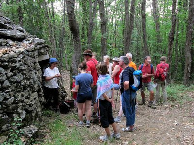
Meyrannes et le Montgrillet - JF.RAULET AgricultureLe Montgrillet
Le Montgrillet is the hillock above the village. The population of Meyrannes used to be overwhelmingly farmers, who lived on what they grew. Le Montgrillet is exposed to the sun and close to the village, and was the ideal spot for farming. Evidence for this can be seen all along the path. The grove of olive trees above the path indicates one of the crops once grown in Meyrannes, along with grapes and mulberry trees (for leaves to feed to silkworms). (B. Mathieu)

Le Four à Chaux - JF.RAULET  Know-how
The lime kiln
The limestone quarry was used to supply the lime-making kiln. Lime was much used in the countryside for improving soil, whitewashing walls and binding stones. In the lime-kiln, layers of coal alternated with limestone. Firing, which took more than 3 days, transformed the rock into lime. The kiln was constructed near the Montagnac river, the water being used to extinguish the quicklime. In use from 1853 on, the kiln has been disused for several years. (B. Mathieu)
Capitelle - © Brigitte Mathieu  Architecture
Dry-stone hut
This structure was built using dry-stoning techniques (i.e. without binder) and was once used by the farmer to store his harvest, tidy away his tools or take shelter when a storm about to burst did not leave him enough time to return home. The builder chose to make his hut back onto a terrace, so as to economise on one wall and save space. On this sloping land, efficiency is of the essence: the farmer has to make the most of every cultivatable square metre. Terrace walls built from stones serve to create horizontal plots, remove stones from the land and prevent erosion. (B. Mathieu)
Description
Signposts will guide you all along this route. In the description below, the signposted place names and/or directions are given in bold italics between quotation marks:
Starting from "Meyrannes", head towards "La Font de Bourboul" via "Meyrannes-le-Royal", "Les Faysses", "La Vigna Del Bos", "Les Calades" and "Le ruisseau de La Font de Bourboul". After a little detour to the fountain, return to "Meyrannes" via "Le ruisseau de La Font de Bourboul", "Les Faysses" and "Meyrannes-Le Royal".
This hike is taken from the guidebook Cévennes Haute Vallée de la Cèze, published by the Communauté de communes Cèze Cévennes as part of the collection Espaces Naturels Gardois and the label Gard Pleine Nature.
- Departure : Meyrannes
- Arrival : Meyrannes
- Towns crossed : Meyrannes and Saint-Brès
Forecast
Altimetric profile
Recommandations
Make sure your equipment is appropriate for the day's weather conditions. Remember that the weather changes quickly in the mountains. Take enough water, wear good shoes and put on a hat. Please close all gates and barriers after yourself.
Information desks

Tourism office CezeCévennes, Bessèges
14 rue de la République, 30160 Bessèges
This office is part of the National Park's associated tourist-information network, whose mission is to provide information on, and raise awareness of, the sites and events as well as the rules that must be observed in the National Park's central zone.
Open year-round
Tourism office Cèze-Cévennes Saint-Ambroix
Place de l'ancien Temple, 30500 Saint-Ambroix
This office is part of the National Park's associated tourist-information network, whose mission is to provide information on, and raise awareness of, the sites and events as well as the rules that must be observed in the National Park's central zone.
Open year-round
Access and parking
Via Alès towards St-Ambroix on the D 904, and then, as you leave St-Ambroix, towards Meyrannes on the D 51
Parking :
Calculateur d'itinéraire Lio
Utilisez le calculateur liO pour organiser votre trajet en région Occitanie.
Autres régions
Calculez votre itinéraire en Auvergne Rhône Alpes sur Oùra
Biodiversité autour de l'itinéraire
Source

Report a problem or an error
If you have found an error on this page or if you have noticed any problems during your hike, please report them to us here: