
Prunet
5 points of interest
Châtaignier en bord de route - Florac - Sud Lozère  Flora
FloraThe sweet-chestnut tree
Also called “the bread tree”, the sweet chestnut has deep roots in Cevenol history. It is difficult to say whether it already grew in the Cevennes before the area was settled by humans, but it greatly helped to nourish them and thus enable the area's demographic booms of the 12th, 16th and 19th centuries. Chestnuts were then planted in groves in much of the Cevennes. The trees were grafted to create varieties with chestnuts that ripened more or less early, in line with different uses: jam-making, drying, fodder for livestock. Over a hundred varieties have been identified - a veritable heritage, shaped by centuries of selection.
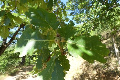
Chêne blanc - nathalie.thomas FloraThe white oak
Oak and chestnut trees grow at the same altitude (between 500 and 800 m), so that the expansion of chestnut groves occurred at the expense of oak. Here, the grove mostly consists of bouscas, ungrafted chestnut trees that grow as suckers out of tree stumps. The decline of chestnut groves, under whose canopy white oak regenerates well, has enabled it to resettle certain areas, especially on the adrets (south-facing slopes) and in areas of rock outcrops. White oaks are better at making do with stony and dry soils than sweet-chestnut trees.
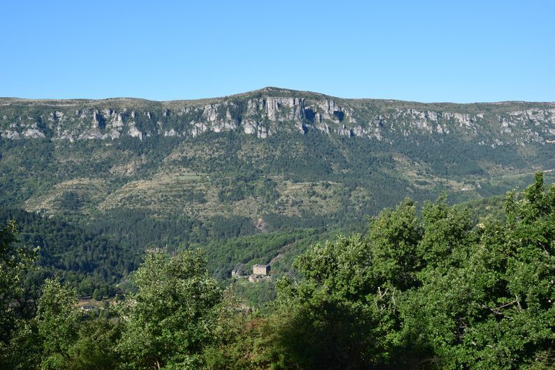
Vue sur le château de Montvaillant - Florac - Sud Lozère  History
The hamlet of Prunet
The hamlet used to be located not far from the two clèdes. It gave its name to the parish of Prunet-Montvaillant, which became La Salle Prunet at the French Revolution (Montvaillant being the name of the manor house that overlooks the road downstream from the village). A notarised agreement from 1206 refers to the “mas de Prunet vieux” (the Old Prunet estate or farmstead), Prunet church and the land of the inhabitants of Prunet. The dwellings and church were demolished. Few traces are left, the stones having since been reused to construct other buildings. It is not known for sure whether the hamlet's destruction dates back to old religious conflicts, prior to the Camisard War (1702-1704), or to a settling of scores with the village of Bédouès over grazing rights.
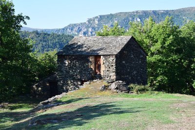
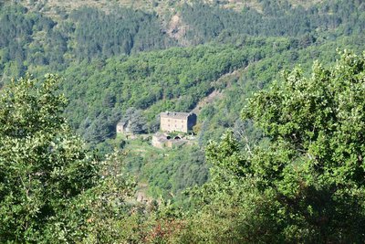
Clède - Florac - Sud Lozère  Architecture
Clède
Two small buildings stand on the edge of the path at its highest point. These are clèdes, or chestnut-drying buildings. The nuts were spread out on racks on the upper floor, and a small fire was maintained on the lower floor for 5 to 6 weeks. These two buildings were probably each used for a specific type of drying: one for supplying chestnuts to be peeled and eaten by the family; the other for producing chestnuts for livestock. The latter are dried less thoroughly and not peeled.
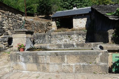
Fontaine de La Valette - nathalie.thomas ArchitectureLa Valette
La Valette lies at the limit between schist bedrock and the limestone of the small Chaumette plateau just above. Its houses are built from limestone, which is easier to carve than schist. As you look at the Mimente valley, you can see the hamlet of Aubuisson , perched on the rock, where a couple of German intellectuals, the Foekes, sought refuge during World War Two.
Description
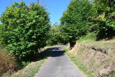
The walk starts from the car park at the town hall (mairie) in La Salle Prunet. Use the pedestrian crossing to cross the main road (N106), then go under the former railway bridge. Go up the concrete ramp and fork left. The path is briefly tarred and goes downhill for a few metres. Just after the stone house, the path goes uphill between houses on the right. The path comes out at the bottom of a field that you cross (50 m) to reach a larger path. Turn right onto this, towards La Valette. Continue on the main path through the chestnut grove and oak forest. At the crossing, continue straight ahead for the hamlet of La Valette, then return the way you came. Take the path that goes downhill on the left through the chestnut grove (electric fence – please close after yourself), then take the road on the right. After the hairpin bend, continue for 50 m to reach a path on the right, just above a house. Take the road to the last hairpin bend before the N106 main road, then turn right onto the old railway track to reach the village. Cross the bridge, continue for another 50 m and turn right to retrace your steps to the car park.
- Departure : Florac Trois Rivières (La Salle Prunet)
- Arrival : Florac Trois Rivières (La Salle Prunet)
- Towns crossed : Florac Trois Rivières
Forecast
Altimetric profile
Recommandations
Make sure your equipment is appropriate for the day's weather conditions. Remember that the weather changes quickly in the mountains. Take enough water, wear good shoes and put on a hat. Please close all gates and barriers after yourself.
Information desks

Tourism'house and national Parc at Florac
Place de l'ancienne gare, N106, 48400 Florac-trois-rivières
This office is part of the National Park's associated tourist-information network, whose mission is to provide information on, and raise awareness of, the sites and events as well as the rules that must be observed in the National Park's central zone.
On site: exhibitions, video projections, events and shop Open year-round
Transport
Bus line 258 “Florac – Sainte-Enimie – Le Rozier”, every day in July and August
Bus line 261 “Florac – Le Pont de Montvert – Mont Lozère”, every day in July and August
Bus line 251 "Florac – Mende”
Year-round daily service Monday to Saturday
Bus line 252 “Ispagnac – Florac – Alès”
https://lio.laregion.fr/
Access and parking
From Florac, take the N106 road direction Alès.
Parking :
Calculateur d'itinéraire Lio
Utilisez le calculateur liO pour organiser votre trajet en région Occitanie.
Autres régions
Calculez votre itinéraire en Auvergne Rhône Alpes sur Oùra
Biodiversité autour de l'itinéraire
Source


Report a problem or an error
If you have found an error on this page or if you have noticed any problems during your hike, please report them to us here: