
Baousse del Biel
3 points of interest
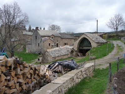
La Bourgarie - nathalie.thomas  Water
WaterLa Bourgarie
Gabriel still remembers with emotion when running water arrived in La Bourgarie. Work on the water supply started in 1965 but was not finished until 1971. The water comes straight from Mont Aigoual. When the first, long-awaited pump finally worked, he abandoned the cistern and the spring at the ends of the earth (i.e., at the cliffs), where he had previously taken his cattle to drink.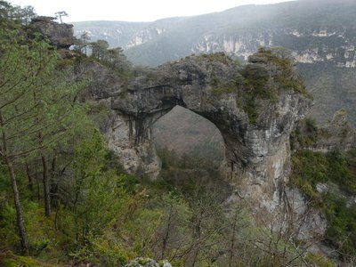
Baousse del Biel - nathalie.thomas  Geology
Baousse del Biel
The formation of the gorge also created incredible monuments, such as this triumphal arch, the Baousse del Biel (Occitan for the Old Man’s Hump or the Old Man’s (toothless) Mouth). This natural bridge is 40 m high, of which 27 m are below the arch, and the opening is 25 m long. It is believed that when the erosion that eventually created the canyons started, this site was a cave carved out by underground water from the Causse, 150 m above. The floor then collapsed under the weight of the vault. (Les Causses Majeurs, E.A.Martel)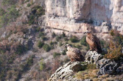
Vautours fauves - © Bruno Descaves  Fauna
FaunaBirds of prey
The large bird of prey soaring above you is a griffon or cinereous vulture. These birds had completely disappeared due to hunting and poisoning. They were reintroduced from 1971 onwards by the Ligue pour la protection des oiseaux (Bird Protection League) and the Cévennes National Park. Today, their population is estimated at over 400 couples. A third species of vulture joined them in 2012: the bearded vulture. It is the subject of a reintroduction programme. For updates on this latest arrival, see http://rapaces.lpo.fr/gypaete-grands-causses.
Description
From the car park, go up to the village, which you cross on the left-hand side.
1) By the last houses, go down on the right towards the cliff edge. The path runs along the cliff and stays mostly at the same height until you reach the ladders of Singlegros. NB: Do not descend to the “Pas de l’Arc”.
2) At the crossroads with the path down to the ladders of Singlegros, continue on the path veering to the left and, at the first fork, take the path on the left to return to the plateau.
3) Turn left onto the track (GR) to return to La Volcégure and then La Bourgarie.
- Departure : La Bourgarie
- Arrival : La Bourgarie
- Towns crossed : Massegros Causses Gorges and Saint-Pierre-des-Tripiers
Forecast
Altimetric profile
Recommandations
Not recommended for those who suffer from vertigo. Caution! The path is slippery when wet. Make sure your equipment is appropriate for the day’s weather conditions. Remember that the weather changes quickly in the mountains. Take enough water, wear sturdy shoes and put on a hat.
Information desks
Biosphera
18, rue vincent Faita, 30480 Cendras

Tourism'house and national Parc at Florac
Place de l'ancienne gare, N106, 48400 Florac-trois-rivières
This office is part of the National Park's associated tourist-information network, whose mission is to provide information on, and raise awareness of, the sites and events as well as the rules that must be observed in the National Park's central zone.
On site: exhibitions, video projections, events and shop Open year-round
Access and parking
From Meyrueis, take the D 986, then turn left onto D 9 towards St-Pierre-des-Tripiers. As you exit St-Pierre-des-Tripiers, take the road on the right to La Bourgarie.
Parking :
Calculateur d'itinéraire Lio
Utilisez le calculateur liO pour organiser votre trajet en région Occitanie.
Autres régions
Calculez votre itinéraire en Auvergne Rhône Alpes sur Oùra
Biodiversité autour de l'itinéraire
Source


Report a problem or an error
If you have found an error on this page or if you have noticed any problems during your hike, please report them to us here: