
Pont Marès
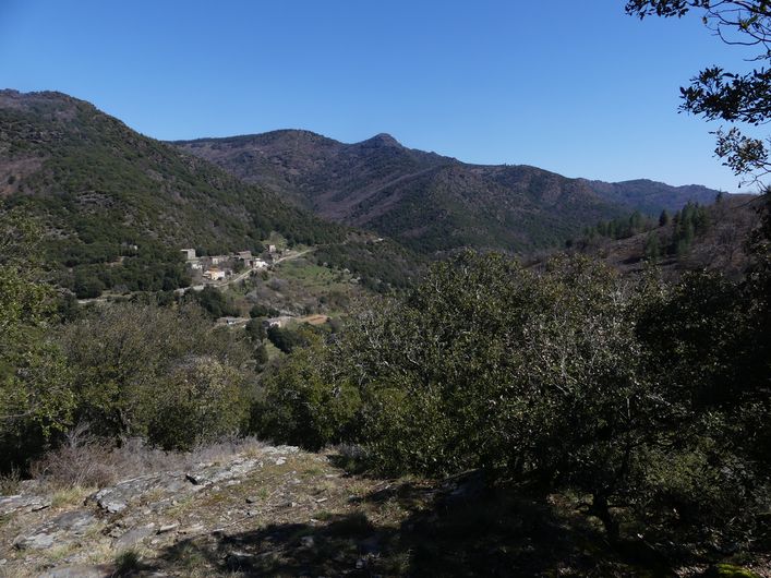
As you climb up to the Col de Salidès pass, you will discover a landscape and sites full of history: the Château de l'Hon (early 15th c.), whose lord was assassinated in 1826, and in the distance the Château du Poujol (14th c.) that overlooks the valley from its rocky outcrop. Imagine the atmosphere in the hamlet of Les Salidès, where the widow Verdier used to organise festive evenings at her inn.
4 points of interest
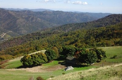
Maison du berger - Michel Monnot  Pastoralism
Summer pastures
Since time immemorial, animals have naturally migrated from the plains into the mountains in summer. The Salidès pass has summer pastures for sheep. The shepherd’s house is just below you on the Mediterranean side. The shepherd stays several months with about 800 sheep and a few dogs. Careful: patous, the big and handsome white dogs, are there to supervise and defend the herd!
It is important for the herd to graze here. The animals fertilise the soil and maintain the open spaces.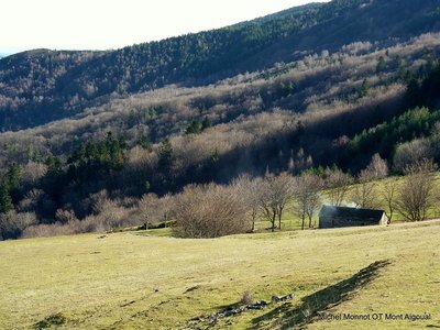
Le Col Salidès - Office de tourisme OTMACC AgricultureThe transhumant shepherd of the Col de Salidès
From the end of spring onwards, the Col de Salidès livens up. The transhumant shepherd moves up for the three months of summer grazing in this magical spot with almost 1,000 sheep. In all weather, the shepherd takes the animals outside so they can graze new grass. He has to both manage his pasture land and look after the sheep.
At the end of summer, each livestock farmer comes to recover his animals. Be careful around the dogs that watch over the flock!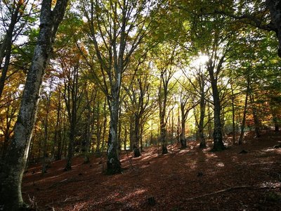
La forêt de hêtres - Béatrice Galzin  Natural environment
The forest of L’Hom
From the 19th century, the forest of L’Hom was the “reserve” of a private estate of over 700 hectares. Its animal stocks were protected and used as a “savings account” in the event of unforeseen financial needs. This situation in part explains the diversity of the forest, which stretches from 600 to 1,1000 m in altitude and contains many species: native (holm oak, sweet chestnut, beech, birch, wild cherry, rowan, pine, spruce, etc.) as well as exotic ones, which were introduced by the new owners (northern red oak, red maple, giant redwood, larch hybrids, etc.). This private forest has a management plan based on the prosylva principles (forestry close to nature), which was approved by the body in charge of forest management and the Cévennes National Park. There is abundant game, and you may spot a deer or stag on your walk.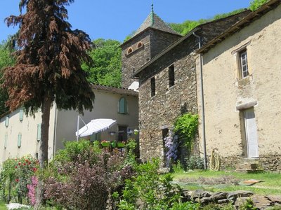
Le château de l'Hom - Béatrice Galzin  Architecture
The castles of the upper Vallée Borgne
The Château du Poujol is the last castle of the Vallée Borgne. It is located under the rocky ridge of the Can de l’Hospitalet to the north and the Col Salidès to the south. It was built in the 13th century on a rocky spur to watch over the valley. Locals laid out many terraces around the site, which gives you an idea of agricultural life in the Cévennes.
The Château de l’Hom sits in lush greenery. It is first mentioned in 1401. Many lords have left their trace in the architecture, but not only there. In 1826, an assassination took place on this spot, in connection to a goat’s ear cut off in punishment for eating the lady’s flowers…
Description
Signposts and yellow waymarks will guide you all along this route. In the description below, the signposted place names and/or directions are given in bold italics between quotation marks:
From the starting-point, walk towards "Col de Salidès" along the D 10a for about 600 m.
Take the path on the left that goes downhill to the River Gardon, which is crossed by a stone bridge. Continue on the path under the chestnut trees to the foot of Château de l’Hon.
Take the track that runs alongside the château on the right towards the hamlet of Les Salidès. Go through the hamlet and turn left onto the road for about 800 m.
NB. The track you want to take is on the right in a hairpin bend. Continue uphill to the junction with the D 907, rejoin the track opposite and continue to the Col de Salidès.
At the pass, take the forestry track on the left towards "St André de Valborgne" via "Réserve de l'Hon"
200 m after you enter the forest, at "Réserve de l'Hon", head towards "Pont Marès" on a path on the left that goes straight downhill into the chestnut forest.
Join up with a track, turn right onto it and walk to the D 907.
Turn right onto the road and go downhill on the left to the hamlet of Les Ginestoux. Go through the hamlet and keep heading downhill to Le Merlus. Return to Pont Marès via the pretty little bridge.
- Departure : Pont Marès – St-André de Valborgne
- Arrival : Pont Marès – St-André de Valborgne
- Towns crossed : Saint-André-de-Valborgne and Bassurels
Forecast
Altimetric profile
Recommandations
Caution! The climb to the Col de Salidès pass is also a downhill mountain-biking route. Before committing yourself to a circuit, ensure that it is suitable for your activity level and ability. Remember that the weather changes quickly in the mountains. Take enough water. Please close all gates and barriers behind you.
Caution: patous (livestock guard dogs) at the Col de Salidès! Seek advice on how to behave near these dogs from tourist offices and National Park information centres.
Information desks

Tourism office Mont Aigoual Causses Cévennes, Saint-André-de-Valborgne
les quais, 30940 Saint-André-de-Valborgne
This office is part of the National Park's associated tourist-information network, whose mission is to provide information on, and raise awareness of, the sites and events as well as the rules that must be observed in the National Park's central zone.

Tourism office Mont Aigoual Causses Cévennes, Valleraugue
7 quartier des Horts, 30570 Valleraugue
This office is part of the National Park's associated tourist-information network, whose mission is to provide information on, and raise awareness of, the sites and events as well as the rules that must be observed in the National Park's central zone. : Open year-round
Transport
liO is the regional public transport service of the Occitanie/ Pyrénées – Méditerranée region. It facilitates everyone’s movements by prioritising public transport. For more information, call 08 10 33 42 73 or go to www.laregion.fr
Access and parking
From St-Jean-du-Gard, towards St-André de Valborgne on the D 907, via L’Estréchure and Saumane. As you exit St-André de Valborgne, take the D 10 towards Le Pompidou. At 3km is Pont Marès and the starting-point.
Parking :
Calculateur d'itinéraire Lio
Utilisez le calculateur liO pour organiser votre trajet en région Occitanie.
Autres régions
Calculez votre itinéraire en Auvergne Rhône Alpes sur Oùra
Biodiversité autour de l'itinéraire
Source


Report a problem or an error
If you have found an error on this page or if you have noticed any problems during your hike, please report them to us here: