

Col de Peyrefiche
Walk between chestnut groves and holm oaks and through hamlets surrounded by gardens, orchards and crop terraces planted with mild Cévennes onions.
4 points of interest
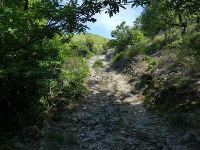
Chemin muletier - N Thomas  History
Camin Ferrat
The name camin ferrat, literally “iron road”, is obscure in origin. For some, it was a transit route for iron bars; for others, a route used by itinerant blacksmiths. The most likely explanation seems to be that it was used by shod beasts of burden. A local woman claims that the path was damaged by oxcarts laden with wood.
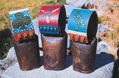
Sonnailles décorées - Parc national des Cévennes AgricultureTranshumance
For their transhumance (seasonal migration), sheep wear bells, also known as drailhes. In decreasing order of size, the bells are called the sonals, clapas and piques. Each has its own sound: sonals ring out “we’ll be climbing, we’ll be climbing”, clapas sing “we’re going down” and piques “we’re coming back”. After shearing, the sheep are marked so that their owners can tell them apart when they are jumbled together with other flocks. In the old days, tar or pitch were used; nowadays, it is paint. Examples of bells are on show at the Musée Cévenol in Le Vigan.
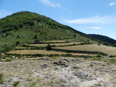
Col de Peyrefiche - N Thomas HistoryThe draille (drovers’ road)
At the pass, you join the draille (drovers’ road). These ancient pathways are believed to have been used since prehistoric times by herds of wild animals for their seasonal migrations. The drailles are sometimes lined by low dry-stone walls and marked out by standing stones, allowing shepherds to stay on the path even in bad weather. To this day, herds take a break at the Col de Peyrefiche pass and sometimes spend the night there, sheltered by the Pyrenean broom.

Peyrefiche - N Thomas HistoryPeyrefiche
Peyrefiche means standing stone; further on is the Col de la Pierre Plantée pass. In Ooccitan, peyra plantada designate either menhirs or else the stones marking out Celtic or Roman tracks. The latter used and improved the drovers’ roads, which became efficient traffic arteries. Some stones quite simply delineate territories.
Description
Signposts will guide you all along this route. In the description below, the signposted place names and/or directions are given in bold italics between quotation marks :
Starting at "MANDAGOUT", walk to "COL DE PEYREFICHE" via :
- "Mandagout - Centre",
- "La Planque",
- "Chemin de Rouas",
- "COL DE PEYREFICHE",
- "Peyrefiche",
- "Rouas" before returning to :
- "Chemin de Rouas" and then "MANDAGOUT" via "La Planque" and "Mandagout - Centre".
This walk is taken from the guidebook Les Vallées Cévenoles - En Pays Viganais, published by the Communauté de communes Pays Viganais-Cévennes as part of the collection Espaces Naturels Gardois and the label Gard Pleine Nature.
- Departure : Mandagout
- Arrival : Mandagout
- Towns crossed : Mandagout
Forecast
Altimetric profile
Recommandations
Make sure your equipment is appropriate for the day’s weather conditions. Take enough water, wear sturdy shoes and put on a hat. Please close any gates and barriers behind you.
Information desks

Tourism office Cévennes and Navacelles, Le Vigan
Maison de pays, place du Marché, BP 21, 30120 Le Vigan
This office is part of the National Park's associated tourist-information network, whose mission is to provide information on, and raise awareness of, the sites and events as well as the rules that must be observed in the National Park's central zone.
Open year-round
Transport
LiO is the regional public transport service of the Occitanie/ Pyrénées – Méditerranée region. It facilitates everyone’s movements by prioritising public transport. For more information, go to the lio Occitanie app or visit : https://www.mestrajets.lio.laregion.fr
Access and parking
From Le Vigan take the D170 to Gaujac, Beaulieu, Mandagout.
Parking :
Calculateur d'itinéraire Lio
Utilisez le calculateur liO pour organiser votre trajet en région Occitanie.
Autres régions
Calculez votre itinéraire en Auvergne Rhône Alpes sur Oùra
Biodiversité autour de l'itinéraire
Source


Report a problem or an error
If you have found an error on this page or if you have noticed any problems during your hike, please report them to us here: