
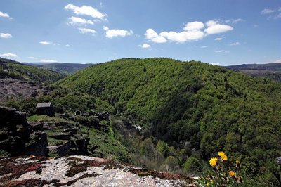
Château du Tournel
11 points of interest
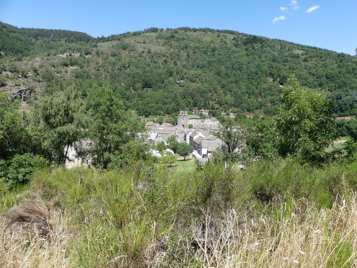
Montée sur Malmmont - Nathalie Thomas  Flora
FloraFlora
Along the paths, many flowers tell us that the sloping bedrock under our feet is schist (slate). The star-of-Bethlehem freshens up for 11 a.m.; the foxgloves raise their purple bell-shaped flowers; tufts of sheep’s fescue seem to have escaped from a summer pasture; biting stonecrop delights in the sunshine; yarrow hems the path in lace; the wild thyme you step on releases its fragrance...
Le Tournel - © Nathalie Thomas  History
Château du Tournel
A discovery path leads visitors through the history of the château and the configuration of the former village, today in ruins. Nobody knows what noble knight long ago chose this hill bordered by gullies to build his castrum. The first homage to Le Tournel was paid in 1219, by Odilon Guérin to the bishop and lord of Mende, Guillaume de Peyre.
Chapelle castral - © Brigitte Mathieu  Architecture
Chapel and residence
Marker 7
The residence and chapel, the oldest parts of the castle, were built for its religious and residential functions in the 12th century onwards. The castle chapel, dedicated to St Peter, was reserved for the lords' private use. Its barrel vault has collapsed. The choir was integrated into the curtain-wall tower, which shows that it was an element of the castle fortifications, as do its two openings shaped like arrow slits. The residence was lit by semi-circular bay windows with carved yellow-limestone surrounds. Its three floors can still be identified by the anchorage points for their beams. The east wall was defended by a hoarding : a projecting gallery from which the foot of the wall could be defended.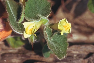
Muflier asaret - @ Yves Maccagno FloraA few plants
Marker 9
A few plant species are well-represented near the ruins, such as hoary plantain and mugwort. Among the plants that colonise the almost soil-less stone walls or rock faces are stonecrops (several species, notable for their succulent leaves); saxifrages (three species), which brighten up the rocky outcrops in spring with their white flowers; and navelwort. Trailing snapdragon with its yellow flowers streaked in pink exists almost exclusively in the Cévennes. On top of the tower wall, you will notice two rows of schist stones with rounded lower edges, an exceptional architectural detail. They probably date from the 12th century.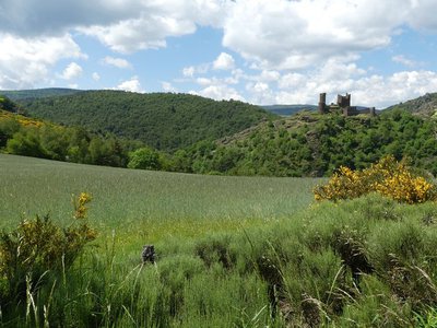
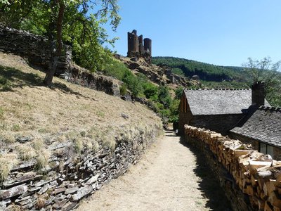
Le château du Tournel - © Nathalie Thomas ArchitectureKeep
Marker 8
The keep and redoubt are defensive elements. Through their massive appearance and their position, they asserted the lords' prestige and power. In the 13th century, the keep was redesigned to have a narrow winding entrance passage and a curtain wall on its west side. The first two floors were each occupied by a rectangular room with a vaulted ceiling and arrow-slit openings. Access from one level to the next was through a manhole. On the second floor, a wall still carries the imprint of the fireplace that once took up the whole back wall. A turret built onto the keep contained a spiral staircase that gave access to the third floor. Architecture
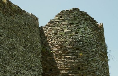
Redoubt
This tower was probably necessary to fortify the castle during the Hundred Years' War. Its extremely thick walls (1.7 m as compared to 80 cm for the residence) reinforce a corner of the castle wall and served as the last line of defence. They follow the contours of the vertical cliffs. The tower still shows the vestiges of three corbels just above the access door, which must once have supported a bretèche (small defensive balcony). Inside, the floors separated by vaulted ceilings are accessible through manholes.
- History
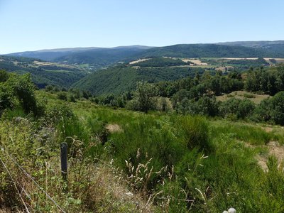
Traffic axes
Marker 6
Le Tournel is situated in a landscape that is covered by a network of traffic axes: two drailles (drovers' roads) and the Via Soteirana linking Villefort with Mende. Because of its geographical position, the Château du Tournel was a dominant feature and played a prominent role in monitoring the territory, its people and their movements. The Via Soteirana, a former Royal road, seems to have been crucial for mining operations in the surrounding area. It was also a non-negligible source of income for the castles built at intervals along it, because of the tolls imposed on every user. - Architecture
Watchtower
Marker 5
The similarities in construction between the watchtower and the keep date both buildings to the 13th century. The tower, part of the first settlement of the site, served as the advance defences of the original village. Later it found itself at the centre of the site, and from there protected and controlled the one-road village. Its walls are 1.2 m thick and the closing system of the door – with a sliding bar – can still be seen. Probably damaged during a fire, it was transformed into a dwelling with two storeys, separated by a wooden floor that replaced the destroyed vaulted ceiling. The anchorage points for its joists can still be seen in the masonry.  Geology
Rock with cup marks
Marker 4
Below this barite boulder, which blocks access to the spur and thus protected the castle and original village, there is a rock with nine circular holes of varying sizes: cup marks. They are not placed in any particular pattern and do not seem to have been used as anchorage points. Could erosion have hollowed out the rock in this way? This phenomenon exists in many places In the Cévennes, always in schist. When nature reclaims rock faces, it first establishes lichen there. These crust-like organisms with their various colours cause the rock to crumble, which is necessary for other plants to be able to establish themselves.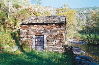
Le moulin restauré de Saint-Julien-du-Tournel - @ Guy Grégoire HistoryMill
In feudal times, villagers using mills had to pay a fee to their lord. From the French Revolution onwards, mills became the joint property of locals, who were responsible for their upkeep. Le Tournel mill with its schist walls and roof was built below the village, a few steps from the Lot, in 1820. Powered by water flowing through a béal (open channel), the mill produced rye and wheat flour before each bread-baking, bread being the basis of the local diet. In about the mid-20th century, these mills stopped being used. Le Tournel mill, which was well-preserved, has recently been restored.
@ Yannick Manche HistoryThe site is abandoned
From the 13th century on, the local lords preferred the more comfortable Château du Boy while some inhabitants chose the security of the city of Mende over the protection afforded by castles. The steep location of the village, the demographic crises of the 14th and 15th centuries, the plague, and the end to territorial conquest may also explain the gradual abandonment of the site. In the 19th century, only a few houses were still inhabited, and the land was barely used. The one-road village was definitively abandoned in 1930, when today's hamlet of Le Tournel was built along the western slope of the spur.
Description
Signposts will guide you all along this route. In the description below, the signposted place names and/or directions are given in bold italics between quotation marks :
Starting at « Mas d’Orcières », go to :
- « Les Quincos », then
- « Sous la croix de Calvaire »,
- « La Reveirette ». Then direction « Château du Tournel » via :
- « Lavignolle »,
- « La Combe »,
- « Les Parets ».
At « Château du Tournel » direction « Mas d’Orcières » via : - « Le Tournel »,
- « Bois Dario »,
- « Orcières », « Village ».
This hike is taken from the guidebook Mont Lozère – Pays des sources, de la montagne du Goulet aux gorges du Bramont, published by the Pôle de pleine nature du Mont Lozère.
- Departure : Mas d'Orcières
- Arrival : Mas d'Orcières
- Towns crossed : Mont Lozère et Goulet
Forecast
Altimetric profile
Recommandations
Make sure your equipment is appropriate for the day’s weather conditions. Remember that the weather changes quickly in the mountains. Take enough water, wear sturdy shoes and put on a hat. Please close any gates and barriers behind you.
Information desks

Tourism'house and national Parc at Florac
Place de l'ancienne gare, N106, 48400 Florac-trois-rivières
This office is part of the National Park's associated tourist-information network, whose mission is to provide information on, and raise awareness of, the sites and events as well as the rules that must be observed in the National Park's central zone.
On site: exhibitions, video projections, events and shop Open year-round

Tourism office Mont-Lozère, Bagnols-les-Bains
avenue de la gare, 48190 Bagnols-les-Bains Mont-Lozere et Goulet
This office is part of the National Park's associated tourist-information network, whose mission is to provide information on, and raise awareness of, the sites and events as well as the rules that must be observed in the National Park's central zone. Open from mid-April to late September

Tourism office Mont-Lozère, Villefort
43, Place du Bosquet, 48800 Villefort
This office is part of the National Park's associated tourist-information network, whose mission is to provide information on, and raise awareness of, the sites and events as well as the rules that must be observed in the National Park's central zone.
Open year-round
Access and parking
From Mende, towards Badaroux on the N88, then towards Bagnols-les-Bains, Le Tournel on the D901. After the tunnel, turn right towards Mas d’Orcières.
Parking :
Calculateur d'itinéraire Lio
Utilisez le calculateur liO pour organiser votre trajet en région Occitanie.
Autres régions
Calculez votre itinéraire en Auvergne Rhône Alpes sur Oùra
Biodiversité autour de l'itinéraire
Source


Report a problem or an error
If you have found an error on this page or if you have noticed any problems during your hike, please report them to us here: