

1. From valley to valley – between Gardon and Tarnon (day 1)
10 points of interest
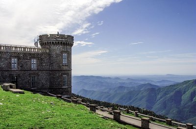
Météosite de l'Aigoual - © Olivier Prohin  Water
WaterMont Aigoual
A beautiful view onto Mont Aigoual (1,567 m) – a mountain of winds, fog, snow and rain. Banks of clouds coming from the Mediterranean rub against its slopes and can cause violent precipitation (also called Cévenol episodes). This temperamental mountain is home to the last mountain weather-station in France.
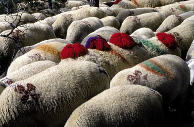
Transhumance - © Michelle Sabatier AgricultureThe Margeride draille (drovers’ road)
The draille follows the ridge and crosses the Can de l'Hospitalet plateau. This transhumant trail enables the sheep flocks of the plains (of the southern Cévennes and the Crau) to move up to northern Gévaudan (Aubrac, Margeride, Mont Lozère). This draille is only one branch of a larger network along which transhumant livestock still travel.
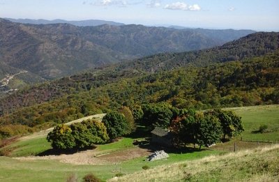
Maison du berger - Michel Monnot  Pastoralism
Summer pastures
Since time immemorial, animals have naturally migrated from the plains into the mountains in summer. The Salidès pass has summer pastures for sheep. The shepherd’s house is just below you on the Mediterranean side. The shepherd stays several months with about 800 sheep and a few dogs. Careful: patous, the big and handsome white dogs, are there to supervise and defend the herd!
It is important for the herd to graze here. The animals fertilise the soil and maintain the open spaces.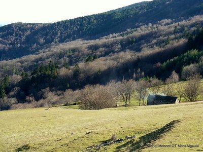
Le Col Salidès - Office de tourisme OTMACC AgricultureThe transhumant shepherd of the Col de Salidès
From the end of spring onwards, the Col de Salidès livens up. The transhumant shepherd moves up for the three months of summer grazing in this magical spot with almost 1,000 sheep. In all weather, the shepherd takes the animals outside so they can graze new grass. He has to both manage his pasture land and look after the sheep.
At the end of summer, each livestock farmer comes to recover his animals. Be careful around the dogs that watch over the flock!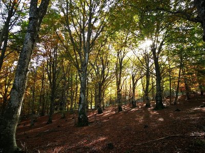
La forêt de hêtres - Béatrice Galzin  Natural environment
The forest of L’Hom
From the 19th century, the forest of L’Hom was the “reserve” of a private estate of over 700 hectares. Its animal stocks were protected and used as a “savings account” in the event of unforeseen financial needs. This situation in part explains the diversity of the forest, which stretches from 600 to 1,1000 m in altitude and contains many species: native (holm oak, sweet chestnut, beech, birch, wild cherry, rowan, pine, spruce, etc.) as well as exotic ones, which were introduced by the new owners (northern red oak, red maple, giant redwood, larch hybrids, etc.). This private forest has a management plan based on the prosylva principles (forestry close to nature), which was approved by the body in charge of forest management and the Cévennes National Park. There is abundant game, and you may spot a deer or stag on your walk.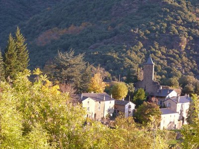
Hameau du château du Folhaquier - Béatrice Galzin  History
Château du Folhaquier
The Château du Folhaquier is outlined on this small ridge, which was a strategic site in the Middle Ages, overlooking the Gardon de Saint-Jean river and the Château de La Fare opposite.
It is separated from the hamlet by a ditch cut into the schist bedrock, and a square tower can still be seen that was built in the 16th century on 12th century ramparts, as well as the vestiges of a round tower at the other end. The foundations of the castle chapel are easy to distinguish, and the Romanesque church of Notre-Dame du Folhaquier, which remains in an excellent state, has withstood the elements for almost a millennium.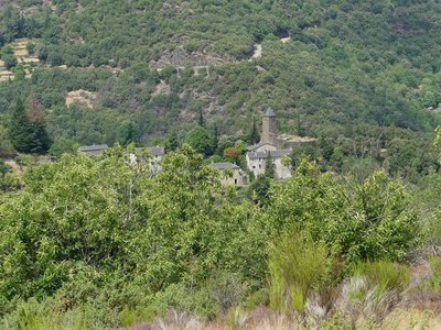
Le château du Folhaquier - Nathalie Thomas  Architecture
The mediaeval castles
Very close to the village of St-André de Valborgne, on the edge of a cliff, stand the remains of the castrum of La Fare, a defensive castle believed to date from the 12th century. Only a wall face of the tower survives. The ruins above bear witness to the site’s importance. The archives mention a well, cistern and drawbridge – but on site nothing remains. On the next spur is the majestic and dominating castle of Le Folhaquier. Transformations throughout the centuries by various owners have shaped the hamlet as we see it today. The era of silk farming strongly influenced the landscape by welcoming the “tree of gold”, the mulberry tree.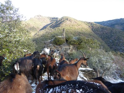
Les ruines du château de la Fare - capri’ces des Cévennes HistoryChâteau de la Fare
Following on from many battles against the Château du Folhaquier, today all that is left of the large mediaeval castle of the Lord de la Fare is this expanse of wall. Built at the summit of a schist hill, the castle is surrounded by sheer drops on all sides. The former village was fortified and located just below the expanse of wall. Sources indicate that the castle had a drawbridge and a chapel.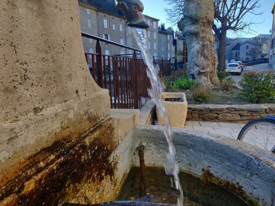
© Béatrice Galzin WaterOne spring, five fountains
This fountain is one of Saint-André’s five public fountains, all of which are supplied by the same spring (its water is thus the same as in the Fontaine du Griffon). Before houses were connected to mains water, there were many more fountains on this side of the quay.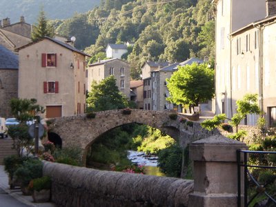
Le village de St André de Valborgne - Béatrice Galzin ArchitectureThe village of St André de Valborgne
As you stroll along the quay above the river, you can still see the handsome bourgeois houses dating from the silk boom. If you look around, former spinning mills and industrial buildings dedicated to silk farming can still be seen in the landscape. A little lower down, opposite the 16th century château, you can listen to
Bernadette Lafont on the Camisard saga in and after 1702. As you reach the square again, quench your thirst at the fountain and have a look inside the Romanesque church (12th century).
Description
Starting from “Rousses”, take the path above the village and join the GR®7 long-distance hiking path on the ridge of the Can de l’Hospitalet plateau.
- Turn right on the GR®7 towards “Col Salidès”, through the Tunnel du Marquaires.
- At “Col Salidès”, leave the GR®7, taking on your left a path towards “St-André de Valborgne” via “Mézariès” (yellow waymarks).
- Departure : Rousses
- Arrival : St-André de Valborgne
- Towns crossed : Rousses, Bassurels, and Saint-André-de-Valborgne
Forecast
Altimetric profile
Recommandations
Make sure your equipment is appropriate for the day’s weather conditions. Remember that the weather changes quickly in the mountains. Take enough water, wear sturdy shoes and put on a hat. Please close any gates and barriers behind you.
Caution : patous (livestock guard dogs) at the Col de Salidès pass from June to September! Seek advice on how to behave near these dogs from tourist offices and National Park information centres.
Information desks

Information center Le Pompidou
La poste, 48400 Le Pompidou
This centre is part of the National Park's associated tourist-information network, whose mission is to provide information on, and raise awareness of, the sites and events as well as the rules that must be observed in the National Park's central zone. :
Open year-round

Tourism & national parc'house
Col de la Serreyrède, 30570 Val d'Aigoual
The Maison de l'Aigoual houses the tourism office Mont Aigoual Causses Cévennes and the Maison du Parc national. This visitor centre provides information on and raises awareness of the Cévennes National Park, its sites and events as well as the rules that must be observed in the National Park's central zone.
On site: changing exhibitions, video projections, Festival Nature events and shop Open year-round

Tourism'house and national Parc at Florac
Place de l'ancienne gare, N106, 48400 Florac-trois-rivières
This office is part of the National Park's associated tourist-information network, whose mission is to provide information on, and raise awareness of, the sites and events as well as the rules that must be observed in the National Park's central zone.
On site: exhibitions, video projections, events and shop Open year-round

Office de tourisme Des Cévennes au mont Lozère
le Quai, 48220 Le Pont de Montvert sud mont-Lozère

Tourism office Mont Aigoual Causses Cévennes, Saint-André-de-Valborgne
les quais, 30940 Saint-André-de-Valborgne
This office is part of the National Park's associated tourist-information network, whose mission is to provide information on, and raise awareness of, the sites and events as well as the rules that must be observed in the National Park's central zone.
Access and parking
From Florac-Trois-Rivières on the D907 – from St-Jean du Gard on the D907.
Parking :
Calculateur d'itinéraire Lio
Utilisez le calculateur liO pour organiser votre trajet en région Occitanie.
Autres régions
Calculez votre itinéraire en Auvergne Rhône Alpes sur Oùra
Biodiversité autour de l'itinéraire
Source

Report a problem or an error
If you have found an error on this page or if you have noticed any problems during your hike, please report them to us here: