
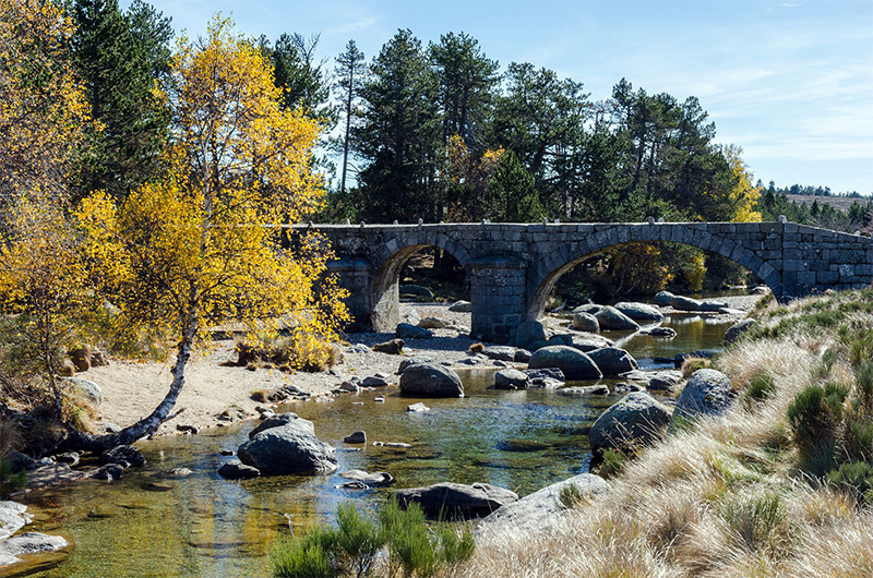
Pont du Tarn
Typical Mont Lozère hamlets such as L'Aubaret or Troubat, in the central zone of the Cévennes National Park, bear witness to a life of self-sufficiency. At the Pont du Tarn, you can cool off in the pure and invigorating waters of the Tarn, not far from its spring.
3 points of interest
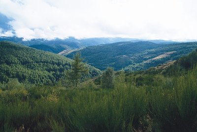
Boisement du Bougès sud - © Guy Grégoire  Flora
FloraThe Bougès state forest
This covers an area of about 3,300 hectares. Reforestation was carried out between 1880 and 1925, at the beginning of the agricultural decline, to fight the erosion caused by over-grazing. Today, the Office National des Forêts manages this forest, primarily with the goal of protecting the different forest species and ecosystems, but also with a view to making it productive. The forest is made up of a number of tree species, including spruce, silver fir, larch and Corsican pine. A varied fauna inhabits the forest (deer, wild boar, birds of prey). A few capercaillies, re-introduced by the Cévennes National Park, live in these wide open spaces. (Julie Hugon)
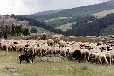
Transhumance sur la draille de l'Aubaret - © Olivier Prohin  Pastoralism
The draille du Languedoc
This draille (path for seaonal livestock migration) was frequented by flocks of sheep during the transhumance and by farmers going to buy or sell animals at Bellecoste Fair, which was held every 16 July and 25 September. The path linked the inhabitants of the plateau to the village of Saint-Maurice-de-Ventalon. (Julie Hugon)
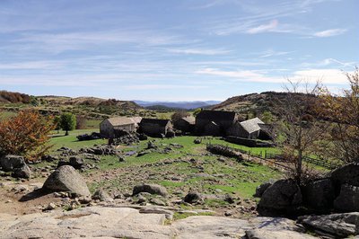
La draille et l'Aubaret - © Bruno Daversin  Architecture
The hamlets of L'Aubaret and Troubat
The houses in the hamlets of L'Aubaret and Troubat seem to have emerged from the ground amidst a mass of granite blocks. The refined architecture of these two handsome farms indicates a certain wealth (mullion windows, carved corbels, etc.). The agricultural equipment on site shows that these farms were self-sufficient (threshing-floor, mill, bread oven, etc.). Near the Pont du Tarn is a large draille that used to cross the river at “Gap Francès” (meaning “the Franks' ford”, the former limit between the Frankish and Visigoth realms.
Description
Signposts will guide you all along this route. In the description below, the signposted place names and/or directions are given in bold italics between quotation marks :
Starting at "Masméjean", walk to "Plo de la Nassette" via:
- "Col des Rouvières" then
- "Les Bastides". Go to "L'Aubaret" via :
- "Plo de la Nassette", then
- "Plo de l'Estrade",
- "Draille du Languedoc" then
- "Pont de l'Aubaret".
- At "L'Aubaret", go to "Pont du Tarn" via:
- le "Gap Francès", then turn left towards :
- "La Plaine du Tarn". Return at "Masméjean" via :
- "Troubat".
This hike is taken from the guidebook Mont Lozère – Pays des sources, Sommet des Cévennes, published by the Pôle de pleine nature du Mont Lozère..
- Departure : Masméjean
- Arrival : Masméjean
- Towns crossed : Pont de Montvert - Sud Mont Lozère and Vialas
Forecast
Altimetric profile
Recommandations
The Alignon ford may be impassable when the river is in flood. If necessary, continue on the road instead. Make sure your equipment is appropriate for the day's weather conditions. Remember that the weather changes quickly in the mountains. Take enough water, wear good shoes and put on a hat. Please close all gates and barriers after yourself.
Information desks

Tourism'house and national Parc at Florac
Place de l'ancienne gare, N106, 48400 Florac-trois-rivières
This office is part of the National Park's associated tourist-information network, whose mission is to provide information on, and raise awareness of, the sites and events as well as the rules that must be observed in the National Park's central zone.
On site: exhibitions, video projections, events and shop Open year-round

Office de tourisme Des Cévennes au mont Lozère
le Quai, 48220 Le Pont de Montvert sud mont-Lozère
Access and parking
5 km from Pont-de-Montvert, D 998 towards Masméjean via La Baraquette.
Parking :
Calculateur d'itinéraire Lio
Utilisez le calculateur liO pour organiser votre trajet en région Occitanie.
Autres régions
Calculez votre itinéraire en Auvergne Rhône Alpes sur Oùra
Biodiversité autour de l'itinéraire
Source


Report a problem or an error
If you have found an error on this page or if you have noticed any problems during your hike, please report them to us here: