
2. From Le Vigan to Mont Aigoual – Day 2
1 point of interest
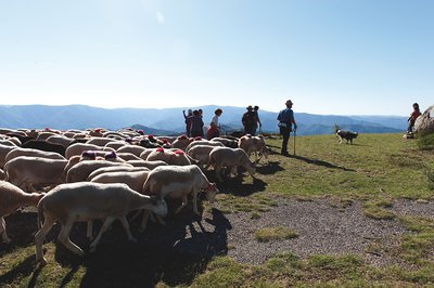
Passage de la transhumance au col de l'Asclié - © Olivier Prohin  History
The origins of the mouflon
Marker 6
L'Abeuradou is located on a draille, a drovers' road for shepherds and their flocks to move between the plains of Languedoc and summer pastures on the southern Massif Central. The name L'Abeuradou indicates that it is a spot where the flocks drink and rest before continuing their long hike. Today's domestic sheep is descended from the mouflon. Since being introduced to the slopes of Mont Aigoual, the mouflon has thus been rubbing shoulders with its cousin, which grazes here in summer. Their cohabitation does not seem to be a problem for the livestock farmers.
Description
Signposts will guide you all along this route. In the description below, the signposted place names and/or directions are given in bold italics between quotation marks :
- Starting from "CAP DE COTE", walk to “COL DE MONTALS” via "La Draille", “Abri des Abéouradous”, “Sous la Luzette” and “Montagne d’Aulas” (GR®60 long-distance hiking path).
- At “COL DE MONTALS” continue to “LA HETRAIE” and “Bois de Montals”.
- At “Bois de Montals” take the fork towards “PUEYLONG” (GR®7).
- At “PUEYLONG” continue on the GR®7 to “Le Font des Douzes”, “LES DOUZES” (GR®7, GR®60).
- At “LES DOUZES” walk to “LA HALLE DE L’ESPEROU” via “La Halle” (yellow waymarks).
- Departure : Cap de Côte
- Arrival : L'Espérou
- Towns crossed : Arphy, Val-d'Aigoual, Bréau-Mars, and Dourbies
Forecast
Altimetric profile
Recommandations
Make sure your equipment is appropriate for the day’s weather conditions. Remember that the weather changes quickly in the mountains. Take enough water, wear sturdy shoes and put on a hat.
Information desks

Tourism office Cévennes and Navacelles, Le Vigan
Maison de pays, place du Marché, BP 21, 30120 Le Vigan
This office is part of the National Park's associated tourist-information network, whose mission is to provide information on, and raise awareness of, the sites and events as well as the rules that must be observed in the National Park's central zone.
Open year-round
Calculateur d'itinéraire Lio
Utilisez le calculateur liO pour organiser votre trajet en région Occitanie.
Autres régions
Calculez votre itinéraire en Auvergne Rhône Alpes sur Oùra
Biodiversité autour de l'itinéraire
Source

Report a problem or an error
If you have found an error on this page or if you have noticed any problems during your hike, please report them to us here: